GLIAG | STRATEGIC PETROLEUM INTELLIGENCE
GLIAG ESSAY · GLIAG-ESS-2026-1011-TBJ-001 · VERSION 1.0 · 11 OCTOBER 2026 · GIP REV 0.22.96
The Second Tambaredjo
Reading Suriname’s onshore giant through gravity, magnetics and a century of coastal geology, then following its oil back to the kitchen to find the twin
Drs. M.P.T. (Marcel) Chin-A-Lien, MBA, M.Sc., Ing. Geologist
Principal Founding Partner, Managing Partner & Chief Architect, Golden Lane Investments Advisory Group B.V. (GLIAG)
AAPG Certified Petroleum Geologist Nr. 5201-1996 · EFG Chartered European Geologist Nr. 92-1996 · AIEN Energy Negotiator, June 2021
Zoetermeer · Paramaribo · petroleumenergyinsights.com · GLIAG GSB Intelligence Platform™
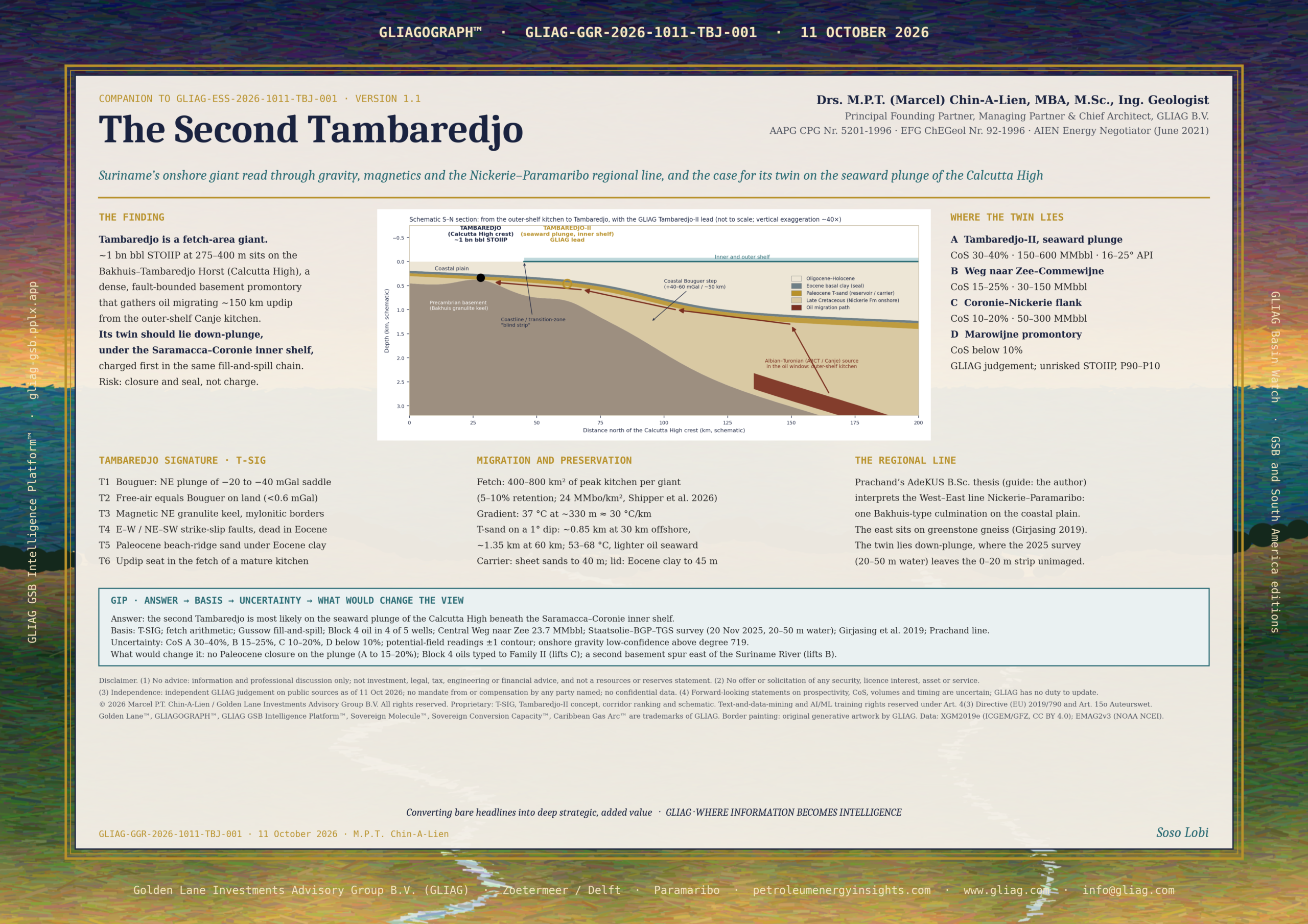
| THE FINDING Tambaredjo is a fetch-area giant. About 1 billion barrels of oil in place sit in Paleocene sands 275–400 m deep because a dense, fault-bounded basement promontory, the Bakhuis Horst (locally the Calcutta High), reaches north under the coastal plain and collects oil that migrated roughly 150 km updip from the outer-shelf Canje kitchen (Nelson 2016; GeoExpro 2016). On the three GIP potential-field maps the field sits where a north-east-trending granulite ridge (a −20 to −40 mGal Bouguer saddle between −80 mGal granite lows, coincident with a strongly magnetic basement zone) meets the 40–60 mGal coastal gravity step. GLIAG combines these readings with four geological criteria into the Tambaredjo Signature (T-SIG): dense basement promontory, inherited NE–SW and E–W strike-slip faults, a transgressive beach-ridge sand under an Eocene clay lid, and an updip seat in the fetch of a mature kitchen, shallow enough to trap and cool enough to biodegrade. The best look-alike lies one step seaward on the same promontory: the plunge of the Calcutta High beneath the Saramacca–Coronie inner shelf, where Staatsolie announced a South-Central Shallow Offshore 3D survey in October 2025 (Staatsolie). GLIAG names it Tambaredjo-II. Because Tambaredjo filled with about 1 billion barrels after the Middle Pliocene, any closure on that plunge sat in the same fill-and-spill chain and was charged first. Its risk is trap and seal, not charge (judgement: geological chance of success 30–40%; unrisked 150–600 MMbbl STOIIP, P90–P10; expected 16–25° API). Two sister corridors follow: Weg naar Zee–Commewijne in the east (15–25%) and Coronie–Nickerie in the west (10–20%). The Marowijne greenstone promontory ranks last (below 10%). |
KEY FINDINGS
1. Anchor.
Tambaredjo, Calcutta and Tambaredjo North-West hold about 1 billion barrels STOIIP in a sediment wedge less than 900 m thick, with more than 1,600 production wells and about 17,000 bopd (Nelson 2016).
2024 output was 6.4 MMbbl, with 104.5 MMbbl remaining reserves at 31 December 2024 (Staatsolie Annual Report 2024).
2. Potential-field address.
The field lies on the north-eastern plunge of the Bakhuis gravity saddle and landward of the coastal Bouguer step.
Onshore, free-air and Bouguer maps differ by less than 1 mGal, so the first two maps read as one map on land and diverge only offshore (GLIAG calculation, Section 3).
3. Fetch.
Trapping 1 billion barrels needs roughly 400–800 km² of peak-yield kitchen draining to one point if 5–10% of expelled oil is retained (GLIAG calculation on Shipper et al. 2026).
Tambaredjo is large because of where it stands, not because its rock is exceptional.
4. Twin.
The seaward plunge of the same high (Tambaredjo-II) ranks first; the transition-zone strip between swamp and 5 m of water is the least-imaged belt in the basin and the most likely hiding place.
5. Preservation.
Tambaredjo’s 37 °C at about 330 m implies about 30 °C/km.
On a 1° regional dip the T-sand reaches about 0.85 km depth 30 km offshore and about 1.35 km at 60 km, at 53–68 °C: still within the biodegradation window, but slower, so lighter oil is expected seaward (GLIAG calculation).
6. Decision use.
A NE-trending GIP profile through Tambaredjo to Block 52, an airborne gravity-gradiometry (FTG) survey across the coastal transition zone, and the Staatsolie South-Central 3D can test Tambaredjo-II for a small fraction of the cost of one offshore well.
1. Why Tambaredjo, and why a twin
Suriname became an oil country by accident.
In 1965 the Geological Mining Service (GMD) drilled for water in a schoolyard in Calcutta, Saramacca, and struck oil at about 160 m (Nelson 2016).
Oil had first been confirmed in Nickerie in the 1930s in well NN-1, and Shell drilled 20 coastal wells in 1969–1970 with limited success.
Staatsolie, founded on 13 December 1980, drilled three successful wells in 1981 and started production on 25 November 1982 at 250 bopd from five wells (SPE 104068).
By 2014 cumulative production had reached about 110 MMbbl at an estimated ultimate recovery factor of 20% (Nelson 2016).
Since his Staatsolie years in Paramaribo (2008–2010) the author has asked one question of every coastal seismic line: where is the second one?
Giant heavy-oil accumulations on shield margins rarely stand alone.
Across the same Guiana Shield, the Orinoco Heavy Oil Belt of eastern Venezuela forms a continuous belt of biodegraded oil on the shield’s northern flank, fed by long updip migration from a foreland kitchen.
Tambaredjo shares that geometry at a smaller scale.
This essay asks whether it is a solitary accident or the first known member of a Surinamese belt, and where the next member should sit.
The method follows the companion essays of 11 October 2026: read the field on the three regional potential-field grids of the GLIAG GSB Intelligence Platform™, integrate the coastal-plain geology, define a screening signature, and rank where it repeats (Stone and Weight, GLIAG-ESS-2026-GRV-001; The Golden Lane™ in the Potential Field, GLIAG-ESS-2026-1011-GLPF-001).
2. Data and method
| Source | Content | Role here |
| GIP GRV-01 free-air | XGM2019e_2159 via ICGEM/GFZ, CC BY 4.0; 2′ grid (~4 km); 10 mGal contours | Map 1: shelf break; onshore equal to Bouguer within 1 mGal |
| GIP GRV-01 Bouguer | Same model; 20 mGal contours | Map 2: Bakhuis saddle, granite lows, coastal step |
| GIP MAG-01 | EMAG2v3, NOAA NCEI, upward-continued to 4 km; 25 nT contours; not reduced to pole | Map 3: basement fabric, horst-bounding shear zones |
| Coastal-plain stratigraphy | Wong 1986, Geologie en Mijnbouw 65 | Formations, facies, thickness trends, Bakhuis influence |
| Field geology | Dronkert & Wong; SPE 104068; GeoExpro 2016 | Trap, reservoir, faults, depth, temperature |
| National synthesis | Nelson 2016; Staatsolie GeoAtlas; SHO synopsis; GeoPortal | Exploration history, oil families, plays, nearshore results |
| Basin model | Shipper, Mann & Pepper 2026 | Kitchen position and expulsion yields |
| Basement | Kroonenberg et al. 2016; de Roever et al. 2003; Geoscience Frontiers 2020 | Bakhuis granulite horst: age, P–T, structure |
| Local theses | Anton de Kom University (AdeKUS) catalogue, Annex A | Basement, well behaviour, EOR, sand control |
Limits stated up front.
Onshore, XGM2019e wavelengths beyond degree 719 are modelled from topography, so onshore detail is low-confidence (Zingerle et al. 2020).
A 4 km grid resolves the Bakhuis Horst and the coastal hinge, not the trap: the Tambaredjo field, about 200 km² in the early development phase (Dronkert & Wong), spans about a dozen grid cells.
Map readings below are taken from the GIP renderings published in the two companion essays and carry ±1 contour interval; readings at the field itself are marked [VERIFY: GIP cursor readout].
The full GeoAtlas PDF exceeded GLIAG’s retrieval limit for this edition, so plate-level statements on fans and river lineaments are marked [VERIFY: GeoAtlas plate].
3. Tambaredjo characterised
3.1 The field card
| Parameter | Value | Source |
| Discovery | 1965, GMD water well, Calcutta schoolyard, ~160 m; wildcat C9 near Calcutta in 1968; semi-commercial test in TA-4 | Nelson 2016; SPE 104068 |
| Fields and start-up | Tambaredjo 1982; Calcutta 2003; Tambaredjo North-West 2009 | GeoExpro |
| Reservoir | Paleocene T-sand (average ~5 m; 3–45 ft range); hydrocarbons from Saramacca (Paleocene) to Coesewijne (Miocene) sands | Dronkert & Wong; SPE; GeoExpro 2016 |
| Lithology | Angular, medium to coarse, unconsolidated sands with interfingering clays and lignites | Dronkert & Wong |
| Depth, temperature, pressure | 275–400 m; 37 °C; hydrostatic | SPE 104068 |
| Porosity, permeability | Up to 35%; up to 1,100 mD | Nelson 2016 |
| Trap | Structural highs from syn-sedimentary rejuvenated basement faults, plus stratigraphic pinch-out; E–W Tambaredjo Fault and NE–SW Broederschap Fault, mostly strike-slip | Dronkert & Wong; GeoExpro 2016 |
| Seal | Continuous clay of 10–20 m above the oil sands; Eocene basal clay up to 45 m regionally; shell banks locally | Wong 2016 editorial; Wong 1986; Nelson |
| Oil | 14–16° API, biodegraded; Oil Family I, marine shale source at peak maturity | Dronkert & Wong; Nelson |
| Oil in place | ~1 billion bbl, three fields combined | Nelson 2016 |
| Wells, rate | >1,600 production wells; ~17,000 bopd (2016); 6.4 MMbbl in 2024 | Nelson; AR 2024 |
| Reserves | 104.5 MMbbl remaining at 31 Dec 2024 | Staatsolie AR 2024 |
| Cover | Clastic wedge <900 m over crystalline basement; thinnest on the Calcutta Uplift, thickening east and west | Nelson; GeoExpro 2016 |
3.2 Two billion years in one column
Tambaredjo is the sum of a very old keel and a very young charge. The table reads from the bottom of the column to the present.
| Interval | Event | What it did for Tambaredjo |
| 2.09–2.03 Ga | Bakhuis ultrahigh-temperature granulites form above 1,000 °C at 0.9–1.0 GPa; later raised as a NE-trending horst bounded by long mylonitised faults, coincident with a strongly anomalous magnetic zone | The dense, magnetic keel; the fault grid that later rejuvenates (de Roever 2003; GSF 2020) |
| Late Jurassic, ~150 Ma | Atlantic rifting; Nickerie and Commewijne grabens on the Surinamese shelf; Takutu Graben onshore analogue | Inherited fault directions; a possible second, lacustrine source (Nelson) |
| Albian–Turonian | Organic-rich marine Albian and Cenomanian–Turonian (Canje) source rocks deposited offshore; TOC to 4.5–5% in NCO-1 | The kitchen (Nelson; Shipper) |
| Late Cretaceous | Nickerie Formation: alluvial fans and braided rivers, later meandering systems, carrying Roraima-derived pink quartz; the formation thins over Saramacca–Weg naar Zee, attributed to the Bakhuis Horst | First evidence the horst moved during deposition (Wong 1986) |
| K–T boundary | Major non-deposition, erosion and weathering | Regional unconformity under the reservoir |
| Early Paleocene | Transgression; basal Saramacca sand deposited as well-sorted, overlapping NE–SW beach ridges reworked by longshore currents, shoreface to the north, backshore and dune to the south; lagoonal Alliance marls in a narrow strip north of the ridges | The T-sand reservoir, and a strike-parallel carrier geometry (Wong 1986) |
| Eocene | Rapid transgression lays a basal clay up to 45 m thick over the coastal plain; most faults die out in the Upper Saramacca Formation | The regional lid (Wong 1986; GeoExpro 2016) |
| Late Eocene–Oligocene | Bauxitisation; Burnside sands very thin or absent at Tambaredjo–Calcutta, up to 80 m in BNS-1 to the west | The high stayed high and sand-starved |
| Miocene | Coesewijne transgressions, uplift and the RM-8 unconformity | Shallow secondary reservoirs (Coesewijne sands) |
| Oligocene–Pliocene | Canje maturity on the shelf from about 40–45 Ma; generation from Early Oligocene, expulsion from Middle Pliocene | Charge arrives after the trap is complete [VERIFY: AAPG Memoir 123 ch. 24, as compiled in GLIAG 2026] |
| Pliocene–present | Entrapment after the Middle Pliocene; biodegradation at about 37 °C; Holocene mudbanks deflect rivers west | Heavy oil, low GOR, unconsolidated sand |
Two observations matter for the search.
The horst was active during deposition: the Nickerie Formation thins over it, and the field’s faults are syn-sedimentary and rejuvenated (Wong 1986; Dronkert & Wong).
And the reservoir is a strike-parallel sand: the Paleocene beach ridges run NE–SW, parallel to the coast and to the Broederschap Fault, so oil climbing south out of the basin meets ridges that steer it sideways toward the local culmination.
3.3 Three maps, one horst
| FIGURE 1 · MAP SLOT · FREE-AIR GRAVITY ANOMALY, TAMBAREDJO WINDOWXGM2019e_2159, 10 mGal contours. Expected reading: onshore values at Tambaredjo equal to the Bouguer value within 1 mGal; the shelf-edge +20 to +30 mGal high lies far outboard.[INSERT: GIP rev 0.22.96 screenshot supplied by the author. Map did not reach this edition; readings in the text are from the GIP renderings published in GLIAG-ESS-2026-GRV-001 and GLIAG-ESS-2026-1011-GLPF-001, with field-level readouts marked VERIFY.] |

| FIGURE 2 · MAP SLOT · BOUGUER GRAVITY ANOMALY, TAMBAREDJO WINDOWXGM2019e_2159, 20 mGal contours. Expected reading: field on the NE plunge of the −20 to −40 mGal Bakhuis saddle, landward of the 40–60 mGal coastal step.[INSERT: GIP rev 0.22.96 screenshot supplied by the author. Map did not reach this edition; readings in the text are from the GIP renderings published in GLIAG-ESS-2026-GRV-001 and GLIAG-ESS-2026-1011-GLPF-001, with field-level readouts marked VERIFY.] |

| FIGURE 3 · MAP SLOT · MAGNETIC ANOMALY (EMAG2V3, 4 KM), TAMBAREDJO WINDOW25 nT contours, not reduced to pole. Expected reading: NE-trending high-amplitude basement fabric of the Bakhuis belt, with gradients along the horst-bounding shear zones.[INSERT: GIP rev 0.22.96 screenshot supplied by the author. Map did not reach this edition; readings in the text are from the GIP renderings published in GLIAG-ESS-2026-GRV-001 and GLIAG-ESS-2026-1011-GLPF-001, with field-level readouts marked VERIFY.] |

Map 1 and Map 2 are one map on land.
The Bouguer correction removes the attraction of the rock slab between station and sea level: 0.0419 × ρ × h mGal, or 0.112 mGal per metre at 2.67 g/cm³.
The young coastal plain stands within about 5 m of sea level [VERIFY: DEM], so the two anomalies differ by less than 0.6 mGal over the field, far below the 10–20 mGal contour interval (GLIAG calculation). Offshore they part company: the free-air map shows the shelf break; the Bouguer map, with seawater replaced by rock, shows the thinning crust.
Map 2 sees the keel, not the cover.
In GIP the Bakhuis Granulite Belt runs along a −20 to −40 mGal saddle between two closed −80 mGal lows over younger granites (GLIAG-ESS-2026-GRV-001).
Tambaredjo sits on the north-eastern plunge of that saddle, landward of the 40–60 mGal coastal step that marks the shield-to-basin hinge [VERIFY: GIP cursor readout at the field].
A quick slab check shows why the cover cannot cause it: thinning 200 m of sediment at a density contrast of 0.5 g/cm³ against basement changes gravity by only 41.9 × 0.5 × 0.2 ≈ 4 mGal (GLIAG calculation).
The saddle is crustal composition, dense granulite raised in a fault block. The cover thinning that makes the trap needs a sharper tool: ground gravity, airborne FTG or seismic.
Map 3 sees the faults that made the trap.
De Roever et al. place the Bakhuis belt in a NE-trending horst that coincides with a strongly anomalous magnetic zone, bounded by long mylonitised faults (de Roever 2003).
On the 4 km upward-continued EMAG2v3 grid, the Guiana Shield along the coast produces anomalies up to +125 nT (GLIAG-ESS-2026-1011-GLPF-001). At Paramaribo’s low geomagnetic inclination (dip roughly 10–28°) anomaly shapes are shifted and partly inverted, so a reduction-to-equator or tilt-derivative transform is needed before tracing individual shear zones under the field [VERIFY].
Staatsolie’s own residual reduced-to-pole horizontal-gradient work already ties a WSW–ENE magnetic lineament to fault F1 with 80–90 m offset on seismic (GeoExpro 2016).
3.4 The Tambaredjo Signature (T-SIG)
| Element | Tambaredjo reading | Geological meaning | Screening rule |
| T1 Bouguer | NE plunge of the −20 to −40 mGal Bakhuis saddle; landward of the coastal step | Dense granulite promontory; thin cover; structural focus | A gravity ridge or saddle that plunges toward the basin, not a closed high |
| T2 Free-air (offshore) | Onshore = Bouguer; offshore expression of the plunge [VERIFY] | Where the promontory meets the shelf | Ridge must project under the inner shelf, toward the kitchen |
| T3 Magnetic | NE-trending high-amplitude basement zone with shear-zone gradients | Granulite keel; mylonitic faults that rejuvenate | Coherent NE or E–W magnetic lineaments crossing the ridge |
| T4 Faults | E–W Tambaredjo and NE–SW Broederschap strike-slip faults, dying in the Eocene | Syn-sedimentary closures; charge conduits sealed above | Basement-rooted faults that stop below the regional clay |
| T5 Reservoir–seal | Paleocene beach-ridge sand under Eocene basal clay (10–45 m) | Clean transgressive sand, regional lid | Paleocene shoreline belt crosses the ridge; Eocene clay continuous |
| T6 Fetch and depth | ~150 km updip of the outer-shelf kitchen; cover <900 m; 37 °C | Large drainage, focused charge; biodegraded | Promontory faces a mature kitchen with no earlier trap in the way |
4. Following the oil home
4.1 The kitchen and the clock
The onshore heavy oil is typed to the Cenomanian–Turonian Canje source, the equivalent of Venezuela’s La Luna and Trinidad’s Naparima Hill (Nelson 2016; SHO synopsis).
Its biomarkers survived biodegradation: GLIAG’s September 2026 review of Schwarzer and Krabbe (2009) records intact steranes and triterpanes, C29 20S epimerisation near equilibrium at about 0.6, and expulsion at roughly 0.8–0.9% vitrinite-reflectance equivalent, correlated to Upper Albian–Cenomanian rocks in offshore well NCO-1 more than 100 km away [VERIFY: full citation].
Shipper, Mann and Pepper place the Albian–Turonian expulsion maximum under the present outer shelf near Block 52, at about 24 MMbo/km², and argue that this shelfal sweet spot charged Suriname’s coastal heavy-oil fields by updip migration (Shipper et al. 2026). GeoExpro quotes a migration distance of about 150 km (GeoExpro).
A second source may have a vote.
Typing of heavy-oil shows east of Tambaredjo points to an additional, possibly Jurassic source (GeoExpro), and Oil Family II, a sweet 10.9° API oil with 0.2% sulphur from a restricted lacustrine or hypersaline source, sits in the Cretaceous Nickerie Formation onshore (Nelson 2016).
Staatsolie’s 2010 gravity modelling found low-density fill in the Nickerie and Commewijne grabens, consistent with sedimentary rather than volcanic infill (Nelson 2016).
That matters for the eastern and western sister corridors.
4.2 The fetch arithmetic
A giant needs a large drainage area.
If 5–10% of expelled oil ends up in traps, 1,000 MMbbl in place requires 1,000 ÷ (24 × 0.10) ≈ 420 km² to 1,000 ÷ (24 × 0.05) ≈ 830 km² of kitchen at the 24 MMbo/km² peak yield.
At the 6–8 MMbo/km² that Shipper et al. model elsewhere on the margin, the requirement grows to 1,250–3,300 km² (GLIAG calculation; retention efficiency is a judgement).
Either way the drainage area is two to fifteen times the field’s own footprint.
Something has to funnel that oil into one place.
On a passive margin with a 1° monocline (Wong 1986), the funnel is a basement promontory projecting toward the kitchen: oil climbing a gentle ramp converges on its crest the way rain converges on a ridge line.
This is the single most important criterion for a twin. A look-alike without its own fetch is a small field.
4.3 Carriers, faults and the lid
Three elements build the pathway shown in Figure 4.
First, a regional carrier: the lower Saramacca Formation contains sand units up to 40 m thick that are laterally extensive and sheet-like (Wong 1986).
Second, a lid: the Eocene basal clay (up to 45 m) and the 10–20 m clay directly above the oil sands stop vertical escape, so oil rides under the lid.
Third, steering: basement-rooted strike-slip faults, mostly NE–SW and E–W, terminate in the Upper Saramacca and occasionally the Coesewijne Formation (GeoExpro 2016).
They lift oil across offsets and compartmentalise it, but because they die below the lid they leak little. A NE–SW fault system in the Weg naar Zee Block created traps in the same way (GeoExpro 2016).

Figure 4. Schematic S–N section from the outer-shelf kitchen to Tambaredjo, with the GLIAG Tambaredjo-II lead on the seaward plunge of the Calcutta High. Not to scale; geometry is a GLIAG concept based on Wong (1986), Nelson (2016) and Shipper et al. (2026).
4.4 Follow the sand, the fans and the rivers
The search can be steered by the sediment routes.
In the Late Cretaceous, alluvial fans and braided rivers carried Roraima-derived sand from the south-west into the Nickerie Formation (Wong 1986); these continental sands are the deeper carrier and host the Family II oil in the west.
In the Early Paleocene the sea pushed south and longshore currents reworked the sand into NE–SW ridges.
Those ridges are the reservoir at Tambaredjo and, more importantly for the search, a set of strike-parallel conduits that can move oil tens of kilometres along the coast before it climbs.
Pliocene proto-rivers then cut channels into the older formations (Wong 1986), creating possible shallow leak points and secondary traps.
The modern rivers are the visible end of this story.
The Corantijn, Nickerie, Coppename, Saramacca, Suriname, Commewijne and Marowijne cross the coastal plain from the shield; Holocene mudbanks driven by the westward Guiana Current deflect their mouths to the west (Wong 1986).
GLIAG proposes a testable hypothesis: river reaches that run straight across the coastal plain at a constant azimuth follow basement fractures, and where such a lineament crosses a basement promontory, vertical charge and trap coincide.
The Staatsolie GeoAtlas and GeoPortal fan and lineament layers should be draped over GIP Map 3 to test it VERIFY: GeoAtlas plates; [GeoPortal].
4.5 Fill and spill: why the twin was charged first
Gussow’s principle of differential entrapment states that in a chain of traps along one migration route, the downdip trap fills first and passes oil updip only when it reaches spill point.
Tambaredjo received about 1 billion barrels after the Middle Pliocene.
Any closure on the seaward plunge of the Calcutta High that lay on the same route therefore received oil before Tambaredjo did.
Unless it leaked, it should be full to spill.
The low GOR at Tambaredjo, about 70 scf/bbl in GLIAG’s compilation, argues against a separate gas cap downdip that would have displaced oil [VERIFY]. The burden of proof for Tambaredjo-II shifts from charge to closure and seal.
4.6 The preservation thermometer
Tambaredjo’s 37 °C at about 330 m implies a gradient near 30 °C/km above a mean surface temperature of about 27 °C (GLIAG calculation; surface temperature [VERIFY]).
Biodegradation slows sharply toward the 80 °C pasteurisation limit, reached here at about 1.75 km.
On the 1° regional dip (Wong 1986), the Paleocene sand lies at about 0.85 km depth 30 km seaward and about 1.35 km at 60 km, at 53–68 °C.
The seaward twin is still inside the biodegradation window, but its oil spent less time there and in warmer rock.
GLIAG expects 16–25° API (judgement), consistent with Nelson’s expectation that reservoir thickness and seal quality improve as the basin deepens northward (Nelson 2016).
5. Screening the coast: four corridors
Applying T1–T6 along the Surinamese coast gives four corridors.
Chance of success (CoS) is a GLIAG judgement of geological success for a first well on a mapped closure; it is not a commercial probability.
Volumes are unrisked STOIIP ranges (P90–P10) by analogy with the Tambaredjo complex, scaled by fetch share and closure size; they are screening numbers only.
| # | Corridor | T-SIG match | Evidence for | Main risk | Oil | CoS | Unrisked STOIIP |
| A | Tambaredjo-II: seaward plunge of the Calcutta High, Saramacca–Coronie inner shelf | T1 ✓ (plunge) · T3 [VERIFY] · T4 likely · T5 ✓ · T6 ✓✓ (first in line) | Block 4 3D (2012): 4 of 5 wells found oil; SHO acreage in the migration path updip of the kitchen; Staatsolie South-Central SHO 3D (2025) | Closure on a gentle plunge; seal under marine section; transition-zone imaging | 16–25° API | 30–40% | 150–600 MMbbl |
| B | Weg naar Zee–Commewijne, east of Paramaribo | T1 partial · T4 ✓ (NE–SW fault system) · T5 ✓ · T6 ✓ plus possible Jurassic source | Central Weg naar Zee: 23.7 MMbbl STOIIP, ~4,000 bbl test, contingent; small Lower Paleocene finds in Commewijne | No Bakhuis-scale promontory mapped; small compartments; 8–16° API | 10–18° API | 15–25% | 30–150 MMbbl |
| C | Coronie–Nickerie western flank, against the Nickerie Graben | T1 flank · T5 different (Burnside, Nickerie Fm) · T6 dual source | Thickest coastal section (to ~2,000 m at Nieuw Nickerie); Burnside sands to 80 m; Family II oil; first Surinamese oil (NN-1) | 2007–2013 Nickerie campaign gave only marginal Cretaceous results; continental reservoirs | 10–20° API | 10–20% | 50–300 MMbbl |
| D | Marowijne greenstone promontory, Galibi coast | T1 ✓ (−20 to −40 mGal greenstone high) · T5 ✗ · T6 weak | Shows and Aptian bitumen offshore at Galibi-1 and Maroni-1 | Cover only ~200 m at the Marowijne mouth; lagoonal Alliance facies replaces beach sand | Heavy | <10% | Not quantified |
Table 5. GLIAG ranking, 11 October 2026. Sources: Nelson (2016); Wong (1986); GeoExpro (2016); Staatsolie SHO synopsis (2020); Staatsolie (Oct 2025); GLIAG-ESS-2026-GRV-001; GLIAG judgement for CoS and volumes.
Corridor B: the eastern sister
Weg naar Zee is the closest thing to a second Tambaredjo already drilled.
Exploration in 2007–2013 found Lower Paleocene oil there and in the Commewijne Block, the geological equivalents of the producing T-sands.
Central Weg naar Zee was handed to production in 2013 at about 23.7 MMbbl STOIIP after a test that produced about 4,000 bbl, and remains a contingent resource (Nelson 2016).
It shows the system reaches east of the Suriname River.
It also shows what is missing: a promontory big enough to gather a giant’s fetch. If FTG or the eastern seismic finds a buried basement spur between the Suriname and Commewijne rivers, and if the possible Jurassic oil of the Commewijne Graben adds charge, B moves up.
Corridor C: the western sister
The west has the thickest section on the coast, close to 2,000 m near Nieuw Nickerie against 200 m at the Marowijne mouth (Wong 1986).
It holds Oligocene Burnside sands up to 80 m thick in BNS-1, absent at Tambaredjo, and the lacustrine Family II oil in the Cretaceous Nickerie Formation (Nelson 2016).
The look-alike here would sit where the south-western flank of the Bakhuis structure meets the Nickerie Graben shoulder.
Staatsolie’s 2007–2013 Nickerie campaign gave only marginal results in the deeper Cretaceous section and was judged too risky to continue (Nelson 2016), which is why GLIAG ranks it third.
6. Tambaredjo-II: the case in full
Why it has not been found.
The onshore campaign of 2007–2013 drilled about 160 exploration and appraisal wells and shot about 700 km of 2D. It found oil from the Paleocene to the Miocene at 8–16° API, demonstrated primarily stratigraphic trapping with a weak structural element, and judged every new accumulation sub-economic on volume (Nelson 2016).
Those wells tested the flanks and the small closures of the land.
The plunge lies under the coast itself, in the strip where swamp turns to mudflat and mudflat to less than 5 m of water.
Land crews stop at the mud; marine vessels need water depth. Staatsolie had to search for a rig able to work in very shallow water on a muddy bottom before it could drill Block 4 (Nelson 2016).
That transition zone is the least-imaged belt in the basin. A promontory that keeps plunging north across it would be invisible to both datasets.
What the drill bit already says.
After the 3D survey of nearshore Block 4, completed in 2012, five of nine planned wells were drilled and four encountered oil (Nelson 2016).
Staatsolie’s 2020 shallow-offshore synopsis places the SHO acreage in the migration pathway immediately updip of the mature kitchen and describes fluvial and tidal-inlet plays close to the coast, immediately downdip of the heavy-oil fields (SHO synopsis).
In October 2025 Staatsolie announced a South-Central Shallow Offshore 3D project off the coasts of Saramacca and Coronie, aimed at mapping potential oil occurrences in promising areas (Staatsolie).
That survey covers the ground where the Calcutta High should plunge.
What the twin should look like.
A NE-elongated, low-relief culmination on the seaward plunge of the high, 20–60 km offshore, with the Paleocene T-sand at about 0.85–1.35 km, sealed by the Eocene clay that thickens offshore, faulted on the Broederschap trend, and full to spill.
The open-door Sector 5 SHO Central had no announced proposal in the public sources GLIAG found by the cut-off, and its relation to Staatsolie’s own nearshore acreage should be confirmed [VERIFY: sector polygons;
Staatsolie near-shore rights to ~35 m water per Nelson 2016].
| GIP FORMAT: ANSWER → BASIS → UNCERTAINTY → WHAT WOULD CHANGE THE VIEWAnswer. The second Tambaredjo is most likely on the seaward plunge of the Calcutta High beneath the Saramacca–Coronie inner shelf (Tambaredjo-II), then in the Weg naar Zee–Commewijne trend, then on the Coronie–Nickerie flank.Basis. T-SIG match (Section 3.4); fetch arithmetic (4.2); Gussow fill-and-spill (4.5); Block 4 oil in 4 of 5 wells; Central Weg naar Zee 23.7 MMbbl; Staatsolie South-Central SHO 3D (Oct 2025); Shipper et al. outer-shelf expulsion maximum.Uncertainty. CoS: A 30–40%, B 15–25%, C 10–20%, D below 10% (judgement). Unrisked STOIIP for A 150–600 MMbbl (P90–P10). Potential-field readings ±1 contour; onshore gravity low-confidence above degree 719; magnetics unreduced at low inclination.What would change the view. A South-Central 3D showing no Paleocene closure on the plunge drops A to 15–20%. Oil–oil correlation placing the Block 4 oils in Family II (lacustrine) rather than Family I would point to a separate system and lift C. An FTG map showing a second basement spur east of the Suriname River lifts B toward 25–30%. |
7. The test programme, cheapest first
1 GIP profile PRF-01. A NE–SW and a S–N profile through Tambaredjo to Block 52 on all three maps, with grid-value extraction instead of visual readings. Cost: hours.
2 Magnetic transforms. Reduction-to-equator, analytic signal and tilt derivative of MAG-01 to trace the horst-bounding shear zones into the shelf.
3 Airborne FTG across the transition zone. Staatsolie and AustinBridgeporth modelled FTG feasibility over onshore Suriname in 2016 and showed it can map sediment thickness and faults where seismic is sparse (GeoExpro 2016). Fly it across the coast from Coronie to Commewijne [VERIFY: whether the survey was flown].
4 Integrate the South-Central SHO 3D with the Block 4 3D and the Tambaredjo 3D (80 km², 2000) to map the Paleocene surface continuously from field to plunge.
5 Oil–oil correlation. Biomarkers, Pr/Ph and biodegradation level (Peters–Moldowan scale) for Tambaredjo, Calcutta, Tambaredjo North-West, Weg naar Zee, Block 4 and Nickerie oils, to separate Family I and Family II and confirm one route or several.
6 Fetch modelling. A 3D migration model with the kitchen of Shipper et al. to compute drainage areas for each candidate culmination; promote only those with a fetch above about 400 km².
7 Basement work. Tie the R. Girjasing (2018) AdeKUS thesis on the Precambrian basement of the Bakhuis Horst below Tambaredjo to the magnetic transforms (Annex A).
8 Learning well. One jack-up well on the Tambaredjo-II culmination with cores, PVT, dead-oil viscosity–temperature curves and sand-strength tests. The AdeKUS corpus on sand production and gravel packing defines the completion before the bit turns.
8. Uncertainty and limits
▪ Potential fields are non-unique. A gravity saddle can come from denser rock or from thinner crust; only joint modelling with seismic and well tops removes the ambiguity.
▪ The 4 km grid sees the horst, not the trap. No statement in this essay identifies a prospect; it identifies where to look.
▪ Onshore XGM2019e detail is partly topography-modelled; field-level readings require ground gravity or FTG.
▪ The fetch arithmetic depends on a retention efficiency of 5–10% that is a judgement, and on a peak yield taken from one basin model.
▪ Volumes are unrisked analogue ranges and are not resources under PRMS.
▪ Transition-zone operations, mangrove protection and fisheries will shape any programme as much as geology.
9. Related GLIAG research
▪ Stone and Weight: Geological Insights from Suriname’s Gravity Anomalies, GLIAG-ESS-2026-GRV-001, 11 Oct 2026: the Bakhuis saddle and the coastal hinge.
▪ The Golden Lane™ in the Potential Field, GLIAG-ESS-2026-1011-GLPF-001, 11 Oct 2026: the GL-PFS method this essay adapts onshore.
▪ Revolutionizing Petroleum Migration in the Guyana Basin, 23 Jul 2026: Tambaredjo as a preserved stage of a dynamic migration system.
▪ Bakhuys Horst: The Key to Suriname’s Onshore Oil Success, listed in the Suriname category [VERIFY: direct URL].
▪ Insights into Suriname’s Offshore Hydrocarbon Accumulations: hinge zones and slope-parallel corridors.
▪ Decoding the Golden Lane: the 2008 origin of the Golden Lane name.
▪ 2015 Symposium: The Dawn of Suriname’s Petroleum Era and Navigating the GSB.
▪ GLIAG-GSB-2026-SHOW-001, SHO West After the First Proposal (22 Sep 2026): Tambaredjo as onshore charge-and-fluid calibration and the first AdeKUS register.
Annex A. The AdeKUS Tambaredjo knowledge register
The Anton de Kom University of Suriname holds the largest local body of applied work on Tambaredjo, much of it supervised within Staatsolie.
The register lists the works GLIAG has catalogued to date. Catalogue indexing is incomplete and direct record links are not public; each entry links to the AdeKUS portal and is marked [VERIFY: catalogue record] until the library supplies stable URLs.
| Author, year | Subject | Use in the search for the twin | Link |
| R. Girjasing, 2018 | Precambrian basement of the Bakhuis Horst below Tambaredjo | Basement fabric and fault inheritance; ground truth for Map 3 and T3 | AdeKUS [VERIFY] |
| S. Toelsie, 1996 | Behaviour of producing wells, Tambaredjo field | Early well-performance baseline; decline analogue for the twin | AdeKUS [VERIFY] |
| R. Bihariesingh, 2005 | Break-even analysis, drilling area 9C12 | Economic limit per well; rebase before reuse offshore | AdeKUS [VERIFY] |
| S. Sie Tjam Soi, 2016 | Reassessment of steam injection for Tambaredjo heavy oil | Thermal recovery options if Tambaredjo-II oil is heavy | AdeKUS [VERIFY] |
| Lie Atjam (MSc Petroleum Geology) | Polymer-enhanced hot-water flooding in a medium-to-heavy oil reservoir, Tambaredjo | Recovery uplift case; first MSc cohort with TNO, TU Delft and Utrecht | Starnieuws |
| N. Imansoeradi (per catalogue) | Causes of sand production, Tambaredjo North-West | Completion design for unconsolidated T-sands | AdeKUS [VERIFY] |
| G.W. Wijngaarde (per catalogue) | Gravel-packing practice, Tambaredjo North-West | Sand control for a shallow offshore development | AdeKUS [VERIFY] |
| Per catalogue | FIELD factor analysis, Tambaredjo and Calcutta wells | Ranking of well-performance drivers | AdeKUS [VERIFY] |
| S. Bergwijn (per catalogue) | Polymer-gel water shut-off in high-water-cut wells | Water control in mature heavy-oil wells | AdeKUS [VERIFY] |
| D. Gopal, 2026 | Gel treatment feasibility, northern Tambaredjo | Current late-life practice | AdeKUS [VERIFY] |
GLIAG intends to open the GIP layers behind this essay to AdeKUS and NATIN students as local content.
The twin, if it exists, should be found by a Surinamese geoscientist.
Annex B. References
[1] Dronkert, H. & Wong, T.E. Geology of the Tambaredjo oil field, Suriname. Conference abstract. OSTI 6108571
[2] Nelson, A. (2016). Staatsolie’s VISION 2030: the contributions of petroleum geology to Surinamese society. Netherlands Journal of Geosciences 95(4): 375–392. doi:10.1017/njg.2016.32
[3] Wong, Th.E. (1986). Outline of the stratigraphy and the geological history of the Suriname coastal plain. Geologie en Mijnbouw 65: 223–241. TNO repository
[4] Wong, Th.E. (2016). Editorial, Netherlands Journal of Geosciences special issue on Suriname (Jharap on the Saramacca seal). Cambridge Core
[5] SPE 104068 (2006). Heavy-oil field development and reservoir management challenges in producing onshore shallow reservoirs in Suriname. OnePetro
[6] Griffith, C., Kariodimedjo, R., Chandoe, M. (Staatsolie), Richards, C., Versnel, P. & Spurgeon, B. (AustinBridgeporth) (2016). Suriname: new technology unlocks hydrocarbon potential. GeoExpro. geoexpro.com
[7] GeoExpro. Petroleum: a new economic boost for Suriname. geoexpro.com
[8] Staatsolie (2020). Shallow Offshore (SHO) licence round synopsis. PDF
[9] Staatsolie (2025). GeoAtlas of Suriname. Page · PDF · GeoPortal
[10] Staatsolie (Oct 2025). Stakeholder meeting: South Central Shallow Offshore 3D Seismic Project. staatsolie.com
[11] Staatsolie (2025). Annual Report 2024. PDF
[12] Staatsolie (7 Jul 2026). Open-Door Offering: proposal received in Sector 2 SHO East. staatsolie.com
[13] Shipper, K., Mann, P. & Pepper, A. (2026). Spatial variation in charge risk along the Guyana–Suriname margin. GeoExpro, 9 July 2026. geoexpro.com
[14] Kroonenberg, S.B., de Roever, E.W.F., Fraga, L.M. et al. (2016). Paleoproterozoic evolution of the Guiana Shield in Suriname: a revised model. Netherlands Journal of Geosciences. Cambridge Core
[15] de Roever, E.W.F. et al. (2003). The Bakhuis ultrahigh-temperature granulite belt (Suriname) I. Géologie de la France. ResearchGate
[16] Structural and tectonothermal evolution of the UHT Bakhuis Granulite Belt, Guiana Shield, Surinam (2020). Geoscience Frontiers. ScienceDirect
[17] Zingerle, P., Pail, R., Gruber, T. & Oikonomidou, X. (2020). The combined global gravity field model XGM2019e. Journal of Geodesy 94:66. doi · ICGEM
[18] Meyer, B., Saltus, R. & Chulliat, A. (2017). EMAG2v3. NOAA NCEI. doi:10.7289/V5H70CVX
[19] Schwarzer, D. & Krabbe, H. (2009). Molecular characterisation of Surinamese onshore oils. [VERIFY: full citation as used in GLIAG Sept 2026]
[20] Gussow, W.C. (1954). Differential entrapment of oil and gas: a fundamental principle. AAPG Bulletin 38. [VERIFY: pages]
[21] Starnieuws. Eerste afgestudeerden masteropleiding Petroleum Geologie. starnieuws.com
About the author
Drs. M.P.T. (Marcel) Chin-A-Lien, MBA, M.Sc., Ing. Geologist is Principal Founding Partner, Managing Partner and Chief Architect of Golden Lane Investments Advisory Group B.V. (GLIAG).
Born in Willemstad, Curaçao, in 1950 and trained at Leiden University, he has nearly five decades of international petroleum experience, including first-entrant and new-venture positions in the former USSR, Hungary and across Africa,
Production Sharing Contract negotiation, and co-discovery of the Ceuta giant field in Lake Maracaibo. He co-authored the 1986 Talukdar–Gallango–Chin-A-Lien paper on Maracaibo Basin generation and migration, worked with Staatsolie in Paramaribo in 2008–2010 on Suriname’s PSC and offshore promotion, and originated the term Golden Lane for the Guyana–Suriname fairway in 2008.
AAPG Certified Petroleum Geologist Nr. 5201-1996 · EFG Chartered European Geologist Nr. 92-1996 · AIEN Energy Negotiator (June 2021).
Golden Lane Investments Advisory Group B.V. (GLIAG) · Zoetermeer / Delft, the Netherlands · Paramaribo, Suriname · petroleumenergyinsights.com · www.gliag.com · info@gliag.com · GLIAG GSB Intelligence Platform™ (GIP) · GLIAG Basin Watch (GSB and South America editions).
Disclaimer and legal notice
1. No advice. This essay is published for information and professional discussion only. It is not investment, legal, tax, engineering or financial advice, and it is not a resources or reserves statement. Readers should obtain independent professional advice before acting.
2. No offer or solicitation. Nothing in this essay constitutes an offer, invitation or solicitation to buy or sell any security, licence interest, asset or service, or to enter into any transaction, in any jurisdiction.
3. Independence of analysis. The analysis is the independent professional judgement of the author and GLIAG, based on public sources and GLIAG interpretation as of 11 October 2026. GLIAG has no mandate from, and receives no compensation from, Staatsolie or any operator, partner or government named. No data-room or confidential material was used. Statements labelled judgement, hypothesis or [VERIFY] are marked as such.
4. Forward-looking statements. Statements about prospectivity, chance of success, volumes, oil quality and timing are forward-looking, involve material risks and uncertainties, and may differ materially from outcomes. Third-party figures are quoted as published and have not been independently audited. GLIAG undertakes no obligation to update this essay.
Copyright, proprietary rights and AI/ML opt-out
© 2026 Marcel P.T. Chin-A-Lien / Golden Lane Investments Advisory Group B.V. (GLIAG). All rights reserved. Essay GLIAG-ESS-2026-1011-TBJ-001, Version 1.0, 11 October 2026. The Tambaredjo Signature (T-SIG), the corridor ranking, the Tambaredjo-II concept and the schematic in Figure 4 are proprietary intellectual property of GLIAG. Reproduction, redistribution or adaptation requires prior written permission, except brief quotation with full attribution and a link to the original.
Text and data mining reservation. Pursuant to Article 4(3) of Directive (EU) 2019/790 on copyright in the Digital Single Market, and to Article 15o of the Dutch Copyright Act (Auteurswet), the rightsholder expressly reserves all rights to text and data mining of this work, including use for training, fine-tuning or evaluating artificial-intelligence or machine-learning systems. No such use is permitted without a written licence.
Trademarks. Golden Lane™, GLIAGOGRAPH™, GLIAG GSB Intelligence Platform™, Sovereign Molecule™, Sovereign Conversion Capacity™ and Caribbean Gas Arc™ are trademarks of GLIAG. Third-party names, datasets and marks belong to their owners. Gravity XGM2019e_2159 via ICGEM/GFZ (CC BY 4.0); magnetics EMAG2v3, NOAA NCEI.
Converting bare headlines into deep strategic, added value
GLIAG · WHERE INFORMATION BECOMES INTELLIGENCE
Soso Lobi
Marcel Chin-A-Lien
GLIAG-ESS-2026-1011-TBJ-001 | © 2026 M.P.T. Chin-A-Lien / GLIAG B.V. | Proprietary |