GLIAG ESSAY · GLIAG-ESS-2026-GRV-001 · 11 OCTOBER 2026 · GIP REV 0.22.96
Stone and Weight
Reading Suriname’s geology through the Bouguer gravity field: a formation-by-formation correlation on the GLIAG Intelligence Platform
Drs. M.P.T. Chin-A-Lien, MBA, M.Sc., Ing. Geologist
Principal Founding Partner, Managing Partner & Chief Architect, GLIAG B.V.
AAPG Certified Petroleum Geologist Nr. 5201-1996 · EFG Chartered European Geologist Nr. 92-1996 · AIEN Energy Negotiator, June 2021
Golden Lane Investments Advisory Group B.V. · Zoetermeer/Delft & Paramaribo · petroleumenergyinsights.com
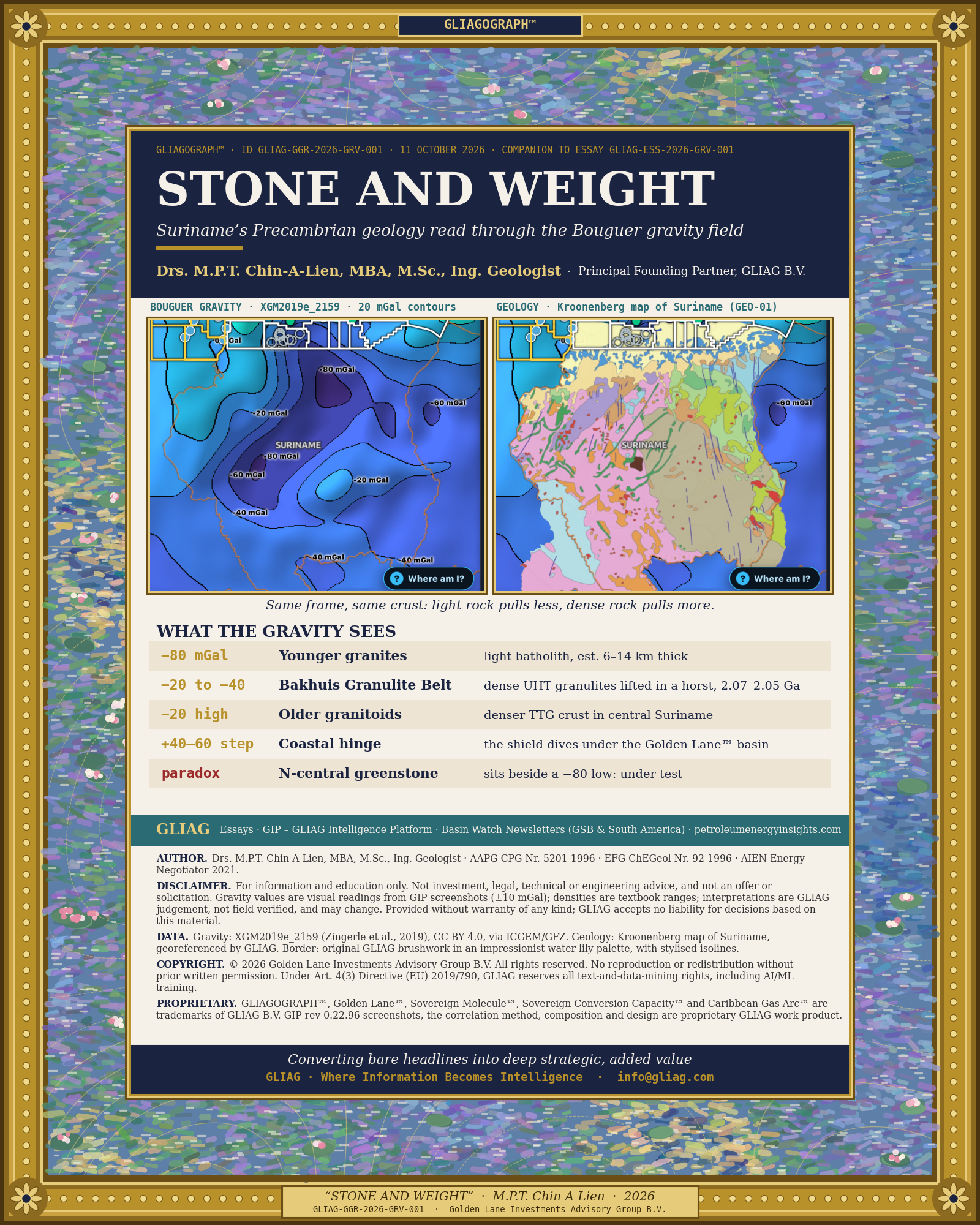
| THE FINDING Suriname’s Bouguer gravity field repeats the three-part architecture of its Precambrian basement. Over the Proterozoic shield the anomaly ranges from about −20 to −80 mGal (XGM2019e_2159, 20 mGal contours, as rendered in GIP rev 0.22.96).Light granites sit in lows. Two closed −80 mGal lows straddle the north-west, and the larger western one lies over the Younger granites. Dense high-grade crust stands up between them: the Bakhuis Granulite Belt coincides with a −20 to −40 mGal saddle. The older granitoid terrain of central Suriname carries a closed −20 mGal high.One result breaks the textbook rule: the northern −80 mGal low touches the western Marowijne Greenstone Belt, where dense metavolcanics should raise gravity. GLIAG reads this as a test of the data, not a refutation of geology.At the coast the field climbs 40–60 mGal within about 50 km. That gradient marks the hinge where the Guiana Shield dives under the Guyana–Suriname Basin, the same margin that hosts the Golden Lane™ offshore. |
1. Two maps, one crust
GIP overlays two independent datasets on the same Leaflet frame.
The geological layer is the Kroonenberg map of Suriname (GEO-01), an owner-supplied image georeferenced by GLIAG to the Natural Earth border.
The gravity layer is the Bouguer anomaly over land and sea from XGM2019e_2159 (Zingerle et al., 2019, CC BY 4.0, distributed by ICGEM/GFZ), rendered as a 301 × 251 grid with 20 mGal contours (GIP).
The basement architecture comes from Kroonenberg et al. (2016).
Their revised model divides Suriname into three metamorphic belts, separated in the centre of the country by a wide terrain of granitoids and felsic metavolcanics (Netherlands Journal of Geosciences):
• North-east: the low-grade Marowijne Greenstone Belt.
• North-west: the high-grade Bakhuis Granulite Belt.
• South-west: the high-grade Coeroeni Gneiss Belt.
This essay asks a single question: does the gravity field see that architecture?


Figure 1. Left: Bouguer gravity anomaly, XGM2019e_2159, 20 mGal contours. Right: the same frame with the Kroonenberg geological map of Suriname at 100 % opacity. Source: GLIAG Intelligence Platform rev 0.22.96, 11 Oct 2026.
2. Why gravity sees rock
A Bouguer anomaly removes the pull of latitude, elevation and the rock slab between the station and sea level.
What remains reflects lateral density contrasts in the crust and upper mantle.
Two effects add together:
• Long wavelengths, hundreds of km: crustal thickness and isostatic roots. They explain why stable shields sit at negative Bouguer values.
• Shorter wavelengths, tens of km: density contrasts between rock bodies. A large granite batholith at 2.63 g/cm³ set into crust averaging 2.75 g/cm³ produces a low of several tens of mGal. A greenstone pile of metabasalt at 2.9–3.0 g/cm³ produces a high.
The densities below are textbook ranges for each rock type (Telford et al., Applied Geophysics, 1990).
They are not measurements on Surinamese samples. [VERIFY: GMD/Staatsolie density logs]
| Rock type | Typical density (g/cm³) | Expected Bouguer signature |
| Unconsolidated coastal sediments | 1.9–2.3 | Low, if thick |
| Quartz sandstone (Roraima / Tafelberg) | 2.55–2.65 | Low, if thick |
| K-rich younger granite, felsic volcanics | 2.60–2.66 | Low |
| Tonalite–trondhjemite–granodiorite (TTG) | 2.67–2.75 | Neutral to slight high |
| Metaturbidite (Armina-type) | 2.70–2.75 | Neutral |
| Intermediate–mafic granulite | 2.80–2.95 | High |
| Metabasalt, amphibolite (Paramaka-type) | 2.85–3.00 | High |
| Dolerite, gabbro, ultramafite | 2.95–3.30 | High, but bodies are narrow |
3. Formation-by-formation correlation
The table pairs each map unit with the gravity values read from the GIP rendering at the same position.
Readings are visual, with an uncertainty of ±10 mGal, half the contour interval.
Correlation strength is GLIAG judgement.
| Unit (map legend) | Age | Observed Bouguer (mGal) | Fit with density | GLIAG reading |
| Young & Old Coastal Plain, Zanderij Belt | Holocene–Tertiary | 0 to −40 onshore; +20 offshore | Cover too thin to dominate | The signal is the shield-to-basin hinge, not the sand |
| Bakhuis Granulite Belt | 2.07–2.05 Ga (UHT) | −20 to −40 saddle between two −80 lows | Strong | Dense lower-crustal granulites uplifted in a horst |
| Younger granites (pink), west-central | ~1.98 Ga [VERIFY] | Closed −80; flanks −60 | Strong | Low-density batholith |
| Older granites / gneisses, central–east | ~2.1 Ga [VERIFY] | Closed −20 high inside −40 | Moderate | Denser TTG-type granitoids; possible buried mafic bodies |
| Marowijne Greenstone Belt (Paramaka, Armina, Rosebel) | 2.26–2.10 Ga | East: −20 to −40. North-centre: next to the −80 low | Mixed | See section 5 |
| Coeroeni Gneiss Belt, south-west | ~2.0 Ga [VERIFY] | About −40 | Neutral | Mid-crustal gneiss, no strong contrast |
| Tafelberg Formation (Roraima) | ~1.87 Ga [VERIFY] | On the −40/−60 gradient | Not resolved | Plateau too small for the grid |
| Avanavero, Käyser, Apatoe dolerites; Lucie gabbro; Bemau ultramafitite | Proterozoic–Jurassic | No discrete anomalies | Below resolution | Dykes are metres to a few hundred m wide; magnetics will resolve them |

Figure 2. Close-up of Suriname. Left: two closed −80 mGal lows and a closed −20 mGal high. Right: the Bakhuis belt (lavender) runs north-east between the lows; Younger granites (pink) underlie the western low; older granitoids (tan) carry the central high. Source: GIP rev 0.22.96.
4. Granite lows, granulite ridge
The strongest correlation in the dataset sits in western Suriname.
A closed −80 mGal low lies over the pink Younger granites west of the Tafelberg plateau.
North-east of it, the lavender Bakhuis Granulite Belt runs along a −20 to −40 mGal saddle that separates this low from a second −80 mGal low to the north.
That is the pattern density predicts.
The Bakhuis belt consists of banded intermediate and mafic granulites metamorphosed at above 1,000 °C and 0.9–1.0 GPa between 2.088 and 2.031 Ga (Geoscience Frontiers, 2020).
De Roever et al. (2003) place the belt in a north-east-trending horst that coincides with a strongly anomalous magnetic zone, bounded by long mylonitised faults (de Roever et al., 2003).
Rocks from 30–35 km depth brought up in a fault block should be heavier than the granites around them.
The gravity field agrees.
The contrast between the granite low and the granulite saddle is 40–60 mGal. For a granite body 0.10–0.15 g/cm³ lighter than its host, the infinite-slab formula (Δg = 41.9 × Δρ × t mGal, with Δρ in g/cm³ and t in km) gives a thickness of roughly 6–14 km (GLIAG calculation). That is plausible for a Paleoproterozoic batholith, and it is a first-order estimate only.
5. The greenstone paradox
Greenstone belts are classic gravity highs worldwide because of their metabasalt content.
In eastern Suriname, along the Marowijne River, the belt with its Lucie gabbro and Bemau ultramafitite bodies sits at −20 to −40 mGal. That is relatively high, as expected.
The north-central sector does not fit.
A closed −80 mGal low sits just inland of the coastal plain, partly over the western greenstone branch and its contact with the granitoid terrain.
GLIAG weighs four explanations:
• Lithology. The local greenstone is dominated by Armina metaturbidites and Rosebel sandstones, not Paramaka metabasalts. Their densities of 2.60–2.75 g/cm³ give no positive contrast.
• Hidden granite. Granitoid plutons underlie the thin greenstone cover at depth. The surface map shows the lid; gravity sees the batholith beneath.
• Deep structure. A long-wavelength effect, such as thicker crust or a mantle density change, is superposed on the shallow geology.
• Data. Over Suriname’s interior the model holds little ground gravity. XGM2019e fills short wavelengths from topography-derived information, so a local low may be partly a model artefact. [VERIFY: ground-data coverage with ICGEM/BGI]
GLIAG view: the first two together are most likely.
Only a grid-value extraction, a regional-residual separation and a check of ground-station coverage can decide.
6. The coastal hinge: where the shield meets the Golden Lane™
Along the entire coast the field climbs from −20 to −40 mGal onshore to +20 mGal offshore, and to +40 mGal farther out over the outer shelf.
The step is 40–60 mGal within roughly 50 km. The Young and Old Coastal Plain and the Zanderij Belt are too thin to cause it.
The step is the gravity expression of the continental margin.
The shield crust thins northward and denser lower crust and mantle rise under the Guyana–Suriname Basin. Offshore, the Bouguer correction replaces seawater with rock density, which raises the values further.
For petroleum this hinge matters twice:
• It brackets the onshore heavy-oil province of the coastal plain, where Staatsolie’s Tambaredjo and Calcutta fields produce from Tertiary sands sitting on the basement edge. [VERIFY: field outlines against the gradient]
• It frames the offshore fairway. GIP’s licence grid (Blocks 52, 58, 42, 63–65) sits on the positive side of the gradient, over the Golden Lane™ that runs from Stabroek eastward.
7. Rifts and dykes: the Jurassic signature
The map legend dates the Apatoe dolerite to the Jurassic, the age of Atlantic opening.
West of Suriname, the gravity field shows −40 to −60 mGal lows towards Boa Vista, where the Mesozoic Takutu Graben cuts the shield. Kroonenberg et al. (2016) note that the western greenstone branch continues into Guyana across that graben (NJG).
The Apatoe dykes and the Takutu rift belong to the same Jurassic stretching episode that prepared the passive margin offshore.
The dykes are too narrow for this gravity grid, and their record belongs to the magnetic field.
8. What GIP should add next
• Zonal statistics: extract mean, minimum and maximum Bouguer per mapped unit polygon, replacing visual readings with numbers.
• Regional–residual separation: upward continuation or a 100 km high-pass filter, to split crustal-root effects from shallow geology.
• Isostatic anomaly: an Airy-corrected layer to test whether the −80 mGal lows survive isostatic correction.
• Magnetics: an EMAG2v3 layer to trace the Bakhuis horst and the dolerite dyke swarms.
• Forward models: 2D gravity profiles across Bakhuis and the north-central low, constrained by Staatsolie and GMD density data.
• Restored geology layers: the Guiana Shield, CPRM and CGMW layers retired in rev 0.22.80, to carry the correlation into Guyana and French Guiana.
9. What would change the view
Ground-gravity coverage maps that show the −80 mGal lows rest on few or no stations would downgrade sections 4 and 5. Density measurements showing
Surinamese younger granites above 2.70 g/cm³ would weaken the batholith reading.
A residual map in which the Bakhuis saddle disappears would mean the ridge is a deep-crustal effect, not the granulites themselves.
Soso Lobi.
Ku tur mi amor y kurasón, Sjonnan.
Con todo mi alma y corazón, mis amores.
References
• Kroonenberg et al. (2016), open-access PDF, Universidade de São Paulo repository
• Kroonenberg, S.B. et al. Geology and mineral deposits of the Guiana Shield.
• Zingerle, P., Pail, R., Gruber, T., Oikonomidou, X. (2019). XGM2019e, via ICGEM/GFZ.
• Telford, W.M., Geldart, L.P., Sheriff, R.E. (1990). Applied Geophysics, 2nd ed. Cambridge University Press.
• GLIAG Intelligence Platform (GIP), rev 0.22.96, layers GEO-01 and GRV-01
GLIAG notice
1. No advice. This essay is for information and education. It is not investment, legal or technical advice. Interpretations are GLIAG judgement on public data and do not replace field verification.
2. No offer or solicitation. Nothing herein constitutes an offer to sell, or a solicitation of an offer to buy, any security, licence interest or service.
3. Independence of analysis. Prepared independently by GLIAG from the sources cited. Third-party data remain the responsibility of their publishers; XGM2019e is used under CC BY 4.0.
4. Forward-looking statements. Interpretations reflect data available on 11 October 2026 and may change as new data become available.
Copyright and intellectual property.
© 2026 Golden Lane Investments Advisory Group B.V. All rights reserved.
Pursuant to Article 4(3) of Directive (EU) 2019/790, GLIAG expressly reserves all text-and-data-mining rights, including use for AI/ML training. GIP screenshots are GLIAG proprietary work product.
Trademarks. Golden Lane™, GLIAGOGRAPH™, Sovereign Molecule™, Sovereign Conversion Capacity™ and Caribbean Gas Arc™ are trademarks of GLIAG B.V.
Converting bare headlines into deep strategic, added value
GLIAG · Where Information Becomes Intelligence
GLIAG-ESS-2026-GRV-001 · © 2026 GLIAG B.V. · page