GLIAG ESSAY · GLIAG-ESS-2026-1012-TBJ-002 · VERSION 1.0 · 12 OCTOBER 2026 · COMPANION TO GLIAGOGRAPH™ GLIAG-GGR-2026-1012-TBJ-007
The Twin on the Plunge
A fill-and-spill case for a second Tambaredjo-type heavy-oil accumulation on the seaward plunge of the Bakhuis–Tambaredjo Horst, Suriname
Drs. M.P.T. (Marcel) Chin-A-Lien, MBA, M.Sc., Ing. Geologist
Principal Founding Partner, Managing Partner & Chief Architect, Golden Lane Investments Advisory Group B.V. (GLIAG)
AAPG Certified Petroleum Geologist Nr. 5201-1996 · EFG Chartered European Geologist Nr. 92-1996 · AIEN Energy Negotiator, June 2021
Zoetermeer / Delft · Paramaribo · petroleumenergyinsights.com · GLIAG GSB Intelligence Platform™
| ABSTRACT The Tambaredjo heavy-oil complex holds about 1 billion barrels of oil in place in Paleocene sands 275–400 m deep on the Calcutta High, the coastal expression of the Bakhuis–Tambaredjo Horst (Nelson, 2016; Girjasing et al., 2019). For forty years it has had no sibling. This essay argues that the sibling exists and identifies where it should lie. Five lines of evidence converge. (1) The West–East regional 2D line from Nickerie to Paramaribo, interpreted in Prachand’s AdeKUS B.Sc. thesis under the author’s guidance, shows a single Bakhuis-type basement culmination on the coastal plain, so a twin cannot lie along strike on land. (2) Basement samples place greenstone gneiss, not granulite, under Commewijne (Girjasing et al., 2019). (3) The 1° northward regional dip (Wong, 1986) carries the Paleocene T-sand from 0.33 km at the field to about 0.85–1.35 km at 30–60 km offshore. (4) A fetch calculation shows that 1 billion barrels needs 420–830 km² of peak-yield kitchen draining to one point, which requires a basement promontory that faces the kitchen. (5) Gussow’s fill-and-spill logic implies that any closure on the seaward plunge of the same promontory received oil before Tambaredjo did.The proposed accumulation, Tambaredjo-II, is a low-relief culmination on the plunge beneath the Saramacca–Coronie inner shelf. GLIAG estimates 140–570 MMbbl STOIIP (P90–P10; P50 280 MMbbl), 16–25° API oil at 53–68 °C, and a geological chance of success of 0.33 (judgement). The main risks are closure and seal, not charge. The 0–20 m water strip between shoreline and the 2025 Staatsolie–BGP–TGS survey is the least-imaged belt in the basin and the most likely reason the twin has not been found. |

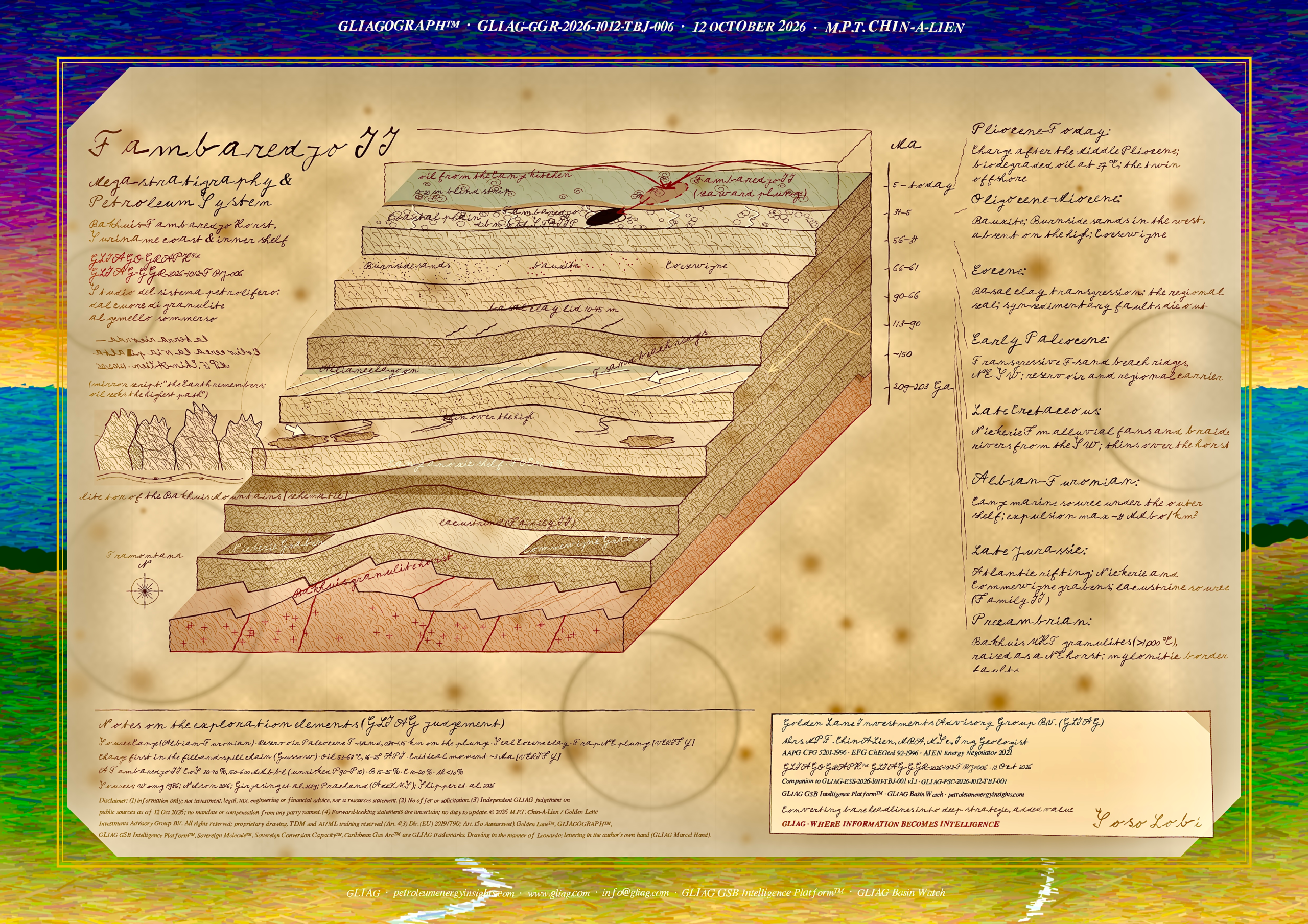
Figure 1. GLIAGOGRAPH™ GLIAG-GGR-2026-1012-TBJ-007: the Tambaredjo II mega-stratigraphy as an eight-step 4D block, drawn in the manner of Leonardo da Vinci and lettered in the author’s hand (GLIAG Marcel Hand). Each step is a time slice; its top face is the paleogeography of that interval. Schematic, not to scale.
Introduction: the question I have carried since 2008
I have wanted to find a second Tambaredjo for most of my working life in Suriname.
During my years with Staatsolie in Paramaribo (2008–2010) the question came back with every coastal seismic line I saw: a field of this size on a passive margin should not be alone.
Giant heavy-oil accumulations on shield margins tend to come in belts.
Across the same Guiana Shield, the Orinoco Heavy Oil Belt of eastern Venezuela, which I have known since my Maracaibo years, forms a continuous belt of biodegraded oil on the shield’s northern flank.
This essay sets out where I think Suriname’s twin is sitting, and why.
The argument is built in the style of a petroleum-systems paper:
the template field first, then the geological history, then the migration geometry, then the prospect, its volumes and its risks, and finally the tests that would prove it wrong.
It complements the regional screening in The Second Tambaredjo, GLIAG-ESS-2026-1011-TBJ-001 v1.1 [VERIFY: direct URL] and the potential-field work in GLIAG-ESS-2026-GRV-001 and GLIAG-ESS-2026-1011-GLPF-001.
Geologic setting
The Suriname coastal plain and shelf form the eastern part of the Guyana–Suriname Basin, a passive margin built on Paleoproterozoic crust of the Guiana Shield.
Atlantic rifting in the Late Jurassic opened the Nickerie and Commewijne grabens on the shelf (Nelson, 2016).
The overlying Cretaceous to Recent wedge thickens from about 200 m at the Marowijne mouth to about 2,000 m near Nieuw Nickerie onshore and dips north at about 1° (Wong, 1986).
The Bakhuis Granulite Belt is a NE-trending horst of ultrahigh-temperature granulites metamorphosed above 1,000 °C at 0.9–1.0 GPa, dated at about 2.07–2.05 Ga and bounded by long mylonitised faults that coincide with a strongly anomalous magnetic zone (de Roever et al., 2003; Geoscience Frontiers, 2020).
Girjasing, Kroonenberg, Ramdajal and Wong treat the shield horst and the Mesozoic–Tertiary Tambaredjo Uplift as one structure, the Bakhuis–Tambaredjo Horst, and date its aeromagnetically prominent border faults to the Trans-Amazonian orogeny (Girjasing et al., 2019).
The oil fields of Tambaredjo, Calcutta and Tambaredjo North-West sit on its coastal crest, the Calcutta High.
Data and methods
| Data | Source | Use |
| Coastal-plain stratigraphy and well correlation | Wong (1986) | Formations, facies, thickness trends, regional dip |
| Regional West–East 2D line, Nickerie–Paramaribo | Prachand, AdeKUS B.Sc. thesis (guide: M.P.T. Chin-A-Lien) [VERIFY: title, year]; Nelson (2016), Fig. 4; GeoExpro (2016), Fig. 3 | Number and position of basement culminations |
| Basement samples from coastal wells | Girjasing et al. (2019) | Basement type east and west of the high |
| Field and exploration data | Nelson (2016); SPE 104068; Dronkert & Wong; Staatsolie AR 2024 | Template parameters, Block 4 and Weg naar Zee results |
| Kitchen and expulsion model | Shipper, Mann & Pepper (2026) | Fetch calculation |
| Potential fields | GIP: XGM2019e_2159 (ICGEM); EMAG2v3 | Horst and coastal-hinge geometry |
| Shallow-offshore seismic status | energy-pedia (Nov 2025); First Break (May 2026) | Imaging gap at 0–20 m water depth |
Calculations (fetch area, geothermal gradient, depth and temperature on the plunge, volumetrics and risk) are GLIAG’s and are shown in full so that each can be checked. Inputs not taken from a cited source are labelled judgement.
The Tambaredjo template
| Parameter | Value | Source |
| Oil in place | ~1 billion bbl, three fields combined | Nelson (2016) |
| Reservoir | Paleocene T-sand, average ~5 m; 275–400 m deep; 37 °C; hydrostatic | Dronkert & Wong; SPE 104068 |
| Rock quality | Porosity up to 35%; permeability up to 1,100 mD; unconsolidated | Nelson (2016) |
| Trap | Structural highs from rejuvenated basement faults plus stratigraphic pinch-out; E–W Tambaredjo and NE–SW Broederschap strike-slip faults dying in the Upper Saramacca Fm | Dronkert & Wong; GeoExpro (2016) |
| Seal | 10–20 m continuous clay above the sands; Eocene basal clay up to 45 m regionally | Wong (2016); Wong (1986) |
| Oil | 14–16° API, biodegraded; Oil Family I, marine shale source | Dronkert & Wong; Nelson (2016) |
| Production status | 6.4 MMbbl in 2024; 104.5 MMbbl remaining reserves at 31 Dec 2024 | Staatsolie AR 2024 |
Stratigraphic evolution in eight time slices
Figure 1 reads from the front step (oldest) to the back step (youngest). Each slice below names what it contributed to the template and what it predicts on the plunge.
1 Step 1,
Paleoproterozoic (c. 2.07–2.05 Ga). The granulite keel forms and is later raised as a NE-trending horst. On the plunge: the same dense, magnetic keel should continue north beneath the coast, readable on the Bouguer and magnetic grids in GIP.
2 Step 2,
Late Jurassic. Rifting opens the Nickerie and Commewijne grabens and fixes the fault directions that later rejuvenate. Gravity modelling shows low-density sedimentary fill in both grabens (Nelson, 2016). On the plunge:inherited NE–SW and E–W faults should cut the plunge as they cut the field.
3 Step 3,
Albian–Turonian. The Canje source accumulates under the present outer shelf; NCO-1 records TOC to about 4.5–5% (Nelson, 2016). On the plunge: the kitchen lies directly down-dip.
4 Step 4,
Late Cretaceous. Nickerie Formation alluvial fans and braided rivers carry Roraima-derived sand from the south-west; the formation thins over Saramacca–Weg naar Zee, attributed to the Bakhuis Horst (Wong, 1986). On the plunge: syn-depositional thinning marks a high that was already active.
5 Step 5,
Early Paleocene. Transgression reworks the basal Saramacca sand into well-sorted NE–SW beach ridges, shoreface to the north and backshore to the south (Wong, 1986). On the plunge: the ridge belt continues seaward and thickens as accommodation grows; Nelson expects reservoir thickness and seal quality to improve northward (Nelson, 2016).
6 Step 6,
Eocene. A rapid transgression lays a basal clay up to 45 m thick, and most faults die out beneath it (Wong, 1986; GeoExpro, 2016). On the plunge: the regional lid should be thicker and more marine, which lowers seal risk but must be confirmed in wells.
7 Step 7,
Oligocene–Miocene. Bauxitisation; Burnside sands reach 80 m in BNS-1 to the west but are absent on the high; Coesewijne transgressions follow (Wong, 1986). On the plunge: the high stays sand-starved, which keeps the T-sand under a shale-rich cover.
8 Step 8,
Pliocene to present. Charge arrives after the Middle Pliocene and fills the traps; Holocene mudbanks deflect the rivers west. On the plunge: the twin sits in the 0–20 m water strip that neither land nor marine seismic has covered well.
The petroleum system
| Element or process | Timing | Evidence and confidence |
| Source | Albian–Turonian, 113–90 Ma | Canje typed to the onshore oils; expulsion maximum ~24 MMbo/km² near Block 52 (Shipper et al., 2026). High |
| Reservoir | Early Paleocene, 66–61 Ma; Eocene–Miocene secondary | Producing at Tambaredjo. High onshore, moderate on the plunge |
| Seal | Eocene, 56–48 Ma [VERIFY: stage] | Proven onshore; untested on the plunge. Moderate |
| Trap formation | Late Cretaceous–Eocene | Syn-sedimentary faulting and drape. Moderate on the plunge |
| Generation | From ~45–40 Ma on the shelf | Basin modelling [VERIFY: AAPG Memoir 123, ch. 24] |
| Migration and accumulation | After the Middle Pliocene, ~3.6 Ma to present | Critical moment ~3 Ma. Moderate |
| Preservation | Ongoing; biodegradation below ~80 °C | Explains 14–16° API onshore. High |
The system is a Canje–Saramacca (!) system in Magoon and Dow notation.
Its geometry is the essential point: a mature kitchen under the outer shelf, a 1° ramp, regional sheet sands as carriers, a regional clay lid, and one dense basement promontory facing the kitchen.
Migration and the fetch argument
Trapping 1,000 MMbbl in place requires 1,000 ÷ (24 × 0.10) ≈ 420 km² to 1,000 ÷ (24 × 0.05) ≈ 830 km² of kitchen at peak yield, if 5–10% of expelled oil is retained (GLIAG calculation on Shipper et al., 2026; retention is judgement).
That drainage is two to four times the field’s early-development footprint of about 200 km² (Dronkert & Wong).
On a 1° monocline, oil climbing the ramp converges on the crest of any basement promontory that projects toward the kitchen.
The NE–SW beach ridges and the Broederschap fault trend run parallel to strike, so oil meeting them is steered sideways toward the culmination. Tambaredjo is large because of where it stands.
Figure 2. Schematic S–N section from the outer-shelf kitchen to Tambaredjo, with Tambaredjo-II on the seaward plunge of the Calcutta High. Not to scale; GLIAG concept after Wong (1986), Nelson (2016) and Shipper et al. (2026).
The Tambaredjo-II play
Why the twin is on the plunge and not along strike
Prachand’s Naigi Nickerie–Paramaribo line, read with Wong’s well correlation, shows one Bakhuis-type culmination on the coastal plain: the section thickens west toward Nickerie and east toward Paramaribo away from the Calcutta High.
Girjasing et al. found greenstone-belt gneiss, not granulite, beneath Commewijne, and the Nickerie samples were inconclusive (Girjasing et al., 2019).
A second granulite keel is therefore not expected along strike on land.
The search turns from a West–East question into a South–North one.
Fill and spill
Gussow’s principle of differential entrapment states that, along one migration route, the down-dip trap fills first and passes oil up-dip only at spill point. Tambaredjo received about 1 billion barrels after the Middle Pliocene.
Any closure on the seaward plunge of the Calcutta High lay on the same route and received oil earlier. Unless it leaked, it should be full to spill. The burden of proof moves from charge to closure and seal.
Depth, temperature and expected oil quality
| Distance offshore of the field | T-sand depth (1° dip) | Temperature (~30 °C/km) | Expected oil (judgement) |
| 0 km (Tambaredjo) | ~0.33 km (observed 275–400 m) | 37 °C (observed) | 14–16° API (observed) |
| 30 km | ~0.85 km | ~53 °C | 16–20° API |
| 60 km | ~1.35 km | ~68 °C | 18–25° API |
The gradient follows from 37 °C at about 330 m and a mean surface temperature of about 27 °C [VERIFY]. Both offshore positions stay below the ~80 °C pasteurisation limit, reached here near 1.75 km, so the oil will still be biodegraded but less so than onshore (GLIAG calculation).
Why it has not been found
The 2007–2013 onshore campaign drilled about 160 wells and shot about 700 km of 2D, finding oil at 8–16° API in accumulations judged sub-economic (Nelson, 2016).
Those wells tested the flanks and small closures on land. After the 2012 nearshore Block 4 3D survey, four of the five wells drilled found oil (Nelson, 2016).
The 2025 Staatsolie–BGP–TGS multi-client survey covers about 2,000 km² in 20–50 m of water off Saramacca and Coronie (energy-pedia, 2025), and a further survey was planned for the third quarter of 2026 inside a 41,600 km² study area reaching from the coastline to about 70 m (First Break, 2026).
The strip from shoreline to 20 m of water remains the gap. Land crews stop at the mud; vessels need water under the keel.
Volumetrics and risk
| Input | P90 | P10 | Basis |
| Closure area | 20 km² | 40 km² | Judgement: a plunge culmination smaller than the field’s ~200 km² footprint |
| Net pay | 5 m | 9 m | T-sand average ~5 m onshore, thickening seaward (Nelson, 2016) |
| Porosity | 0.30 | 0.33 | Onshore up to 0.35 |
| Oil saturation | 0.75 | 0.78 | Judgement |
| Formation volume factor | 1.02 | 1.02 | Low-GOR heavy oil |
| STOIIP | 140 MMbbl | 570 MMbbl | P50 (lognormal) ≈ 280 MMbbl |
STOIIP = 7,758 × A (acres) × h (ft) × φ × Sₒ ÷ Bₒ. At recovery factors of 12–20%, the P50 case gives about 34–56 MMbbl recoverable (GLIAG calculation; recovery factor is judgement; Tambaredjo’s estimated ultimate recovery factor is about 20%, Nelson, 2016).
| Risk element | Probability | Reasoning |
| Source | 0.95 | Canje proven by onshore and Block 4 oils |
| Migration | 0.90 | Same route that charged Tambaredjo; fill-and-spill |
| Reservoir | 0.85 | T-sand belt continues seaward; facies change to finer shoreface is the risk |
| Trap (closure) | 0.60 | Gentle plunge; closure depends on faults and drape |
| Seal | 0.80 | Eocene clay thickens offshore; fault seal untested |
| Timing and preservation | 0.95 | Trap complete by the Eocene; charge after ~3.6 Ma |
| Geological chance of success | 0.33 | Product of the above (judgement) |
Alternatives and why they rank lower
▪ Weg naar Zee–Commewijne (0.15–0.25). Proven Lower Paleocene oil, including Central Weg naar Zee at 23.7 MMbbl STOIIP (Nelson, 2016), but on greenstone basement with no Bakhuis-scale promontory mapped and so a smaller fetch.
▪ Coronie–Nickerie flank (0.10–0.20). The thickest coastal section and the lacustrine Family II oil, but the 2007–2013 Nickerie campaign gave only marginal Cretaceous results (Nelson, 2016).
▪ Marowijne greenstone promontory (below 0.10). A gravity high reaches the coast, but cover is only ~200 m at the Marowijne mouth and lagoonal Alliance facies replace the beach sand (Wong, 1986).
What would falsify the concept
▪ No Paleocene closure on the plunge in the 2025–2026 shallow-offshore seismic and the Block 4 3D: geological chance of success falls to 0.15–0.20.
▪ Block 4 oils typed to Family II (lacustrine) rather than Family I: a separate system, which weakens the single-route fill-and-spill argument.
▪ Airborne gravity gradiometry across the coast showing the Calcutta High ending at the shoreline: the twin concept fails.
▪ A second basement spur east of the Suriname River on gravity gradiometry: Weg naar Zee–Commewijne would move up to 0.25–0.30.
The tests run from cheapest to most expensive: a GIP profile through Tambaredjo to Block 52, magnetic transforms, digitising Prachand’s line, oil–oil correlation, an airborne gravity-gradiometry survey from Coronie to Commewijne, integration of the shallow-offshore seismic, and finally one jack-up well with cores and PVT samples. All but the last cost less than one offshore well.
Conclusions
1. Tambaredjo is a fetch-area giant: about 1 billion barrels in place collected by a basement promontory from 420–830 km² of peak-yield kitchen.
2. The coastal West–East line shows only one Bakhuis-type culmination on land; the twin must be sought down-plunge to the north.
3. Tambaredjo-II, on the seaward plunge beneath the Saramacca–Coronie inner shelf, carries 140–570 MMbbl STOIIP (P90–P10) and a geological chance of success of 0.33 (GLIAG judgement).
4. Its charge risk is low because it lies first in the fill-and-spill chain; its risks are closure and seal.
5. It sits in the 0–20 m water strip, the least-imaged belt in the basin, which is the most likely reason it is still undrilled.
Acknowledgments
I thank Prachand, whose AdeKUS B.Sc. thesis on the Nickerie–Paramaribo regional line I had the privilege to guide, and the generations of Staatsolie and AdeKUS geoscientists whose published work underpins every number here. Errors of judgement are mine.
References cited
[1] Dronkert, H., and T. E. Wong, Geology of the Tambaredjo oil field, Suriname: conference abstract. OSTI 6108571
[2] de Roever, E. W. F., et al., 2003, The Bakhuis ultrahigh-temperature granulite belt (Suriname): I. Petrological and geochronological evidence for a counterclockwise P–T path at 2.07–2.05 Ga: Géologie de la France. ResearchGate
[3] energy-pedia, 29 November 2025, Suriname: Staatsolie initiates seismic study in shallow offshore. energy-pedia.com
[4] First Break, 19 May 2026, Staatsolie limited EIA for shallow offshore seismic survey. firstbreak.org
[5] GeoExpro, 2016, Suriname: new technology unlocks hydrocarbon potential. geoexpro.com
[6] Girjasing, R., S. B. Kroonenberg, R. Ramdajal, and T. E. Wong, 2019, Timing of the origin and uplift of the Bakhuis–Tambaredjo Horst, Suriname: Proceedings, 11th Inter Guiana Geological Conference, Mededeling GMD Suriname 29, p. 67–70. ResearchGate
[7] Gussow, W. C., 1954, Differential entrapment of oil and gas: a fundamental principle: AAPG Bulletin, v. 38 [VERIFY: pages].
[8] Magoon, L. B., and W. G. Dow, eds., 1994, The petroleum system: from source to trap: AAPG Memoir 60.
[9] Meyer, B., R. Saltus, and A. Chulliat, 2017, EMAG2v3: NOAA NCEI. doi:10.7289/V5H70CVX
[10] Nelson, A., 2016, Staatsolie’s VISION 2030: the contributions of petroleum geology to Surinamese society: Netherlands Journal of Geosciences, v. 95, no. 4, p. 375–392. Cambridge Core
[11] Prachand, [year VERIFY], B.Sc. thesis, Anton de Kom University of Suriname: interpretation of the regional West–East seismic line Nickerie–Paramaribo (thesis guide: M.P.T. Chin-A-Lien). [VERIFY: title]
[12] Shipper, K., P. Mann, and A. Pepper, 2026, Spatial variation in charge risk along the Guyana–Suriname margin: GeoExpro, 9 July 2026. geoexpro.com
[13] SPE 104068, 2006, Heavy-oil field development and reservoir management challenges in producing onshore shallow reservoirs in Suriname. OnePetro
[14] Staatsolie, 2025, Annual Report 2024. PDF
[15] Structural and tectonothermal evolution of the UHT Bakhuis Granulite Belt, Guiana Shield, Surinam, 2020: Geoscience Frontiers. ScienceDirect
[16] Wong, Th. E., 1986, Outline of the stratigraphy and the geological history of the Suriname coastal plain: Geologie en Mijnbouw, v. 65, p. 223–241. TNO repository
[17] Wong, Th. E., 2016, Editorial, Netherlands Journal of Geosciences special issue on Suriname. Cambridge Core
[18] Zingerle, P., R. Pail, T. Gruber, and X. Oikonomidou, 2020, The combined global gravity field model XGM2019e: Journal of Geodesy, v. 94, art. 66. doi
Related GLIAG research
▪ Stone and Weight: Geological Insights from Suriname’s Gravity Anomalies, GLIAG-ESS-2026-GRV-001.
▪ The Golden Lane™ in the Potential Field, GLIAG-ESS-2026-1011-GLPF-001.
▪ The Second Tambaredjo, GLIAG-ESS-2026-1011-TBJ-001 v1.1 [VERIFY: URL]; Tambaredjo II Petroleum Systems Chart GLIAG-PSC-2026-1012-TBJ-001.
▪ Revolutionizing Petroleum Migration in the Guyana Basin.
▪ GLIAG Basin Watch, daily GSB and South America editions; GLIAG GSB Intelligence Platform™.
About the author
Drs. M.P.T. (Marcel) Chin-A-Lien, MBA, M.Sc., Ing. Geologist is Principal Founding Partner, Managing Partner and Chief Architect of Golden Lane Investments Advisory Group B.V. (GLIAG). Born in Willemstad, Curaçao, in 1950 and trained at Leiden University, he has nearly five decades of international petroleum experience, including co-discovery of the Ceuta giant field in Lake Maracaibo and co-authorship of the 1986 Talukdar–Gallango–Chin-A-Lien paper on Maracaibo Basin generation and migration. He worked with Staatsolie in Paramaribo in 2008–2010 on Suriname’s PSC and offshore promotion and originated the term Golden Lane for the Guyana–Suriname fairway. AAPG Certified Petroleum Geologist Nr. 5201-1996 · EFG Chartered European Geologist Nr. 92-1996 · AIEN Energy Negotiator (June 2021).
Golden Lane Investments Advisory Group B.V. (GLIAG) · Zoetermeer / Delft · Paramaribo · petroleumenergyinsights.com · www.gliag.com · info@gliag.com · GLIAG GSB Intelligence Platform™ (GIP) · GLIAG Basin Watch (GSB and South America editions).
Disclaimer and legal notice
1. No advice. This essay is published for information and professional discussion only. It is not investment, legal, tax, engineering or financial advice, and it is not a resources or reserves statement under PRMS or any other standard.
2. No offer or solicitation. Nothing in this essay is an offer, invitation or solicitation to buy or sell any security, licence interest, asset or service in any jurisdiction.
3. Independence of analysis. The analysis is the independent professional judgement of the author and GLIAG, based on public sources as of 12 October 2026. GLIAG has no mandate from, and receives no compensation from, Staatsolie or any operator, partner or government named. No confidential data were used. Statements labelled judgement or [VERIFY] are marked as such.
4. Forward-looking statements. Statements on prospectivity, chance of success, volumes, oil quality and timing are forward-looking and uncertain, and may differ materially from outcomes. GLIAG undertakes no obligation to update this essay.
Copyright, proprietary rights and AI/ML opt-out
© 2026 Marcel P.T. Chin-A-Lien / Golden Lane Investments Advisory Group B.V. (GLIAG). All rights reserved. Essay GLIAG-ESS-2026-1012-TBJ-002, Version 1.0, 12 October 2026. The Tambaredjo-II concept, the fetch argument, volumetrics, risk assessment and Figures 1–2 are proprietary intellectual property of GLIAG. Reproduction requires prior written permission, except brief quotation with full attribution and a link to the original.
Text and data mining reservation. Under Article 4(3) of Directive (EU) 2019/790 and Article 15o of the Dutch Auteurswet, the rightsholder reserves all rights to text and data mining of this work, including training, fine-tuning or evaluating AI or machine-learning systems, without a written licence.
Trademarks. Golden Lane™, GLIAGOGRAPH™, GLIAG GSB Intelligence Platform™, Sovereign Molecule™, Sovereign Conversion Capacity™ and Caribbean Gas Arc™ are trademarks of GLIAG. Third-party names and data belong to their owners.
Converting bare headlines into deep strategic, added value
GLIAG · WHERE INFORMATION BECOMES INTELLIGENCE
Soso Lobi
Marcel Chin-A-Lien
GLIAG-ESS-2026-1012-TBJ-002 | © 2026 M.P.T. Chin-A-Lien / GLIAG B.V. | Proprietary |