GLIAG | GIP | SOUTH-EAST GOLDEN LANE
WEST TAPIR REVISITED
From the 2008 Tertiary Fan to the Upper Cretaceous Petroleum System of the South-East Golden Lane
A GLIAG–GIP flagship essay on exploration evolution, charge architecture, preservation and decision value
Marcel P.T. Chin-A-Lien, Drs., MBA, M.Sc., Ing. Geologist
AAPG Certified Petroleum Geologist No. 5201 | Principal Founding Partner and Chief Architect, GLIAG
17 October 2026 | Document ID: GLIAG-GIP-ESSAY-2026-1017-WTR-001 | Revision 1.0
**A dry well can be technically decisive without being geologically final.**
West Tapir constrained a Tertiary prospect in 2008.
It did not test the deeper Upper Cretaceous petroleum system that now defines the Golden Lane.
Read correctly, the well is not the end of a story but the datum from which a more powerful exploration question begins.

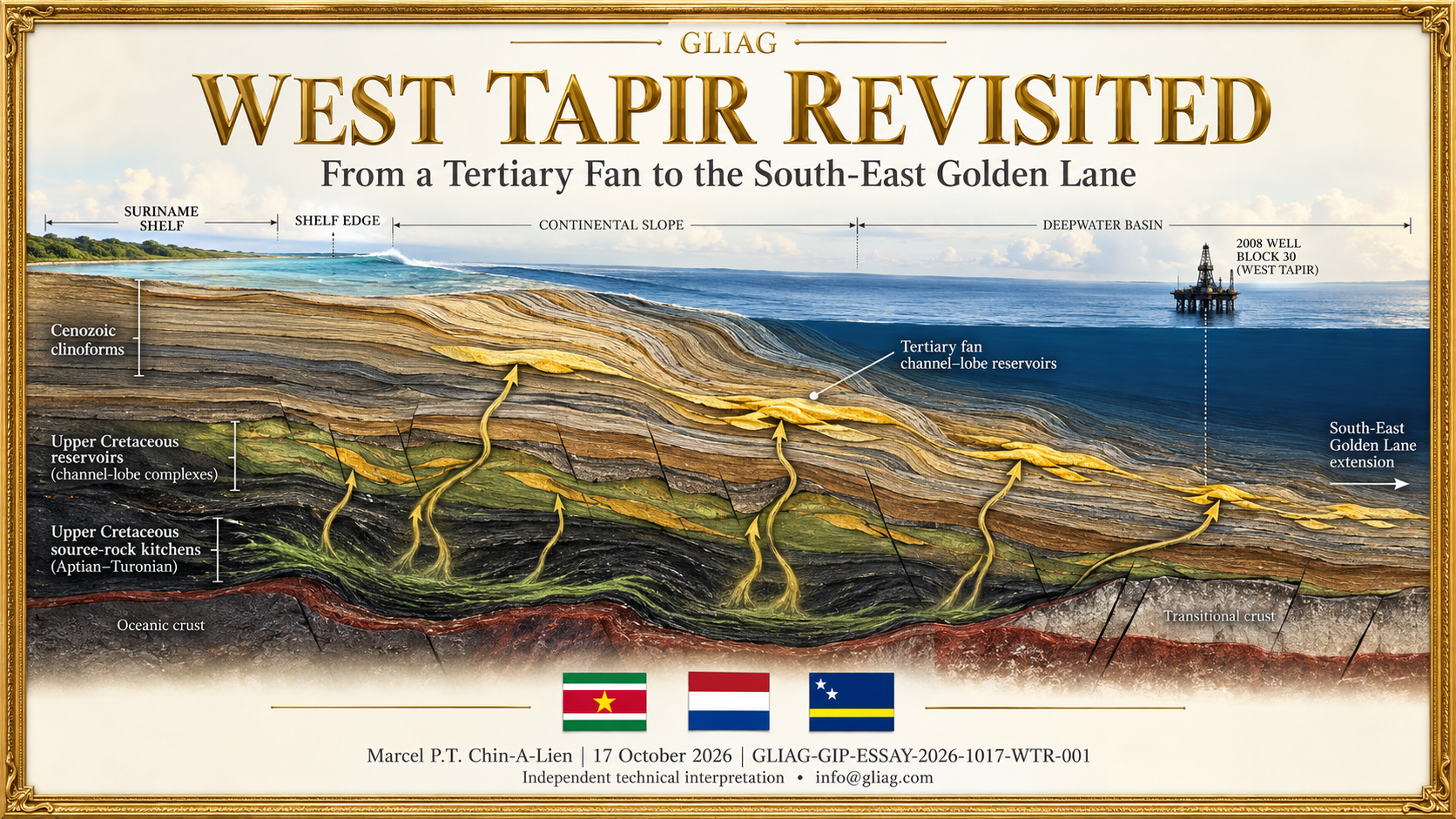
Figure 1. GLIAGoGraph—conceptual, not to scale and not a substitute for mapped seismic or well control.
It visualises the change from a shallow Tertiary fan test to an integrated source–migration–reservoir–seal–preservation view.
Golden pathways are hypotheses to be tested, not demonstrated migration routes. The depicted well position is symbolic, not geographic.
Abstract
West Tapir-1 occupies a more consequential place in the exploration history of offshore Suriname than its non-commercial result suggests.
Drilled in 2008 in former Block 30 to approximately 3,870 m below seafloor, the well targeted an Oligocene–Eocene/Tertiary prospect.
It supplied a modern stratigraphic and geophysical calibration point but did not penetrate the Upper Cretaceous petroleum system that later underpinned the commercial transformation of the Guyana–Suriname Basin.
Shawn J. Goss’s 2009 thesis, Cenozoic Seismic Stratigraphic Analysis of the Suriname Margin, South America, is therefore valuable not because it retrospectively proves a Cretaceous play, but because it reveals the overburden architecture, sediment-routing logic, unconformities, slope instability and shallow drilling risks through which any deeper play must be imaged, charged, preserved and safely drilled.
This essay repositions former Block 30 within the proposed South-East Golden Lane.
It argues that the decisive exploration unit is no longer an isolated fan-shaped amplitude or a single reservoir objective, but a four-dimensional petroleum-system corridor: source richness and maturity; expulsion history; carrier and fault connectivity; reservoir access; trap formation; seal integrity; pressure; phase; and post-charge preservation.
The central GLIAG prognosis is deliberately conditional.
The south-eastern fairway is unlikely to behave as a uniform extension of the better-known discovery corridor.
It should instead be expected to comprise segmented liquid-rich, mixed-phase and gas-condensate domains whose commercial quality is governed by the spatial overlap of charge access, reservoir presence, trap timing and preservation.
The essay also sets out the practical GLIAG–GIP–Basin Watch trident.
GLIAG supplies accountable geological judgement; GIP transforms evidence, expert judgement and reproducible analysis into decisions a client can trust; and the News Letters/Basin Watch provide the continuous signal-detection loop.
Together they shorten the path from new evidence to a ranked exploration or business-development action while retaining provenance, uncertainty and auditability.
Keywords:
West Tapir-1;
Block 30;
South-East Golden Lane;
Guyana–Suriname Basin;
Aptian; Albian–Coniacian;
charge risk; sequence stratigraphy; migration; preservation;
GIP; GLIAG; Basin Watch.
1. The well before the play—and the question after the well
Exploration history is often rewritten by later success.
Once a basin becomes prolific, older wells are either elevated into prophetic precursors or dismissed as irrelevant failures.
Both treatments are geologically weak. A well is an experiment bounded by its target, location, depth, design, data quality and pre-drill model. It can only falsify the proposition it actually tested.
West Tapir-1 returned offshore drilling to Suriname after more than two decades.
The Repsol-led well was drilled in 2008 in approximately 100 m of water, reached about 3,870 m below seafloor and was reported as dry/non-commercial. The public evidence indicates that its principal objective was Tertiary, not the deeper Upper Cretaceous slope and basin-floor system.
The disciplined conclusion is therefore narrow but powerful: the tested Tertiary prospect did not establish a commercial accumulation; the later Cretaceous play was not condemned.
That distinction was central to my earlier essay, West Tapir-1: The Well Before the Play, and to the broader histories assembled in The Evolution of Petroleum Systems in Suriname Offshore Exploration and Guyana–Suriname Basin: From Discovery to Production Success.
The present essay advances the argument.
It asks what West Tapir and the Block 30 Cenozoic architecture can contribute to a modern re-screening of the South-East Golden Lane—and what a contemporary explorer should now expect, measure and decide.
The answer begins with a change in the unit of thought. In 2008 the practical exploration object was a mapped Tertiary prospect.
In 2026 the relevant object is a coupled system extending from Cretaceous source facies through burial, expulsion, migration and reservoir access to trap timing, pressure, fluid phase and preservation.
The earlier object remains inside the new system: the Tertiary is the overburden, velocity field, seal stack, pressure architecture, drilling environment and possible secondary reservoir. It has not become irrelevant; its function has changed.
2. What the Goss thesis actually contributes
Goss (2009) analysed the Cenozoic stratigraphic evolution of the Suriname margin using the former Block 30 three-dimensional seismic volume, regional two-dimensional lines, North Coronie-1 control and Ocean Drilling Program Leg 207 Site 1257.
Seven regionally traceable surfaces—Wanica, Nickerie, Sipaliwini, Para, Marowijne, Saramacca and the Commewijne seafloor—were organised into six sequence sets using the accommodation-succession approach of Neal and Abreu.
The analysis identified a margin repeatedly reorganised by relative sea-level change and high sediment supply. Lowstands were associated with outer-shelf and slope incision, sediment bypass, mass-transport deposits and inferred turbidite accumulation.
Transgression backfilled relief; highstand packages aggraded and prograded the outer shelf, with condensed deposition farther downslope.
The Early Miocene Nickerie surface was interpreted as a major erosional unconformity, correlated regionally with the Demerara Rise “C” unconformity. Through the younger Cenozoic, the shelf edge advanced by roughly 20 km in the study area.
Those observations remain valuable at four levels.
First, they establish a routing archive. Incised shelf and slope pathways indicate where sediment and erosive flows repeatedly crossed the margin. A younger routing system cannot simply be projected into the Cretaceous, but persistent physiographic tendencies, inherited relief and depocentre migration can inform the priors used to search for older feeder-channel and lobe systems.
Second, they provide an overburden and imaging framework. Rapidly prograded, faulted and locally remobilised Cenozoic strata affect seismic velocity, illumination and depth conversion. A subtle Cretaceous closure or pinch-out can be created, shifted or erased by an imperfect overburden model. Reprocessing is therefore not cosmetic; it can alter the geometry, depth, pressure expectation and even the existence of a prospect.
Third, they reveal a preservation and pressure framework. Mass-transport complexes, normal faults, gullies, pockmark-like expressions and variable stratigraphic condensation are relevant to seal continuity, shallow hazards, leakage history and pore-pressure prediction. The thesis noted a seafloor-offsetting fault near West Tapir and recommended near-offset reprocessing, ultra-high-resolution surveying and improved well/core control. These are not footnotes. For a deeper re-entry into the area, they belong in the exploration chance map and well-design basis.
Fourth, the thesis protects against a category error. Its closing exploration model proposed that lower-slope fans, shelf-edge deltas and turbidites might contain reservoir sands capable of charge from Late Cretaceous source rocks. That is a sensible petroleum-system bridge, but it is not proof of charge at West Tapir, nor evidence that a specific Upper Cretaceous accumulation exists beneath former Block 30. The thesis is strongest when used as a calibrated Cenozoic boundary condition—not as a surrogate deep-Cretaceous dataset.
3. The intellectual migration: from fan recognition to petroleum-system architecture
The move from the West Tapir era to the present can be summarised as five linked advances.
| Exploration lens | West Tapir-era emphasis | Current Golden Lane emphasis | Decision consequence |
| Target | Discrete Tertiary fan/prospect | Stacked Cretaceous channel–lobe fairways plus selective younger objectives | Rank portfolios, not single amplitudes |
| Charge | Regional source plausibility and long-distance migration | Source-specific maturity, expulsion, fetch and carrier access | Map charge polygons independently of trap polygons |
| Seismic | Geometry recognised from 2D and early 3D | Pre-stack depth imaging, inversion, rock physics and stratigraphic geomorphology | Quantify depth, reservoir and fluid uncertainty jointly |
| Fluids | Hydrocarbon presence/absence | Oil, volatile oil, gas-condensate, biodegradation, GOR and pressure domains | Match development concept to fluid system early |
| Risk | Prospect-level chance | Coupled source–migration–reservoir–seal–timing–preservation chance | Prevent attractive reservoir images from masking charge or retention failure |
The modern framework rests on a much stronger stratigraphic and geodynamic base. ODP Leg 207 documented Cretaceous and Paleogene stratigraphy on Demerara Rise and the organic-rich record of oceanic anoxic events. Delhaye-Prat et al. (2024) integrated 2D/3D seismic, wells and high-resolution biostratigraphy into a Cretaceous sequence-stratigraphic framework and highlighted the margin’s dual-phase rift inheritance, later sediment-supply changes and Santonian development of channel-dominated turbidite fans. The Staatsolie GeoAtlas now frames Suriname acreage through basin evolution, petroleum systems, play concepts and discovered oil and gas.
Commercial evidence has changed the prior probability as well. The GranMorgu final investment decision converted Block 58 discovery into a 220,000-bopd development pathway, with commissioning targeted for 2028. In Block 52, Sloanea and subsequent successes have strengthened a distinct gas-development case. These outcomes do not de-risk former Block 30 automatically. They demonstrate that the Suriname sector can host commercially material liquid and gas systems, while simultaneously warning against a single-fluid, single-play mental model.
This evolution is developed across my own connected work: A World-Class ACT Marine Source Rock System, The Overlooked Aptian Source Rock System, Understanding Dual-Phase Petroleum Systems, SE Golden Lane: A Dual Oil and Gas-Condensate Basin, Golden Lane Basin Fluid Evolution Insights and Charge Architecture of the Guyana–Suriname Basin. Their common proposition is not that one map solves the basin. It is that source families, maturity domains, migration access, reservoir fairways and preservation must be risked separately before they are recombined.
4. Repositioning former Block 30 in the South-East Golden Lane
The term Golden Lane, as I developed it during and after my 2008–2010 Staatsolie period, denotes a systems fairway: the spatial and temporal coincidence of effective Cretaceous kitchens, migration access, deep-water reservoir delivery, marine seals, trap formation and preservation. It is not a discovery line, a political boundary or a guarantee of repetition. The Golden Lane—Guyana–Suriname Basin and The Real El Dorado of the Guyana–Suriname Super Basin set out that broader vision.
The South-East Golden Lane is the next test of the concept because the controlling variables change eastward and southward. Crustal type and heat flow evolve around the Demerara Plateau and transform-margin architecture. Sediment pathways reorganise. Source facies, thickness and maturity do not remain constant. Migration distances and carrier geometries change. Reservoir sand delivery may improve in one interval and deteriorate in another. The correct expectation is therefore segmented continuity: petroleum-system elements may persist regionally while their commercial overlap breaks into discrete sweet spots.
Former Block 30 deserves renewed attention for three reasons. It sits within a historically important transition between shelf, slope and deeper basin domains; it contains an unusually well-described Cenozoic seismic-stratigraphic framework; and its best-known well terminated above the principal later play. This combination creates an option value: not proof of a discovery, but a high-information setting in which legacy seismic and well constraints can be recombined with modern source-to-sink, basin-modelling and imaging methods.
The priority is not to “deepen West Tapir” as a slogan. It is to rebuild the regional experiment. A contemporary re-screen should ask whether mapped Cretaceous reservoir fairways are connected to one or more effective kitchens; whether carrier beds or faults connect expulsion cells to traps without simultaneously compromising seals; whether trap formation predates or overlaps charge; whether the Cenozoic overburden preserves or distorts the deeper image; and whether pressure and phase support a viable development concept.
5. The GLIAG prognosis: what to expect, why, and how to test it
The following propositions are GLIAG exploration hypotheses, not certified resources or claims of discovery. Their value is that each can be converted into an observation, model test or drilling decision.
5.1 Expect more than one source contribution
The regional record supports a rich Albian–Turonian/Coniacian marine source-rock family and a credible Aptian contribution.
Their relative thickness, facies, maturity and expulsion timing are unlikely to be uniform. Mixed-source oils, vertically separated kitchens or locally dominant Aptian charge should therefore be treated as live alternatives.
Biomarker and isotope programmes must be designed to discriminate source families rather than merely confirm “Cretaceous” affinity.
Test:
build source-specific 3D maturity and expulsion maps; calibrate them with available geochemistry, pressure, temperature and seep/occurrence data; preserve alternative kinetic cases rather than forcing a single best model.
5.2 Expect a phase mosaic, not a single oil line
The south-eastern corridor may move between oil, volatile oil, wet gas and gas-condensate domains over comparatively short distances as burial, heat flow, cracking history, migration fractionation and reservoir pressure vary. The oil success of one block and gas success of another are not contradictions; together they imply a spatially organised fluid system.
Test: couple charge timing and PVT scenarios to depth/temperature uncertainty; map expected GOR and condensate yield ranges; carry fluid uncertainty into facilities screening before appraisal, not after it.
5.3 Expect reservoir presence to be hierarchical and discontinuous
Upper Cretaceous deep-water systems should be analysed as nested fairways: regional sediment entry, slope conduits, channel complexes, lobe complexes, bedsets and baffles. A regional sand-prone trend can coexist with a dry prospect if the local element is bypassed, mud-prone, eroded or poorly connected. Conversely, modest individual bodies may become commercial when vertically stacked.
Test: use seismic geomorphology, spectral decomposition, inversion and analog-constrained net-to-gross priors; rank stacked volume and connectivity, not just gross amplitude area.
5.4 Expect preservation to become as important as generation
As exploration moves toward more structurally and thermally variable margin sectors, the question “was petroleum generated?” becomes insufficient. Fault reactivation, seal capacity, pressure cycling, top-seal lithology and post-charge tilting can determine whether generated volumes remain in a drillable trap. The Cenozoic fault and mass-transport architecture described by Goss must therefore be integrated with deep structural restoration and leakage indicators.
Test: undertake fault-seal and capillary-threshold analysis; restore trap history; compare charge pulses with deformation; map shallow gas, pockmarks and amplitude anomalies as possible evidence—never as automatic proof—of leakage.
5.5 Expect the Tertiary to return as an enabling play and risk layer
The transition to Cretaceous exploration does not erase the Tertiary. Selected younger fans may remain secondary targets; more universally, the Cenozoic section governs shallow hazards, velocity, pressure transmission, seal stacking and drilling cost. West Tapir’s most durable contribution may be precisely this calibration.
Test: reprocess the original 3D with modern deghosting, multiple attenuation, anisotropic depth imaging and near-offset preservation; integrate West Tapir logs, checkshots, biostratigraphy and pressure data where accessible; acquire targeted high-resolution hazard data.
5.6 Expect commercial sweet spots to be smaller than the geological fairway
A Golden Lane-scale petroleum system can be regionally effective while only a fraction is commercially advantaged. Water depth, reservoir deliverability, fluid quality, tie-back distance, carbon intensity, fiscal terms, market access and development phasing define a commercial polygon inside the geological polygon.
Test: couple risking to development archetypes—stand-alone FPSO, hub tie-back, gas aggregation, FLNG or phased liquids/gas development—and update value-of-information against each archetype.
6. A practical former Block 30 re-entry programme
The recommended programme is staged so that each expenditure buys a defined reduction in uncertainty.
1. Evidence reconstruction. Assemble the complete West Tapir well record, legacy 2D/3D processing histories, velocity data, biostratigraphy, pressure observations, geochemistry and licence history. Every datum receives provenance, date, spatial reference and confidence.
2. Re-image the overburden and basement context. Preserve near offsets; improve multiple suppression, anisotropy and depth conversion; test alternative velocity models across progradational wedges and mass-transport bodies; integrate gravity and magnetic constraints on crustal domains.
3. Build a Cretaceous sequence framework. Tie the Delhaye-Prat regional framework to local seismic; map feeder systems, slope confinement, channel–lobe architecture and stratigraphic termination; record interpretation alternatives.
4. Model source-specific charge. Separate Aptian and Albian–Coniacian cases; run heat-flow and kinetic ensembles; compute expulsion timing, fetch and migration access; compare against known fluid families.
5. Restore traps and seals. Date structural growth, compaction and fault motion relative to charge; evaluate top and lateral seal; model pressure and leakage scenarios.
6. Rank a portfolio, not a favourite. Use common chance definitions and dependency logic. Prevent shared charge or seal assumptions from being counted as independent across prospects.
7. Integrate commercial pathways. For each subsurface outcome, pre-screen well cost, development concept, fluid handling, infrastructure access, schedule, carbon intensity and market/fiscal exposure.
8. Design the discriminating well. The next well should resolve the largest value-bearing uncertainties, not merely target the largest unrisked volume. Sampling, pressure, fluid and geochemical acquisition must be designed before spud.
This workflow also creates business-development intelligence. It can reveal where acreage value depends on a single untested kitchen; where two licences share a migration corridor; where a gas discovery could gain value through aggregation; or where a modest oil accumulation becomes attractive through future GranMorgu-area infrastructure. The geological model becomes commercially useful without pretending that a scenario is a reserve.
7. The GLIAG–GIP–News Letters trident
The practical challenge is not lack of information.
It is the time and discipline required to turn scattered information into an accountable decision.
The three components serve different functions.
| Trident element | Primary role | Operating question | Deliverable |
| GLIAG | Expert interpretation and challenge | What does the evidence mean, what else could explain it, and what matters? | Play logic, prognosis, red-team review and decision framing |
| GIP | Evidence, model and provenance integration | Which claims are observed, inferred or modelled; how do they connect; what changes the decision? | Traceable evidence graph, scenarios, risk register and ranked actions |
| News Letters / Basin Watch | Continuous monitoring and signal detection | What changed, is it material, and which assumptions must be updated? | Dated intelligence note, impact pathway, alerts and model-update queue |
GIP is not valuable merely because it uses artificial intelligence.
Its value is that it transforms evidence, expert judgement and reproducible analysis into decisions that a client can trust.
AI accelerates search, comparison and scenario work;
GLIAG determines what the evidence means, exposes alternative explanations and remains accountable for interpretation.
In practice, a new well result, paper, licence change or project milestone enters through Basin Watch. GIP links it to the affected source, reservoir, charge, pressure, commercial or strategic assumptions.
GLIAG assesses materiality, tests rival explanations and specifies the next action.
The output can be an acreage screen, prospect-risk revision, appraisal priority, data-room question, development option or executive brief.
The advantage is understated but consequential: the interval between signal and decision contracts, while the evidential trail remains visible.
This is also why the connected essay library matters.
Essays are not marketing ornaments around a database.
They are reasoned, citable syntheses that state the current model, its limits and its implications.
As new evidence arrives, the News Letters show what changed;
GIP identifies what the change touches;
GLIAG updates the interpretation;
and the essay record preserves the evolution of thought.
8. From exploration insight to E&P and business-development action
For an E&P team, the framework supports faster but more disciplined choices across the asset cycle.
• New ventures:
compare licences on common source, reservoir, preservation, data and commercial criteria; expose correlated risks; price uncertainty explicitly.
• Exploration:
select the data or well that most changes expected value; distinguish play failure from prospect failure; retain unsuccessful wells as calibration assets.
• Appraisal:
update connectivity, fluid, pressure and development cases simultaneously; prevent subsurface optimism from outrunning facilities reality.
• Development:
translate heterogeneity and uncertainty into well count, surveillance, injection and debottlenecking options.
• Business development:
identify adjacency, tie-back, gas aggregation and infrastructure-option value; connect geological maturation to deal timing.
• National strategy:
distinguish petroleum generated, discovered, recoverable, sanctioned, produced and monetised; link each stage to realistic revenue and capability timelines.
The point is not to claim certainty.
It is to make uncertainty operational: named, located, measured where possible, connected to value and assigned to an action.
That is the standard by which an integrated platform should be judged.
9. What would falsify this vision?
A serious exploration vision states its failure conditions.
The South-East Golden Lane prognosis would be weakened by evidence that the relevant source intervals are absent, lean, immature or overmature across the required fetch; that migration pathways are ineffective or systematically breach containment;
that Cretaceous reservoir delivery bypassed the area;
that trap formation post-dates the principal charge pulse; or that fluid, pressure, water depth and development constraints destroy commercial value even where accumulations exist.
Conversely, the vision gains strength through independent convergence: source-quality and maturity calibration; oil–source correlation; mapped carrier continuity; reservoir-prone seismic facies tied to wells; pressure and phase trends consistent with basin history; and discoveries occupying predicted—not retrofitted—sweet spots. GIP should record both confirming and disconfirming evidence. A platform that remembers only successes becomes a narrative engine; one that preserves falsification becomes a decision system.
10. Conclusion: return to Block 30 with a different question
West Tapir should return to the spotlight, but not through historical inflation. The well did not discover the Golden Lane, and the Goss thesis did not image a proven Cretaceous accumulation beneath it. Their value is more exact. West Tapir constrained a Tertiary prospect and supplied a calibration point. Goss reconstructed the Cenozoic machine—incision, bypass, fan deposition, progradation, faulting, mass transport and shallow risk—through which a deeper petroleum system must be understood.
The exploration question has evolved from “is this Tertiary fan charged?” to “where do source effectiveness, expulsion timing, migration access, stacked reservoir, trap timing, seal and preservation overlap—and does that overlap support a competitive development?” In the South-East Golden Lane, the most defensible expectation is segmented continuity and fluid diversity, not mechanical repetition of the north-western success case.
Former Block 30 is therefore neither condemned ground nor a promised prize. It is a high-information opportunity for a new geological experiment. Reprocessed legacy data, Cretaceous sequence stratigraphy, source-specific basin modelling, trap restoration, pressure analysis and commercial option framing can determine whether that experiment merits a well.
The GLIAG–GIP–News Letters trident is designed for precisely this class of problem. GLIAG supplies judgement; GIP makes evidence and reasoning traceable; Basin Watch keeps the model alive. Together they convert a historical well, a valuable thesis and a rapidly evolving basin into a disciplined programme of exploration, production and strategic-commercial decisions. The objective is not louder certainty. It is better questions, earlier discrimination and more decision value from every piece of evidence.
Selected GLIAG companion essays
9. The Golden Lane—Guyana–Suriname Basin
10. A World-Class ACT Marine Source Rock System
11. The Overlooked Aptian Source Rock System
12. Understanding Dual-Phase Petroleum Systems in Guyana–Suriname
13. SE Golden Lane: A Dual Oil and Gas-Condensate Basin
14. Golden Lane Basin Fluid Evolution Insights
15. The Emerging Gas-Condensate System
16. Charge Architecture of the Guyana–Suriname Basin
17. Petroleum Systems of the Guyana–Suriname Basin
18. Exploring the Complex Petroleum Dynamics of the Guyana–Suriname Basin
Selected external references
• Delhaye-Prat, V., et al. (2024). Tectono-sedimentary evolution of the Suriname margin in the Cretaceous: A sequence-stratigraphic framework. Earth-Science Reviews, 253, 104770.
• Erbacher, J., Mosher, D.C., Malone, M.J., et al. (2004). ODP Leg 207: Demerara Rise. Ocean Drilling Program.
• Goss, S.J. (2009). Cenozoic Seismic Stratigraphic Analysis of the Suriname Margin, South America. M.Sc. thesis, Dalhousie University.
• Neal, J., & Abreu, V. (2009). Sequence stratigraphy hierarchy and the accommodation succession method. Geology, 37(9), 779–782.
• Staatsolie Hydrocarbon Institute. Petroleum Geological Atlas—GeoAtlas.
• TotalEnergies (2024). Final Investment Decision for the GranMorgu development, Block 58.
• PETRONAS (2020). Sloanea-1 hydrocarbon discovery, Block 52.
• Shipper, K., Mann, P., & Pepper, A. (2026). Spatial variation in charge risk along the Guyana–Suriname margin. GEO ExPro. This published regional model is treated here as a testable hypothesis, not as proof at Block 30.
Author’s note, disclaimer and rights
This is an independent GLIAG technical and strategic interpretation based on cited public records, the author’s research and professional experience, and clearly identified hypotheses. It is not affiliated with, commissioned by, or prepared for any operator, regulator, government, university or professional association. It is not a reserves or resources report, investment recommendation, engineering design, legal opinion or government policy. The GLIAGoGraph is conceptual and not to scale. Project status and external facts are stated as of the cited source and publication date.
© 2026 Marcel P.T. Chin-A-Lien / GLIAG. All rights reserved. Proprietary analytical work. No reproduction, redistribution, commercial extraction or use for AI training without prior written permission, except brief quotation with attribution and a link. Third-party marks and materials remain the property of their respective owners.
Suggested citation: Chin-A-Lien, M.P.T. (2026). “West Tapir Revisited: From the 2008 Tertiary Fan to the Upper Cretaceous Petroleum System of the South-East Golden Lane.” GLIAG–GIP Flagship Essay, GLIAG-GIP-ESSAY-2026-1017-WTR-001, Revision 1.0, 17 October 2026.
Contact: info@gliag.com
GLIAG-GIP-ESSAY-2026-1017-WTR-001 • © 2026 Marcel P.T. Chin-A-Lien / GLIAG