GLIAG ESSAY · GLIAG-ESS-2026-PAN-001 · 10 OCTOBER 2026 · DATA CUT-OFF 10 OCT 2026
The Arc Is Awake
Panama’s Mw 7.7 Azuero earthquake, the 2025–2026 rupture sequence from Zulia to Chocó, and a science-based prognosis of where the next large earthquake is most likely
Drs. M.P.T. Chin-A-Lien, MBA, M.Sc., Ing. Geologist
Principal Founding Partner, Managing Partner & Chief Architect, GLIAG B.V.
AAPG Certified Petroleum Geologist Nr. 5201-1996 · EFG Chartered European Geologist Nr. 92-1996 · AIEN Energy Negotiator, June 2021
Golden Lane Investments Advisory Group B.V. · Zoetermeer/Delft & Paramaribo · petroleumenergyinsights.com
| THE FINDINGAt 17:56 UTC on 9 October 2026 a Mw 7.7 strike-slip earthquake ruptured the crust beneath Panama’s Azuero Peninsula at 12.6 km depth (USGS). It is the fourth damaging rupture along the Caribbean–South America–Nazca boundary in sixteen months, after Zulia (Sept 2025, Mw 6.3), north-central Venezuela (June 2026, Mw 7.2 + 7.5) and Chocó, Colombia (Aug 2026, Mw 7.4).No institute can name the date of the next large earthquake. Published science does rank where loading is highest. Near term: the Azuero aftershock zone itself. Years to decades: the unbroken San Sebastián–El Ávila segment above Caracas and La Guaira, the northern Colombia–Ecuador trench, and Panama’s own Caribbean margin.San Francisco carries a 74 % chance of Mw ≥ 6.7 within 30 years (USGS update, September 2026). That clock runs on its own faults. Panama did not move it. |
1. Panama first
As of 10 October, Panama’s civil protection system reports no confirmed deaths and at least 27 injured (Euronews/AFP). The strongest shaking fell on a lightly populated peninsula, and that geography spared lives. It does not reduce what families in Tonosí, Pedasí, Chitré, Las Tablas, La Villa de Los Santos and Penonomé are living through.
In Los Santos Province alone, authorities counted damage to 14 homes, 5 hotels, 4 hospitals, 22 schools, 2 churches and 18 government buildings; five communities were isolated by damaged bridges, roads and landslides. In Herrera, 30 homes were partially damaged and 2 destroyed (SINAPROC, reported by The Watchers, 08:15 UTC 10 Oct). Part of the Dos Continentes Hotel and the cathedral in Penonomé collapsed. The bell tower of San Atanasio cracked, in the town where Panama’s 1821 cry of independence was raised. Health Minister Fernando Boyd reported Tonosí cut off by road damage.
USGS PAGER issued a red alert and estimated about 36,000 people exposed to severe shaking and 538,000 to very strong shaking. Emergency Operations Centre director René García counted 147 aftershocks (CNN), including an Mw 6.6 at 20:25 UTC some 14 km west of Río Grande. The Pacific Tsunami Warning Center forecast hazardous waves of 1–3 m for parts of the Panamanian coast, then ended the threat (tsunami.gov). Panama City, about 200 km from the epicentre, shook hard; SINAPROC reported no damage in the capital.
2. Why Azuero: the Panama microplate
Panama rides its own small plate. Along its southern edge the Cocos plate subducts and the Nazca plate converges obliquely; along its northern edge the Caribbean plate underthrusts it at the North Panama Deformed Belt (USGS). The 9 October focal mechanism shows left-lateral strike-slip faulting. Néstor Luque, director of the Instituto de Geociencias of the Universidad de Panamá, attributes the event to the Azuero–Soná Fault System, a network of active crustal faults that accommodates deformation inside the microplate.
Two consequences follow. First, a shallow strike-slip rupture concentrates violent shaking (up to MMI IX) close to the fault, which explains the damage pattern across Los Santos, Herrera, Coclé and Veraguas. Second, strike-slip motion moves little seafloor vertically, which is consistent with the limited tsunami. Most historical seismicity in this region sits farther west along the Panama Fracture Zone; the broader area recorded Mw 7.5 in July 1934 and Mw 7.2 in July 1962 (USGS).
3. Sixteen months, four ruptures
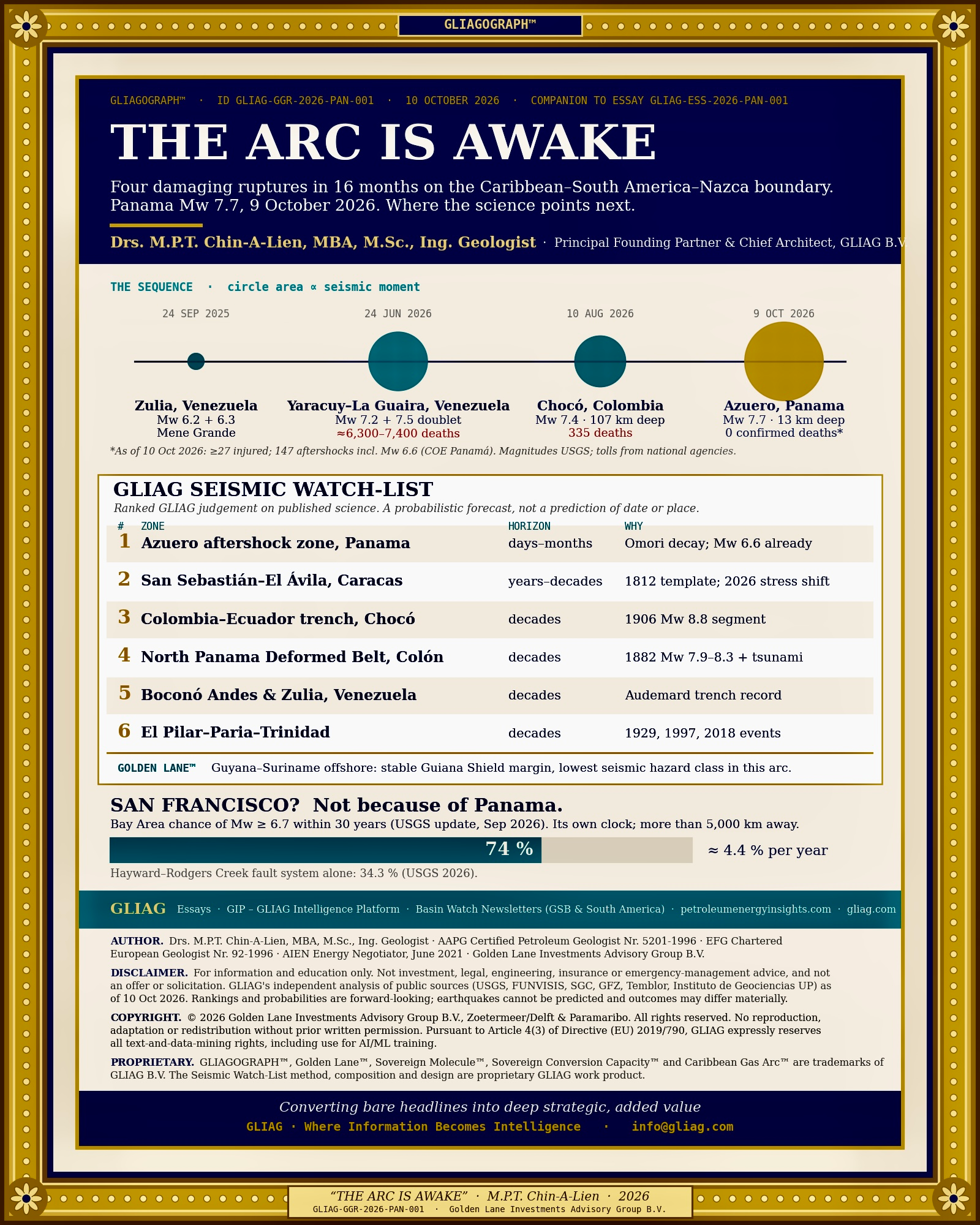
The table sets the sequence on one page. Magnitudes are moment magnitudes from USGS unless noted; tolls are the latest figures published by national agencies or compiled from them.
| Date | Location | Mw | Depth | Fault / mechanism | Human toll |
| 24 Sep 2025 | Mene Grande, Zulia, Venezuela | 6.2 + 6.3 | 8–14 km | Crustal faulting, Maracaibo block. FUNVISIS first reported 5.4 and 6.0 | 1 death, 110 injured (list) |
| 24 Jun 2026 | Yumare–Morón to La Guaira, Venezuela | 7.2 + 7.5, 39 s apart | 10–20 km | Right-lateral strike-slip: Boconó, then San Sebastián; rupture about 175 × 20 km, propagating east (USGS) | About 6,300–7,400 deaths; sources differ |
| 10 Aug 2026 | San José del Palmar, Chocó, Colombia | 7.4 (GCMT 7.5) | 96–107 km | Intermediate-depth rupture inside the subducting Nazca slab (SGC) | At least 335 deaths, more than 4,600 injured (compiled) |
| 9 Oct 2026 | Azuero Peninsula, Panama | 7.7 | 12.6 km | Left-lateral strike-slip, Azuero–Soná system (USGS) | No confirmed deaths, at least 27 injured |
Scale matters. Each step of 0.2 in magnitude doubles the energy-equivalent seismic moment. The Panama mainshock released about 2 times the moment of the Venezuelan Mw 7.5, about 1.5 times the full Venezuelan doublet, and about 125 times the Zulia Mw 6.3 (GLIAG calculation, M₀ = 10^(1.5 Mw + 9.1) N·m).
Are they linked? GLIAG judgement: not by a single mechanism. The four events sit in three tectonic regimes: dextral strike-slip on the Caribbean–South America boundary (Venezuela), intraslab failure inside the Nazca plate at about 100 km depth (Colombia), and strike-slip within the Panama microplate. Chocó and Azuero lie about 590 km apart; static stress changes from an Mw 7.4 at 100 km depth fall to negligible values long before that distance. The cluster reflects one regional fact: the Caribbean, Nazca, Cocos and South American plates converge here at roughly 1–8 cm/yr, and that budget must be paid in earthquakes. The death tolls reflect another: exposure and building vulnerability, not magnitude, decide how many people die.
4. Audemard was right about the place
For three decades Dr. Franck A. Audemard of FUNVISIS and the Universidad Central de Venezuela dug trenches across the Boconó fault. His paleoseismic work on the San Felipe segment linked that segment to the destructive 26 March 1812 earthquake that levelled Caracas, consistent with an event near Mw 7.4, and found no great rupture since. As Science reported after the doublet, his team had flagged the accumulated slip deficit as sufficient for a large earthquake (Infobae, on Science).
In 1812 two sub-events broke the Boconó fault in the west and the San Sebastián–Caracas segment in the east. On 24 June 2026 the template repeated: Mw 7.2 on the Boconó, Mw 7.5 on the San Sebastián 39 seconds later (Temblor; GFZ). One week earlier Audemard had publicly warned of unusual seismicity between 29 May and 4 June (La Jornada). After the doublet he appealed for the return of a GPS station installed in 2013 at La Chicharronera, between Morón and Barquisimeto, to track the Boconó; it had disappeared from its rock (Analítica). La Jornada reports that Venezuela’s national GPS monitoring network has been dismantled.
The lesson is exact. Field geology identified the fault, the segment and the approximate size. It could not identify the day. That is the honest ceiling of earthquake science in 2026. A second lesson follows for every government in the arc: monitoring networks that decay turn a known hazard into an unmeasured one.
5. What science can forecast, and what it cannot
No institute (USGS, FUNVISIS, SGC, GFZ or any other) predicts the date, place and size of a specific earthquake. What exists is probabilistic forecasting, built on three tools.
• Long-term hazard models. These estimate the chance of a given magnitude on a fault system over decades, from slip rates, paleoseismic records and catalogue history. The USGS California models are the reference standard.
• Operational aftershock forecasts. USGS publishes day, week, month and year probabilities for each large event, using Omori–Utsu decay and Gutenberg–Richter statistics (USGS OAF). Båth’s law puts the largest aftershock about 1.2 units below the mainshock: Mw 6.5 for Azuero. The observed Mw 6.6 fits.
• Stress transfer and geodetic locking. Coulomb models show where a rupture raised stress on neighbouring faults. Satellite radar (InSAR) and GPS show which faults are locked and storing strain. NASA’s NISAR satellite mapped the Venezuelan ground displacement within days (NASA).
One global base rate frames the question of “where next”. The planet averages about 15 earthquakes of Mw 7.0–7.9 per year (USGS long-term statistics). The next Mw 7+ somewhere on Earth is therefore likely within weeks, and most likely on a subduction zone of the western Pacific. That is a statement of rate, not a prediction.
6. The GLIAG Seismic Watch-List
The ranking below is GLIAG judgement built on the sources cited. It orders zones by the combination of documented loading and consequence. Horizons are indicative windows of elevated likelihood, not forecast dates.
| # | Zone | Horizon | Evidence | GLIAG view |
| 1 | Azuero aftershock zone, Panama | Days to months | 147 aftershocks in 24 h; Mw 6.6 already; Omori decay under way | Further Mw 6+ events plausible; the main risk is damaged buildings re-occupied too soon. Follow the live USGS forecast on the event page. |
| 2 | San Sebastián–El Ávila segment, Caracas–La Guaira | Years to decades | Coulomb model: doublet raised stress on the unbroken segment toward Caracas (Chaves et al., Temblor 2026). InSAR preprint: doublet released nearly all stored strain on Boconó and San Sebastián; El Ávila fault partly locked, up to 5 mm/yr, stress change would delay it (Research Square, Oct 2026) | Highest consequence in the arc. The two studies disagree on timing and agree on hazard. History: 1812, 1900 (Mw ~7.7 offshore), 1967 (Mw 6.5). |
| 3 | Colombia–Ecuador trench, Chocó–Darién | Decades | 1906 Mw 8.8 rupture; southern parts re-broke in 1942, 1958, 1979 and 2016 | Northern end has the longest quiet. Tsunami exposure for Buenaventura and Tumaco. [VERIFY: current coupling studies] |
| 4 | North Panama Deformed Belt, Colón | Decades | 1882 Mw 7.9–8.3 with tsunami: about 250 deaths, canal works halted (record) | 144 years since; the Atlantic entrance of the canal lies on this margin. |
| 5 | Boconó Andean segments and Maracaibo block, Venezuela | Decades | Audemard trench record of Holocene ruptures; 2025 Zulia doublet (record) | Segments south-west of the 2026 rupture remain loaded. [VERIFY: segment-by-segment dates] |
| 6 | El Pilar–Paria–Trinidad | Decades | 1929 Cumaná, 1997 Cariaco (Mw 6.9), 2018 Mw 7.3 near Sucre | Relevant to Trinidad gas and LNG and Venezuela’s eastern export terminals. |
7. San Francisco? Its own clock
The direct answer: Panama did not raise the risk in San Francisco. The two regions lie more than 5,000 km apart. Static stress changes vanish at that range, and no study has shown that a distant large earthquake brings forward a large rupture on a locked fault on any usable timescale. Remote triggering of small earthquakes by passing seismic waves is documented; triggering of a major one is not.
The Bay Area’s own numbers are high enough. In September 2026 USGS raised the 30-year probability of Mw ≥ 6.7 in the region from 72 % to 74 %, because more time has passed without a large event; the Hayward–Rodgers Creek system leads at 34.3 % (ABC7 reporting the USGS update; USGS fault map). Spread over 30 years, 74 % equals about 4.4 % per year (GLIAG calculation, Poisson assumption). USGS seismologist Dr. Lucy Jones notes it could come tomorrow or in a century. The rational response in California is retrofit and insurance, not alarm at headlines from Panama.
8. What it means for energy
Venezuela. The June doublet struck beside the Morón petrochemical complex and the 146,000 b/d El Palito refinery. Morón restarted within a day after a precautionary shutdown; El Palito lost power when transmission lines failed, idling units including its fluid catalytic cracker. Paraguaná, the Orinoco Belt and western production were unaffected, and crude exports continued from Jose, Puerto La Cruz, Amuay, Cardón and Bajo Grande (S&P Global; JOIFF). The weak link was the grid, not the plant.
Zulia. The September 2025 doublet struck Mene Grande, where Venezuela’s oil age began with Zumaque-1 in 1914, on the eastern shore of the Lake Maracaibo basin where the author helped discover the Ceuta field. Lake Maracaibo infrastructure belongs in every seismic design review.
Panama. The canal lies about 200 km from the epicentre and was already operating under El Niño draft and slot restrictions (ACP Advisory A-29-2026). Its post-earthquake inspection status, and that of the Trans-Panama oil pipeline in the west, should be confirmed with the operators. [VERIFY: ACP and Petroterminal de Panamá statements]
Golden Lane™. The Guyana–Suriname Basin sits on the passive margin of the Guiana Shield, far from the plate boundary, and carries the lowest seismic hazard in this arc (GLIAG judgement on regional hazard models). Trinidad’s LNG trains and the planned Caribbean Gas Arc™ links sit closer to the El Pilar–Warm Springs system and need seismic criteria written into their design basis from day one.
9. What would change the view
• A revised USGS aftershock forecast showing rising Mw 7+ probability, or aftershocks migrating toward the North Panama Deformed Belt or the Panama Fracture Zone.
• Finite-fault models showing the Azuero rupture stopped against a locked, unruptured segment.
• Peer review of the El Ávila locking study, and restored GPS coverage on the Boconó and San Sebastián faults.
• New coupling models for the northern Colombia–Ecuador trench from the SGC and partner institutes.
For Panama, and for the arc
This essay is written for the families of Tonosí, Pedasí, Chitré, Las Tablas, Los Santos and Penonomé; for Caracas and La Guaira, still rebuilding since June; for Cali, Pereira and the towns of Risaralda, where Pereira and La Virginia hold a place in the author’s own life. The earth along this arc will move again. The work that matters now is clearing roads to Tonosí, inspecting schools before children return, and keeping the seismographs running.
Soso Lobi.
Sources and observatories
• USGS event page, M 7.7 Pitaloza Arriba, Panama (us6000u18k)
• USGS event page, M 7.5 Venezuela, 24 June 2026 (us6000t7zp)
• USGS Landslide Hazards: 2026 Venezuela sequence
• USGS Aftershock Forecast overview
• USGS San Francisco Bay region fault probabilities
• FUNVISIS, Fundación Venezolana de Investigaciones Sismológicas
• Servicio Geológico Colombiano (SGC)
• GFZ Helmholtz Centre for Geosciences, status report on Venezuela
• European-Mediterranean Seismological Centre (EMSC)
• NOAA/NWS Tsunami Warning Centers
• Instituto de Geociencias, Universidad de Panamá (statements via national media) [VERIFY link]
• Chaves et al. (2026), Venezuela’s doublet leaned toward Caracas, Temblor
• Research Square preprint (Oct 2026): doublet strain recovery and El Ávila fault
• Audemard, F.A., paleoseismic assessment of the San Felipe segment, Boconó fault
• NASA Earth Observatory, NISAR displacement over Venezuela
• Risk Frontiers, the 24 June 2026 Venezuela doublet
• Seismosoft, preliminary report on the 10 August 2026 Colombia earthquake
• S&P Global Commodity Insights, Venezuela oil facilities after the earthquakes
• Panama Canal Authority, Advisory A-29-2026
GLIAG notice
1. No advice. This essay is published for information and education. It is not investment, legal, engineering, insurance or emergency-management advice. Seismic safety decisions belong to competent national authorities (SINAPROC, FUNVISIS, SGC, USGS and their peers) and to qualified engineers.
2. No offer or solicitation. Nothing herein constitutes an offer to sell, or a solicitation of an offer to buy, any security, asset or service.
3. Independence of analysis. The analysis, rankings and judgements are GLIAG’s own, prepared independently from the public sources cited. Third-party data remain the responsibility of their publishers.
4. Forward-looking statements. Probabilities, horizons and rankings are forward-looking and rest on sources available on 10 October 2026. Earthquakes cannot be predicted; actual events may differ materially from any scenario described.
Copyright and intellectual property. © 2026 Golden Lane Investments Advisory Group B.V. All rights reserved. No part of this work may be reproduced or redistributed without prior written permission. Pursuant to Article 4(3) of Directive (EU) 2019/790, GLIAG expressly reserves all rights to text and data mining of this work, including its use for training, fine-tuning or evaluating artificial-intelligence and machine-learning systems.
Trademarks. Golden Lane™, GLIAGOGRAPH™, Sovereign Molecule™, Sovereign Conversion Capacity™ and Caribbean Gas Arc™ are trademarks of GLIAG B.V.
Converting bare headlines into deep strategic, added value
GLIAG · Where Information Becomes Intelligence
GLIAG-ESS-2026-PAN-001 · © 2026 GLIAG B.V. · page