GLIAG N.V. — GOLDEN LANE INVESTMENTS ADVISORY GROUP
STRATEGIC PETROLEUM INTELLIGENCE PLATFORM
PETROLEUM SYSTEMS OF THE SOUTHERN CARIBBEAN GATEWAY
Maracaibo Basin · Falcón–La Vela Basin · Aruba · Curaçao · Bonaire
From a world-class Upper Cretaceous charge province to frontier offshore Oligocene–Miocene carbonate and clastic play concepts
By Drs. Marcel P. T. Chin-A-Lien, MBA, M.Sc., Ing., CPG (AAPG), EurGeol (EFG)
Principal Founding Partner & Chief Architect, GLIAG N.V.
Publication ID: GLIAG-SCPS-2026-001 · 29 July 2026 · Delft, The Netherlands
Disclaimer, Proprietary Rights, Copyright and Non-Reliance Notice
1. Publication and Scientific Disclaimer
This publication is an independent regional petroleum-systems synthesis prepared for strategic intelligence, geological education and high-level exploration screening. It is based on public-domain literature, published maps, academic studies, company disclosures and the author’s professional experience. It does not replace proprietary seismic interpretation, well-log analysis, laboratory geochemistry, pressure data, petrophysics, reservoir engineering, geomechanics, basin modelling, economic evaluation or competent-person certification. No statement herein constitutes proof of a working petroleum system in Aruba, Curaçao or Bonaire.
2. Proprietary and Confidential Intellectual Work
The analytical architecture of this publication—including the five-area comparison, petroleum-system risk hierarchy, regional charge logic, analogy ranking, migration framework, maps, diagrams, tables, captions, terminology, GLIAGoGRAPH™, conclusions and strategic recommendations—is proprietary intellectual work of Drs. Marcel P. T. Chin-A-Lien and GLIAG N.V. Disclosure of this publication does not waive proprietary rights. No recipient acquires any licence, ownership interest or right of commercial exploitation by receiving, reading, downloading, quoting or linking to this work.
3. Copyright, Database Rights and Prohibition on Derivative Use
© 2026 Drs. Marcel P. T. Chin-A-Lien / GLIAG N.V. All rights reserved worldwide. Except for brief, accurately attributed quotations permitted by applicable law, this publication may not be copied, scraped, harvested, reproduced, translated, adapted, repackaged, reformatted, distributed, sold, licensed, trained into a commercial knowledge product, incorporated into prospect marketing, acreage promotion, investor material, governmental submissions, consulting reports, artificial-intelligence datasets or derivative analytical frameworks without prior written permission. The curated selection, arrangement and annotation of sources in the Annex are additionally protected as an original compilation and, where applicable, by database rights.
4. Attribution and Moral Rights
Any authorised quotation must identify the author in full and cite the publication title, publication ID, date and GLIAG N.V. The author asserts all applicable moral rights, including the right of attribution and the right to object to distortion, mutilation, misleading extraction or use that reverses, weakens or misrepresents the scientific conclusions.
5. No Reserves, Resources, Valuation or Investment Opinion
This document is not a reserves or resources report under SPE-PRMS, SEC, NI 51-101, SAMREC, JORC or any other reporting code. It expresses no estimate of hydrocarbons initially in place, recoverable volumes, probability of geological success, commerciality, asset value, fiscal value or investment return for Aruba, Curaçao or Bonaire. References to potential plays are geological hypotheses, not discoveries, prospects, contingent resources or reserves.
6. Non-Reliance and Limitation of Liability
Readers must conduct their own technical, legal, fiscal, environmental and commercial due diligence. Neither the author nor GLIAG N.V. accepts liability for decisions, losses, claims or consequences arising from reliance on this publication, including acreage acquisition, drilling, financing, licensing, policy, litigation or investment decisions. Scientific interpretations may change when new seismic, well, geochemical, chronological or tectonic data become available.
7. Third-Party Sources and Hyperlinks
External publications, maps, reports, institutional pages and company materials remain the property of their respective owners. Hyperlinks are provided for verification and scholarly convenience; inclusion does not imply endorsement, and GLIAG N.V. does not control the continued availability or later modification of third-party content.
Executive Verdict
The southern Caribbean gateway is a connected tectonic corridor, but it is not a single, laterally transferable petroleum province. Maracaibo is the proven charge benchmark: its Upper Cretaceous La Luna system demonstrates exceptional source quality, regional maturation, long-distance migration and repeated trap filling. Falcón–La Vela is the strongest intermediate analogue because it contains real petroleum kitchens, Oligocene–Miocene clastic and carbonate reservoirs, structural compartmentalisation and the giant Perla gas accumulation. Aruba, Curaçao and Bonaire occupy the same regional plate-boundary neighbourhood, yet their exposed onshore geology is dominated by uplifted Caribbean igneous basement and discontinuous Cenozoic cover. Their credible opportunity, where one exists, lies principally offshore in buried depocentres that may preserve source, reservoir and seal intervals removed by uplift or never deposited on the islands.
The exploration proposition is therefore asymmetrical. Maracaibo proves the regional capacity to generate and migrate hydrocarbons; Falcón proves that younger, structurally complex basins can host commercial oil and gas; the ABC islands remain frontier tests of preservation, source presence, maturity, migration access and trap timing. The decisive question is not whether carbonate or clastic reservoirs can occur. It is whether a complete and correctly timed petroleum system survived offshore.
Author’s Foundational Maracaibo Contribution
Marcel P. T. Chin-A-Lien co-authored the integrated study “Generation and migration of hydrocarbons in the Maracaibo Basin, Venezuela: An integrated basin study,” developed from work presented in 1985 and published in Organic Geochemistry in 1986 with Suhas Talukdar and Oswaldo Gallango. The paper identified the La Luna Formation as the principal source system and integrated geochemistry, burial history, thermal maturation and migration. It remains highly cited and is directly relevant to the present regional framework because it demonstrates how source quality alone is insufficient: tectonic burial, kitchen development, carrier architecture and trap timing determine whether charge becomes accumulation. Official DOI record
1. Regional Tectonic Architecture: Connected, but Not Equivalent
Northern South America records the interaction of the Caribbean plate with the South American margin, superimposed on older passive-margin stratigraphy and later Andean loading, strike-slip deformation, transpression, transtension, uplift and inversion. The Maracaibo Basin evolved into a highly charged intermontane–foreland system. Falcón and La Vela developed as complex pull-apart and transtensional depocentres later modified by inversion. The Leeward Antilles expose fragments of the Caribbean Large Igneous Province and arc-related assemblages, locally overlain by younger sedimentary cover. Similar present-day geography therefore conceals materially different burial histories.
The correct exploration method is tectonostratigraphic partitioning. Each area must be tested independently for: (i) preserved source facies; (ii) sufficient burial and heat flow; (iii) migration pathways; (iv) reservoir distribution and diagenesis; (v) seal continuity; (vi) trap formation before or during charge; and (vii) preservation through uplift and fault reactivation.
2. Maracaibo Basin: The Proven Regional Charge Benchmark
2.1 Source-rock system
The Upper Cretaceous La Luna Formation is the basin’s dominant oil-prone source interval. Its organic-rich calcareous shales and argillaceous limestones contain predominantly marine Type II organic matter and locally exceptional original richness. The Chin-A-Lien–Talukdar–Gallango integrated study demonstrated that source quality, maturity and migration must be reconstructed through the basin’s structural and thermal history, rather than inferred from present-day depth alone.
2.2 Reservoirs, seals and traps
Maracaibo production is distributed through a vertically extensive system that includes Cretaceous carbonates and major Paleogene–Neogene siliciclastic reservoirs. Regional and intraformational shales provide seals, while anticlines, inversion structures, fault closures, stratigraphic traps and combination traps create a diversified portfolio. The basin’s giant accumulations reflect repeated access to charge, not a single reservoir or trap style.
2.3 Migration significance
Maracaibo is especially valuable as a migration laboratory. Generated petroleum moved vertically and laterally from mature kitchens into traps of different ages and stratigraphic positions. This establishes a regional principle: hydrocarbons can migrate far from source, but only where carrier systems, fault behaviour and pressure architecture provide access. Applying the Maracaibo analogy to the ABC islands therefore requires demonstration of an offshore kitchen and a viable migration pathway—not merely proximity on a map.
3. Falcón–La Vela: The Critical Intermediate Analogue
The Falcón–La Vela system occupies the analytical bridge between prolific Maracaibo and the frontier offshore flanks of Aruba and Curaçao. Its Cenozoic depocentres contain marine and mixed source intervals, syn-tectonic siliciclastics, carbonate platforms and build-ups, regional shales, fault blocks, drapes and inversion structures. Petroleum occurrence is heterogeneous because structural segmentation produced multiple kitchens, migration routes and preservation domains.
3.1 Perla and the carbonate-gas benchmark
The Perla discovery in the Gulf of Venezuela proves that large gas volumes can be trapped in Miocene carbonate reservoirs within the broader Falcón–La Vela domain. Its importance for Aruba is conceptual rather than directly predictive. Perla validates the regional existence of high-quality carbonate reservoir development, gas charge and effective trapping; it does not establish continuity of the same reservoir, source or pressure system beneath Aruba. Paleogeography, subsidence, facies belts, diagenesis and fault compartmentalisation must be reconstructed independently.
3.2 Why Falcón is stronger than a simple island analogy
Falcón contains preserved sedimentary thickness, mature kitchens and proven accumulations. Aruba, Curaçao and Bonaire expose uplifted basement and incomplete cover. Consequently, Falcón is the closest process analogue for potential offshore Oligocene–Miocene plays, whereas island outcrops are mainly constraints on uplift, erosion, provenance and structural history.
4. Aruba: The Offshore Preservation Hypothesis
Aruba’s onshore geology does not demonstrate a commercial petroleum system. The island is dominated by Late Cretaceous igneous basement and associated intrusive and volcanic rocks, with discontinuous younger cover. This weakens any claim that the island itself is a direct outcrop analogue of Perla or the productive Falcón Basin.
4.1 Credible offshore play families
• Carbonate-bank play: Oligocene–Lower Miocene carbonate platforms or isolated build-ups developed on structural highs, sealed by marine shales.
• Syn-rift clastic play: fault-controlled siliciclastic wedges deposited in half-grabens, with tilted blocks and updip pinch-outs.
• Miocene clastic play: younger shoreface, deltaic or gravity-flow reservoirs sourced from the Venezuelan margin and reworked along the shelf.
• Basement-flank combination play: drape, onlap and fault closure against structural highs, contingent on seal integrity and charge access.
4.2 Principal risks
The dominant risks are source presence, organic facies, maturity, migration access and timing. Reservoir presence is plausible but secondary. An excellent carbonate body without charge is sterile; a mature source without a carrier or seal is non-commercial. Aruba therefore requires modern deep seismic imaging, gravity–magnetic integration, seep and seabed geochemistry, heat-flow calibration, sequence-stratigraphic mapping and 3-D basin modelling before prospect-level confidence is defensible.
5. Curaçao and Bonaire: Useful Geological Constraints, Unproven Petroleum Provinces
Curaçao and Bonaire share elements of Caribbean plateau and arc history with Aruba, but each island has its own uplift, faulting, cover and offshore-basin geometry. Onshore sedimentary remnants provide age, provenance, paleoenvironmental and structural information; they do not prove effective offshore kitchens. Curaçao’s Seroe Domi and related Neogene successions are particularly important for reconstructing siliciclastic delivery, carbonate development and changing marine conditions. Bonaire provides additional constraints on regional uplift, carbonate terraces and basin-margin evolution.
The frontier case for both islands is therefore offshore and data-driven. Potential plays could occur in preserved fault-bounded depocentres, but any transfer of Maracaibo or Falcón parameters must be explicitly downgraded from direct analogue to tectonostratigraphic proxy until wells and geochemistry establish source, maturity and charge.
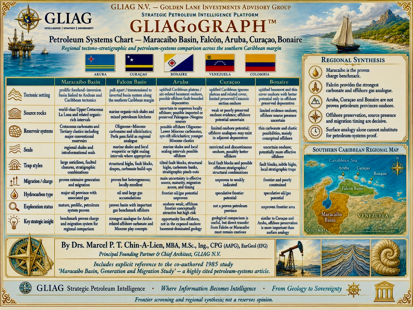
6. Source-to-Trap Comparison
| Element | Maracaibo | Falcón–La Vela | Aruba | Curaçao | Bonaire |
| Source | Proven world-class La Luna; additional younger sources | Proven but spatially heterogeneous Cenozoic kitchens | Unproven offshore; preservation and maturity unknown | Weak onshore evidence; offshore uncertain | Limited onshore evidence; offshore uncertain |
| Reservoir | Cretaceous carbonates; major Paleogene–Neogene clastics | Oligocene–Miocene carbonates and clastics; Perla analogue | Conceptual offshore carbonates, syn-rift and Miocene clastics | Limited onshore; conceptual offshore clastic/carbonate intervals | Thin onshore cover; conceptual offshore intervals |
| Seal | Regional and intraformational shales | Marine shales and local tight intervals | Possible offshore marine shales | Discontinuous onshore; potentially better offshore | Uncertain onshore; potentially better offshore |
| Trap | Anticlines, inversion, faults, stratigraphic combinations | Fault blocks, drapes, inversion, carbonate build-ups | Tilted blocks, highs, banks, onlap and pinch-out | Fault and stratigraphic combinations offshore | Fault blocks, subtle highs and stratigraphic traps |
| Charge | Proven extensive generation and migration | Proven but compartmentalised | Highest uncertainty | Unproven | Unproven |
| Status | Mature giant province | Proven oil and gas basin | Frontier offshore hypothesis | Frontier offshore hypothesis | Frontier offshore hypothesis |
7. Petroleum-System Timing: The Controlling Discipline
Every regional comparison must be reduced to an event chart. Source deposition, burial, maturation, expulsion, carrier activation, reservoir deposition, seal development, trap formation, uplift and fault reactivation must overlap in the correct order. Maracaibo demonstrates successful timing at basin scale. Falcón demonstrates local success amid structural complexity. The ABC islands remain unresolved because offshore burial histories and kitchen locations are poorly constrained. A prospect should not advance merely because a reservoir analogue exists; it should advance only when the full source–migration–trap sequence is internally coherent.
8. GLIAG Exploration Programme
1. Regional data audit: inventory all legacy seismic, wells, dredge samples, gravity, magnetics, heat-flow measurements and geochemical surveys.
2. Modern imaging: acquire or reprocess long-offset broadband 2-D seismic tied across Aruba, Curaçao, Bonaire, Falcón and Gulf of Venezuela structural domains.
3. Petroleum-system atlas: map source-risk fairways, burial domains, carbonate platforms, clastic entry points, seals, faults and trap timing.
4. Geochemistry: conduct calibrated seep, piston-core, sediment-gas and biomarker studies with strict contamination control.
5. Chronostratigraphy: integrate biostratigraphy, strontium isotopes, radiometric dating and sequence stratigraphy to constrain Oligocene–Miocene paleogeography.
6. Basin modelling: build multiple heat-flow and erosion scenarios; quantify maturity, expulsion windows and migration access rather than using a single deterministic model.
7. Prospect maturation: rank opportunities through play chance, common-risk-segment maps and explicit analogue quality.
8. Governance: market uncertainty honestly; do not promote frontier acreage as a proven extension of Perla or Maracaibo.
9. Strategic Conclusion
The southern Caribbean margin contains a hierarchy of evidence. Maracaibo is proven; Falcón–La Vela is proven but compartmentalised; Aruba, Curaçao and Bonaire are frontier. The regional geological connection is real, yet commercial continuity is not. The most defensible exploration thesis is that offshore depocentres around the ABC islands may preserve Oligocene–Miocene petroleum-system elements absent or eroded onshore. That thesis deserves disciplined investigation, not promotional certainty.
The enduring lesson from the 1985–1986 Maracaibo generation-and-migration work is equally applicable today: petroleum accumulations are the product of an integrated dynamic system. Source richness, burial, temperature, expulsion, migration, reservoir, seal, trap and preservation must be solved together. Where information is fragmented, GLIAG’s task is to convert it into a testable petroleum-system model—where information becomes intelligence.
Annex A — Clickable Bibliography and Source Intelligence Register
Each entry contains a direct clickable hyperlink and a short content line identifying its relevance. Links were selected for scientific authority, primary-source value or direct relevance to the regional petroleum-system synthesis.
1. Talukdar, S.; Gallango, O.; Chin-A-Lien, M. (1986). Generation and migration of hydrocarbons in the Maracaibo Basin, Venezuela: an integrated basin study. [Open source]
Foundational integrated geochemical, burial-history and migration study; identifies the La Luna Formation as the principal source system and directly records Marcel P. T. Chin-A-Lien’s co-authorship.
2. Gallango, O.; Talukdar, S.; Chin-A-Lien, M. (1985). Características de los crudos marinos en la Cuenca de Maracaibo, Venezuela Occidental. [Open source]
Venezuelan Geological Congress contribution on marine crude-oil characteristics; bibliographic record appears in James’s authoritative Venezuelan hydrocarbon synthesis.
3. Talukdar, S.; Gallango, O.; Chin-A-Lien, M. (1985). Generation and migration of hydrocarbons in the Maracaibo Basin, Venezuela — Bolivarian Symposium abstract. [Open source]
Conference-stage record preceding the 1986 Organic Geochemistry paper; confirms the 1985 presentation lineage.
4. Talukdar, S.C.; Marcano, F. (1994). Petroleum systems of the Maracaibo Basin, Venezuela. AAPG Memoir 60. [Open source]
Definitive petroleum-system chapter integrating source, reservoir, overburden, trap formation and charge.
5. AAPG Explorer (2026). Geology of the Maracaibo Basin. [Open source]
Recent AAPG historical review connecting classic Maracaibo literature with contemporary exploration interest.
6. James, K.H. (2000). The Venezuelan Hydrocarbon Habitat, Part 1: Tectonics, Structure, Palaeogeography and Source Rocks. [Open source]
Wide-ranging synthesis of Venezuelan tectonics, paleogeography and source-rock systems, including references to Chin-A-Lien’s work.
7. James, K.H. (2000). The Venezuelan Hydrocarbon Habitat, Part 2: Hydrocarbon Occurrences and Regional Petroleum Systems. [Open source]
Companion synthesis of accumulations, basin habitat and regional petroleum-system distribution.
8. González de Juana, C.; Iturralde de Arozena, J.M.; Picard, X. Geología de Venezuela y de sus Cuencas Petrolíferas. [Open source]
Classic multi-volume geological reference on Venezuela and its petroleum basins.
9. Magoon, L.B.; Dow, W.G. (eds.) (1994). The Petroleum System — From Source to Trap. AAPG Memoir 60. [Open source]
Foundational AAPG petroleum-system methodology used to structure source, reservoir, seal, overburden, trap and process analysis.
10. Pindell, J.; Kennan, L. (2009). Tectonic Evolution of the Gulf of Mexico, Caribbean and Northern South America. [Open source]
Plate-tectonic framework for reconstructing the Caribbean–South American boundary and regional basin evolution.
11. Villamil, T.; Pindell, J. (1998). Mesozoic paleogeographic evolution of northern South America. [Open source]
Sequence-stratigraphic and paleogeographic foundation for Cretaceous source and reservoir development across northern South America.
12. Mann, P. (ed.) (1999). Caribbean Basins. Sedimentary Basins of the World, Volume 4. [Open source]
Regional tectonic and sedimentary-basin reference covering the Caribbean plate boundary and adjacent petroleum provinces.
13. Audemard, F.A.; Audemard, F.E. (2002). Structure of the Mérida Andes, Venezuela. [Open source]
Constrains Andean deformation, foreland loading and inversion relevant to Maracaibo burial and structural evolution.
14. Escalona, A.; Mann, P. (2011). Tectonics, basin subsidence mechanisms, and paleogeography of the Caribbean–South American plate boundary zone. [Open source]
Modern basin-scale synthesis relevant to Falcón, Gulf of Venezuela and the Leeward Antilles.
15. USGS (1980). A Review of the Geology of Petroleum in Venezuela. [Open source]
Government geological review with maps and basin-level petroleum context.
16. USGS World Energy Assessment: Maracaibo Basin Province. [Open source]
Assessment framework and province-level geological description for Maracaibo.
17. Beets, D.J.; Metten, J.; Hoogendoorn, R.M. (1996). Geological Map of Aruba. [Open source]
Foundational detailed geological mapping of Aruba and its basement-dominated onshore geology.
18. TNO Geological Map of the Kingdom of the Netherlands. [Open source]
Official harmonised geological overview for Aruba, Curaçao and Bonaire.
19. Dutch Caribbean Nature Alliance — Geological background of Aruba, Bonaire and Curaçao. [Open source]
Accessible institutional context on island geology, geomorphology and natural setting; supplementary rather than primary petroleum evidence.
20. Repsol — Perla field and Cardón IV development information. [Open source]
Company disclosure documenting production start and commercial significance of the giant Perla offshore gas field.
21. Eni — Perla gas field / Cardón IV project disclosures. [Open source]
Operator-partner disclosure on Perla’s development and regional gas importance.
22. AAPG Search and Discovery. [Open source]
Repository for petroleum-geoscience papers, abstracts, field analogues and regional presentations; useful for targeted follow-up research.
23. Petroleum & Energy Insights — Drs. Marcel P. T. Chin-A-Lien / GLIAG strategic publication platform. [Open source]
Primary website containing the author’s petroleum, energy, Venezuela, Guyana–Suriname, geological and strategic intelligence publications.
Annex B — GLIAG Evidence and Analogy Ranking
| Rank | Definition | Application |
| A — Direct evidence | Well, core, fluid, geochemical, seismic or production evidence from the evaluated basin. | Maracaibo and Falcón petroleum systems; Perla accumulation. |
| B — Direct age–facies analogue | Comparable age, facies and tectonic position with demonstrated petroleum relevance. | Selected Falcón Oligocene–Miocene carbonate and clastic intervals. |
| C — Depositional or tectonostratigraphic proxy | Comparable process but uncertain continuity, source or burial history. | Potential offshore ABC carbonate banks and fault-bounded depocentres. |
| D — Weak analogy | Geographic proximity or superficial lithologic similarity without petroleum-system proof. | Onshore island outcrops used as direct proof of Perla or Maracaibo continuity. |
About GLIAG N.V.
GLIAG N.V. is a boutique Strategic Petroleum Intelligence platform integrating geology, petroleum systems, exploration, contracts, law, economics, capital architecture, gas monetisation, industrial policy and sovereign development. GLIAG is small by design and decision-oriented by purpose. Its guiding propositions include: “Where Information Becomes Intelligence,” “Where Discoveries Become Strategy,” and “From Geology to Sovereignty.”
Author Signature
Drs. Marcel P. T. Chin-A-Lien, MBA, M.Sc., Ing., CPG (AAPG), EurGeol (EFG)
Principal Founding Partner & Chief Architect
GLIAG N.V. — Golden Lane Investments Advisory Group