GLIAG-LS-2026-BONAIRE-001PETROLEUM ENERGY INSIGHTS – Sweet Lake City · 30 JULY 2026
SOUTHERN CARIBBEAN PETROLEUM SYSTEMS
The Seismic Pump
Probable Petroleum kitchens of the Bonaire Basin, and why the ABC islands should be read as an earthquake-charged frontier, not a quiet one
South of Aruba, Curaçao and Bonaire lies the largest untested Cenozoic depocentre in the southern Caribbean. It has a name that appears on almost no exploration map outside a handful of Dutch monographs and USGS open-file reports: the Bonaire Basin. Onshore, its structural twin — the Falcón Basin of western Venezuela — has quietly produced light paraffinic oil and gas for a century from Paleogene and Miocene marine shales, not from the Cretaceous La Luna system that dominates most Venezuelan petroleum lore. Offshore, the same generative architecture is buried deeper, colder to the eye, and almost entirely unexamined.
The question this essay poses is not whether Aruba, Curaçao and Bonaire sit near petroleum geology — proximity to Venezuela has never been in doubt. The question is whether the Bonaire Basin itself has cooked, and whether what it has cooked has ever found its way updip onto the island flanks. That is a basin-architecture question, not a geography question, and it can only be answered by reconstructing basement depth, sediment thickness and thermal history across a large, incompletely surveyed marine area.
A basin standing on seventy years of Dutch gravimetry
The classical baseline for this reconstruction is unusually strong, and unusually Dutch. R.A. Lagaay surveyed some 250 gravimetric and geomagnetic stations across Aruba, Bonaire and Curaçao in 1962, extended the work to sea via the Navado III project in 1964–65, and published the definitive KNAW monograph on the Netherlands Leeward Antilles in 1969. J.H. Westermann’s photogeological mapping from the 1930s through the 1950s remains the surface-geology framework that any modern gravity model must still honour — the Aruba diabase-schist and quartz-diorite batholith, the thick Washikemba volcaniclastic sequence on Bonaire, the Curaçao Lava Formation and Knip Group.
What that legacy dataset shows is a region of extraordinary anomaly range — free-air values swinging from beyond −200 mGal over the Los Roques Trench to beyond +180 mGal on Bonaire itself, a variation as extreme as anywhere on Earth for a region of this scale. Re-processed against modern satellite gravity, BOLIVAR and GEODINOS crustal work, and integrated Falcón transects, that legacy signal resolves into something specific: basement lows in which petroleum kitchens sit, and basement highs that focus migration onto the island flanks.
Five kitchens, ranked
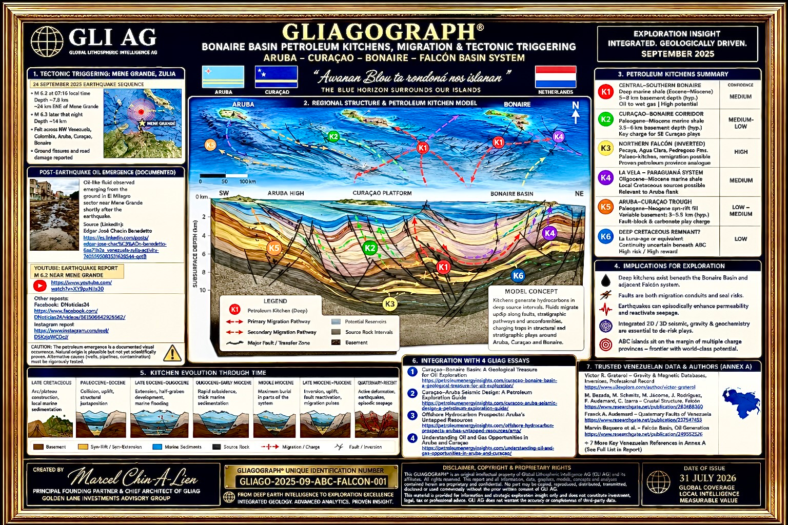
GLIAG’s working model identifies five inferred generative depocentres across the Falcón–Bonaire system. They are not equally weighted, and they should not be treated as equally speculative.
| KITCHEN | DEPOCENTRE | CHARACTER |
|---|---|---|
| K1 | Central Bonaire Basin — main depocentre | Deepest sediment fill, strong negative Bouguer trough. Highest-priority oil kitchen with a deep gas core. |
| K2 | Aruba–Paraguaná depocentre | Marginal, secondary oil kitchen; charge probable but unresolved. |
| K3 | Falcón onshore — La Vela / Urumaco | Proven kitchen: Cumarebo, La Vela, Mene de Mauroa. The direct calibration point for K1. |
| K4 | Gulf of Venezuela / Perla trend | Proven gas kitchen — the >16 Tcf Perla discovery bounds the western envelope. |
| K5 | Curaçao Ridge / Los Roques pockets | Speculative, structurally isolated, easternmost — retained for completeness, not dismissed. |
Traced through four palaeo-time slices — end-Eocene, end-Oligocene, mid-Miocene inversion onset, and Recent — the picture is one of a source system that matures from the margins inward: K3 enters the oil window first, K1 follows and eventually reaches a gas-generating core, and K4 delivers its Perla-scale charge on its own independent clock. Migration fairways develop along NW-striking normal faults, later filtered by mid-Miocene inversion, toward the southern flanks of Curaçao and Bonaire — precisely where GLIAG ranks its highest-priority prospective area, P1.
···
The kitchen is not the whole story
A static kitchen-to-trap picture is not sufficient for a plate boundary that moves. Generation may be continuous. Delivery is not.
The Caribbean–South American boundary beneath the ABC islands is one of the most active oblique strike-slip belts on Earth, distributing roughly 20 mm/year of right-lateral motion across the El Pilar, San Sebastián, Morón, Oca–Ancón and Boconó fault systems. That same NW-striking transverse fault family segments the Bonaire Basin itself. Large earthquakes on this boundary do not merely shake buildings — they redistribute pore pressure across fault networks, transiently opening sealed fractures, venting overpressured reservoirs through fault-valve behaviour, and driving aftershock fluid diffusion that continues for months. In the petroleum-system literature this is called seismic pumping: continuous buoyancy-driven flow, overlaid by tectonically pulsed permeability enhancement.
Mene Grande, September 2025
On 24–25 September 2025, a shallow doublet — M6.2 and M6.3, thirty minutes apart — ruptured the eastern-Maracaibo segment of the Boconó–Icotea fault system near Mene Grande, Zulia: the town whose name comes from the natural oil menes that supported centuries of hand-dug extraction, and near which Zumaque-1, Venezuela’s first commercial well, was drilled in 1914. Shaking was felt at intensity IV in Aruba, Curaçao and Bonaire — direct confirmation that a single rupture on the eastern-Maracaibo fault system loads the ABC crustal block mechanically, not just geographically.
In the months that followed, surface hydrocarbon expression along the Sur del Lago and eastern Maracaibo corridor was documented repeatedly and independently: new crude emergence along the Casigua El Cubo–El Carmelo road, continuing derrames in Bachaquero and San Francisco municipalities, and satellite-tracked releases totalling roughly 50,000 barrels across a 30-kilometre slick in 2026 alone. A subsequent M7.2/M7.5 doublet in Yaracuy in June 2026 reactivated the wider Boconó–San Sebastián corridor, with the geological consensus attributing that rupture to tectonic loading rather than induced seismicity.
Why this matters offshore. The E–W ridge on which Aruba, Curaçao and Bonaire sit is loaded by the same fault family that ruptured at Mene Grande. If the Falcón–Maracaibo petroleum system remains hydraulically active enough to produce fresh roadside seepage in 2025 and 2026, the working hypothesis for the offshore Bonaire Basin must assume the equivalent process — pulsed hydrocarbon flux updip along NW-striking faults toward the southern island flanks, not a steady Darcy-flow drip.
This has two consequences that a conventional kitchen map does not capture. First, migration-fairway maps for the Phase D reconstruction need a probabilistic pulsed-migration overlay, not only a steady-state one. Second, trap integrity becomes a paired risk rather than a one-sided upside: a structure that receives pulsed charge from K1 during a large event may equally leak if its seal is close to failure on the same fault. Any serious charge-risk assessment for the southern Curaçao and Bonaire flanks now has to model coseismic seal failure alongside coseismic charge delivery.
What this means for exploration priority
Ranked updip of the kitchen model, and consistent with GLIAG’s mosaic petroleum-system-architecture doctrine, five prospective areas emerge on the ABC island flanks:
- P1 — Southern Curaçao–Bonaire flank, updip of K1. Highest priority.
- P2 — Southwestern transition toward the K4 (Perla) trend.
- P3 — Aruba west flank, updip of K2.
- P4 — Northern Curaçao–Bonaire flank, dependent on long-distance migration.
- P5 — Curaçao Ridge / Los Roques pockets, speculative.
None of this is a licensing recommendation. The gravimetric compilations, kitchen depocentres and migration fairways described here are schematic working hypotheses, offered for scoping and academic dialogue, and they exist to be tested — not assumed — by the basement-depth grid, palaeo-reconstruction and pseudo-well maturation work that GLIAG has scoped for the basin. What the September 2025 Mene Grande sequence adds is not proof of an offshore discovery. It is proof that the delivery mechanism this basin depends on is demonstrably alive, on the same fault system, within the same crustal block, in the current decade.
The wider architecture
This basin sits inside GLIAG’s broader doctrine of productive sovereignty and Deep Time as a strategic frame — the same doctrine built for the Guyana–Suriname Basin, extended westward across the Leeward Antilles. It also strengthens the geological case, adjacent to SH-2050, for reading Curaçao and Aruba’s offshore potential as a strategic industrial complement to Suriname’s own petroleum-era transformation, not as an unrelated frontier story. Where information becomes intelligence, and where discoveries become strategy, a basin does not need to be famous to matter. It needs to have cooked, and it needs a fault system willing to deliver what it cooked. The Bonaire Basin appears to have both.
Drs. M.P.T. Chin-A-Lien, MBA, M.Sc., Ing. Geologist
Principal Founding Partner & Chief Architect, GLIAG (Golden Lane Investments Advisory Group)
Certified Professional Geologist Nr. 5201-1996 (AAPG) · Chartered European Geologist Nr. 92-1996 (EFG) · Energy Negotiator, June 2021 (AIEN)
Soso Lobi.
All interpretations, kitchen depocentres (K1–K5) and prospective-area rankings (P1–P5) in this essay are schematic working hypotheses prepared for scoping and dialogue, condensed from the GLIAG Terms of Reference for a gravimetric, basement-depth and petroleum-kitchen study of the Bonaire Basin (GLIAG-TOR-2026-BONAIRE-001). They are not to be used for licensing decisions, well planning, or reserve booking. © 2026 Marcel Chin-A-Lien and GLIAG. All rights reserved.