
By Marcel Chin-A-Lien, Petroleum & Energy Advisor – 6th feb 2026
Introduction
The Tambaredjo oil field, located in onshore Suriname, represents one of the most enduring and cost-efficient petroleum systems in the Guiana Basin.
Frequently characterized as a “simple” field, Tambaredjo is in reality a highly efficient stratigraphic system, combining shallow reservoirs, excellent sealing capacity, minimal drilling risk, and a sedimentary architecture that repeatedly delivers commercial hydrocarbons.
This article revisits Tambaredjo from an integrated geological perspective, combining stratigraphic framework, type-log interpretation, depositional environment analysis, drilling depth and cost metrics, and petroleum system implications.
The objective is not merely descriptive, but explanatory: to clarify why Tambaredjo works so consistently, and why it remains a benchmark for onshore petroleum development in northern South America.
Stratigraphic Framework and Depth Architecture
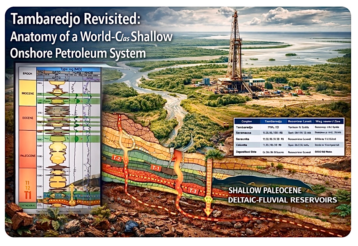
Tambaredjo is developed within a relatively thin Cenozoic sedimentary section. Total depth (TD) of the majority of production wells lies between 1,450 and 1,550 m measured depth, drilled from surface to just below the Paleocene reservoir interval.
The generalized stratigraphic framework is summarized as follows:
- Quaternary – Miocene (0–500 m): Coastal plain to deltaic sands and clays
- Oligocene – Eocene (500–1,100 m): Dominantly marine shales, regionally extensive
- Late Eocene – Early Paleocene (1,100–1,350 m): Transitional marine–continental floodplain deposits
- Paleocene T-interval (1,350–1,500 m): Fluvial–delta plain reservoirs (T3, T2, T1)
Wells typically terminate 10–50 m below the lowest T-sand, locally penetrating the uppermost Cretaceous to ensure full reservoir coverage and logging control.
The Paleocene T-Zands: Type Log Interpretation
The Paleocene T-zands form the primary producing interval of Tambaredjo. Type-log interpretation, adapted from the GeoAtlas van Suriname (Staatsolie), reveals a vertically stacked reservoir system composed of multiple sand–seal couplets.
Key log characteristics include:
- Low gamma-ray responses indicating clean to moderately clean sands
- Elevated resistivity associated with hydrocarbon saturation
- Consistent neutron–density responses reflecting good reservoir porosity
Individual sand bodies typically range from 5 to 15 m in thickness. Cumulatively, the Paleocene interval provides approximately 30–50 m of net oil-bearing reservoir, distributed across multiple stacked flow units.
Figure: Conceptual geological overview of the Tambaredjo petroleum system. The type log is adapted from the GeoAtlas van Suriname (Staatsolie). The illustration is intentionally schematic and not to scale, and may contain minor simplifications or illustrative inaccuracies. All stratigraphic, sedimentological, depth, and petroleum system interpretations discussed in this article are derived from verified geological data and are substantiated in the accompanying text.
Sedimentological Framework: Fluvial to Delta-Plain Systems
The log motifs and vertical stacking patterns are characteristic of a low-energy fluvial to delta-plain depositional system. Dominant sedimentary environments include meandering fluvial channels, crevasse splays, distributary channels, and extensive floodplain and back-swamp settings.
These environments generate laterally continuous sand bodies encased within fine-grained floodplain deposits. Porosities are commonly high for such shallow systems, typically in the 25–32% range, underpinning stable long-term productivity.
Seal Architecture and Vertical Compartmentalization
A defining feature of the Tambaredjo system is the repeated presence of highly effective local top seals.
Rather than relying on a single regional sealing horizon, each reservoir unit is overlain by floodplain clay, lacustrine shale, or lignite-rich back-swamp deposits.
These lithologies exhibit extremely low permeability and provide reliable vertical containment.
Lignite-bearing intervals, in particular, play a critical role in sealing and contribute to controlled compartmentalization, supporting long field life and flexible production strategies.
Drilling Time, Cost, and Development Efficiency
Tambaredjo is developed through a highly industrialized, repeatable drilling program.
Typical drilling and wireline logging operations require approximately 12 days per well, with spud-to-logs durations of two to three weeks when logistics are included.
Total development costs are exceptionally low by international standards. Onshore development wells typically cost on the order of hundreds of thousands of US dollars per well, providing exceptional economic resilience across commodity price cycles.
Petroleum System Implications
Tambaredjo represents a compact and internally consistent petroleum system, characterized by very long migration distances, all the way from the offshore ACT oil kitchens, trapping in late Teriary times, and rather efficient charge:
- Source: mainly ACT source rocks
- Reservoir: Fluvial–delta plain Paleocene sands
- Seal: Floodplain clays and lignite
- Trap: Predominantly stratigraphic, with minor structural influence, against and around the Bakhuys Horst.
Comparison with Other Onshore and Nearshore Fields
| Area | Typical TD | Reservoir Interval | Depositional Style |
|---|---|---|---|
| Tambaredjo | ~1.5 km | Paleocene T | Fluvial / delta plain |
| Saramacca | 1.6–1.8 km | Paleocene–Krijt | Channel-dominated fluvial |
| Calcutta | 1.7–2.0 km | Paleocene–Krijt | Fluvial–deltaic |
| Weg naar Zee | 2.0–2.3+ km | Paleocene | Delta front / shallow marine |
Conclusions
Tambaredjo demonstrates that world-class petroleum systems do not require great depth or complexity.
Its success derives from the disciplined interaction of sedimentology, stratigraphy, and operational execution, resulting in one of the most efficient onshore oil developments globally.
After developing Tambaredjo field from 1980 onwards, beginning with just 200 barrels per day, Staatsolie and IOC partners are now determined to discover, unveil and produce the vast offshore petroleum resources of the Suriname area of the Guyana Suriname Super Basin.
Beginning with Gran Morgu, Block 58, in 2028, with a plateau production of 220,000 barrels of high quality light oil per day.
Followed by Sloanea gas field in Block 52.
About the Author
Marcel Chin-A-Lien is a Petroleum & Energy Advisor with extensive experience in petroleum geology, basin analysis, and energy strategy.
He advises companies, institutions, and investors on upstream geology, exploration risk, petroleum investments and long-term energy positioning, with particular expertise in Suriname and the Guiana Basin.

