
Written by Marcel Chin-A-Lien – Petroleum & Energy Advisor – Golden Lane Investments Advisory Group.
Where a 550-million-year-old subsurface salt giant meets 20% of global petroleum transport
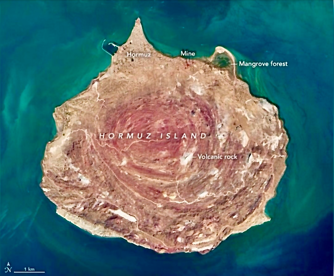
Credit: Picture from NASA Landsat / Earth Observatory — Public Domain · Strait of Hormuz, Persian Gulf
In the narrow Strait of Hormuz, a ribbon of water barely 56 km wide at its pinch point, roughly 20 million barrels of oil and petroleum liquids flow every single day, approximately 20% of all petroleum liquids consumed on Earth (EIA 2024–2025 data).
This single maritime artery carries the lifeblood of the global economy from the Persian Gulf to the Indian Ocean and beyond.
Right in the middle of this critical shipping lane sits a geological celebrity: Hormuz Island, Iran’s “Rainbow Island.”
Its swirling reds, yellows, oranges and whites are not paint or post-processing.
They are the exposed heart of a massive salt diapir that has risen from deep beneath the seafloor.
This is no surface curiosity.
It is a direct window into the subsurface forces that created the world’s most important oil transit route.
20M BARRELS/DAY THROUGH THE STRAIT
20% OF GLOBAL PETROLEUM LIQUIDS
56 km MINIMUM STRAIT WIDTH
550 Ma AGE OF HORMUZ SALT FORMATION
The Subsurface Story: Birth of the Hormuz Salt Layer
More than 550 million years ago, during the Late Ediacaran to Early Cambrian, the Arabian Plate hosted restricted, hypersaline basins along the edge of the ancient supercontinent.
Thick sequences of halite (rock salt), gypsum, anhydrite, dolomite and interbedded volcanic rocks — rhyolites and basalts — were deposited over millennia.
Together these constitute the famous Hormuz Salt Formation.
Buried today under 5–10 km of younger limestone, shale and sandstone, this evaporite layer is less dense than the rocks pressing down upon it. Under heat and pressure it behaves like a viscous fluid. When tectonic stress or differential sediment loading disturbs the equilibrium, the salt begins to flow upward — a process geologists call halokinesis.
KEY SUBSURFACE FACTThe Hormuz salt acts as a regional décollement (detachment) surface across the Zagros Fold-and-Thrust Belt. It allows the overlying sedimentary cover to slide and fold independently of the basement during plate collision — exactly the mechanism that formed the giant anticlinal oil traps of Saudi Arabia, Iran, Kuwait and the UAE.
The Diapir Rises: From Kilometres Deep to a Surface Rainbow
Beginning in the Paleozoic and accelerating dramatically during the Miocene–Recent Zagros orogeny — the ongoing collision between the Arabian and Eurasian plates — the buoyant salt punched upward through the overburden along zones of structural weakness. The result on Hormuz Island is a textbook emergent salt diapir:
- Concentric folding of evaporite layers visible from orbit
- “Salt glaciers” (namakiers) that once flowed outward like slow lava across the surface
- Exotic blocks of volcanic rock and iron-oxide-stained sediments carried upward from depth
- Ongoing slow uplift — parts of the island continue rising at millimetres per year

The vivid colours are a direct read-out of the diapir’s mineralogy: deep reds and rusty browns from haematite and iron oxides; ochre and orange from goethite; white and pale grey from halite and gypsum; olive and charcoal from volcanic rocks injected into the rising salt mass at depth long before it reached the surface.
“Every colour stripe on this island is a chapter of Earth history rising from kilometres underground into daylight.”
Bathymetry: How the Diapir Shapes the Seafloor and Shipping Lanes
The Persian Gulf is one of the shallowest semi-enclosed seas on the planet — average depth 35–50 m. The Strait of Hormuz provides the only deep exit, with water depths typically 60–120 m across the main channel and locally exceeding 200 m along the Omani (southern) side.
Hormuz Island and its neighbouring salt domes create local bathymetric highs and shallows that are not incidental to geography: they actively sculpt the navigable corridor. Laden supertankers drawing up to 25 m must carefully thread the deeper southern trough to avoid the Iranian coastal shallows and the island chain itself. The diapirs have literally carved the choke point we depend upon today — a narrow, structurally controlled gateway whose morphology is the direct surface expression of deep salt tectonics operating over hundreds of millions of years.

Ancient Salt Controls Modern Energy Security
The same Zagros collision zone that squeezed the Hormuz salt upward also folded the overlying strata into giant anticlines — the structural traps that hold tens of billions of barrels of crude oil and trillions of cubic feet of natural gas beneath the Gulf floor and onshore Iran, Saudi Arabia, Kuwait and the UAE.
The salt itself frequently serves as an excellent seal, plastic enough to flow around porous reservoir rocks and prevent hydrocarbons from migrating to the surface and being lost. Without the Hormuz evaporites, many of the region’s supergiant fields — Ghawar, Burgan, South Pars/North Dome — would never have formed or been preserved in their current configuration.
And without the resulting narrow strait created by the tectonic syntaxis and the diapiric islands constraining deep navigation, those same fields would not be forced through a single 56-km-wide maritime bottleneck upon which the price of energy, the balance of trade and the security calculations of every major power currently hinge.
THE ONE-LINE SUMMARYA 550-million-year-old layer of salt deposited in ancient evaporite basins now dictates where 20% of the world’s daily oil supply must sail — and its own colourful heart stands exposed as an island at the very centre of that passage.
A Living Laboratory at the Centre of the World
Hormuz Island is far more than a tourist destination of rainbow mountains and red-sand beaches. It is a three-dimensional, subsurface-to-surface demonstration of how deep Earth processes — evaporite deposition, salt mobility, plate collision and long-range halokinesis — converge to create the physical geography that underpins modern global energy flows.
Every supertanker that passes within sight of its polychromatic cliffs is navigating a seaway literally shaped by the same geological forces that generated the oil in its holds. The rainbow and the barrel are products of the same ancient story, still being written one millimetre of uplift at a time.

Scientific Feature — Hormuz Island: Earth Sciences & Energy Geography
Grounded in peer-reviewed salt-tectonics literature: Hormuz Series stratigraphy, Zagros halokinesis studies, and regional Gulf bathymetry research.
EIA throughput figures: U.S. Energy Information Administration, World Oil Transit Chokepoints 2024–2025 update.
Images: NASA Earth Observatory (public domain) · Columbia University Gulf2000 Project · Wikimedia Commons (CC BY-SA 4.0)