GLIAG · GOLDEN LANE INVESTMENTS ADVISORY GROUP
GLIAG STRATEGIC PETROLEUM INTELLIGENCE PLATFORM
Critical Raw Materials for Suriname
Onshore Endowment, Offshore Frontier, and the Deep-Sea Question
A GLIAG Position Essay — Critical & Transition-Enabling Minerals, Onshore and Offshore
| Author | Marcel Chin-A-Lien — Global Petroleum & Energy Advisor, Founding Partner, GLIAG |
| Publication | Petroleum & Energy Insights |
| Date | 3 August 2026 |
| Document ID | GLIAG_CRM_2026_01_Rev01 |
“Onshore first, offshore-margin second, deep-sea last.”
Where Information Becomes Intelligence. · From Geology to Sovereignty.
Contents
• Executive Summary
• Part 1 — Onshore Suriname: which CRMs, which formations, which geography
• Part 2 — Offshore and deep-sea: where, why, how
• Part 3 — Worldwide “success anchors” and their honest verdicts
• Part 4 — GLIAG position and next steps
• Companion GLIAG Essay: Clickable Cross-References
• Full Reference Set
• Legal Notice · Disclaimer · Copyright · IP
Executive Summary
Figure 1 — Global CRM demand vs. production, 2022–2050. GLIAG redraw after UNCTAD (2022) and IEA data, as presented at the National Development Summit Suriname — Duurzaam Suriname 3.0.
The Duurzaam Suriname 3.0 framing is the correct strategic lens for Suriname’s decade. Global demand for lithium, nickel, cobalt and copper diverges structurally from production out to 2050. This is not merely a cyclical commodity story; it is a geopolitical materials story. Suriname occupies three consequential mineral provinces at once: the Paleoproterozoic Guiana Shield onshore, the Guyana–Suriname petroleum margin offshore, and — through its Extended Continental Shelf claim under UNCLOS Article 76 — potential access to the deep Atlantic seabed.
This essay does three things:
1. Onshore. Maps where CRMs are — and are likely to be — available in Suriname, by formation and geography, building on GLIAG’s mantle-melting framework.
2. Offshore & deep-sea. Sets out where, why and how Suriname could — or should not — engage with deep-sea mining, including the CCZ, Cook Islands EEZ, Norwegian Continental Shelf and Japan’s cobalt-rich crust programme.
3. Anchors. Grounds the policy conversation in worldwide projects, regulatory developments, successes and failures.
| GLIAG position: Onshore first, offshore-margin second — in tandem with oil and gas — deep-sea last, and only under conditions made defensible by a completed international regulatory framework. |
Part 1 — Onshore Suriname: which CRMs, which formations, which geography
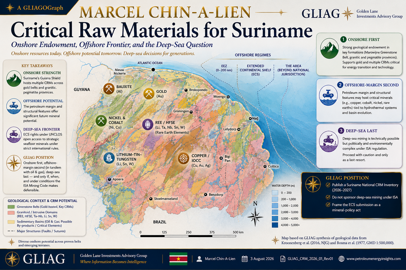
Figure 2 — GLIAG schematic geological and critical-raw-materials map of Suriname, after Kroonenberg et al. (2016) and Bosma et al. (1977). The map is schematic and intended for orientation and investor communication, not tenure or navigation.
1.1 The geological substrate
Suriname’s onshore is approximately 90% Precambrian Guiana Shield, with the remaining area formed by the Cenozoic coastal plain. The shield can be read, from oldest to youngest, as a sequence of mineral-system opportunities:
• Archean and early Paleoproterozoic basement — high-grade gneisses and granitoids.
• Marowijne Greenstone Belt (Paramaka, Armina and Rosebel formations) — the gold engine of Suriname and part of the Trans-Amazonian belt shared with Guyana and French Guiana.
• Post-orogenic granitoids and pegmatite provinces — natural hosts for REE, HFSE, Ta–Nb, Li, Sn and W.
• Mafic–alkaline intrusions and CAMP basalts (~201 Ma) — structural corridors linked by GLIAG to Ni–Cu–Co sulphide and Fe–oxide–Cu–U–Au–REE (IOCG) systems.
• Coastal-plain lateritic cover (Tertiary–Quaternary) — the bauxite engine.
1.2 CRM-by-CRM inventory — formation and geography
| # | Mineral / commodity | Host formation / rock suite | Geography | Status / GLIAG interpretation |
| 1 | Bauxite (Al) | Lateritic profiles on Tertiary sediments and Proterozoic bedrock | Moengo; Onverdacht–Lelydorp–Paranam; Bakhuis, Nassau and Brownsberg mountains | Historical production; large interior resources remain undeveloped after the Suralco exit. |
| 2 | Gold (Au) | Paramaka / Armina greenstones; Rosebel Formation clastics and quartz veins | Rosebel, Merian, Saramacca, Sarafina, Nassau, Lely and Sella Creek–Benzdorp | Two large mines active; several exploration plays; continuing fiscal anchor. |
| 3 | Nickel & Cobalt (Ni–Co) | Lateritic Ni over ultramafics; magmatic Ni–Cu–Co sulphides in mafic–alkaline suites and CAMP corridors | Bakhuis; Nassau–Brownsberg ultramafic bodies; CAMP dyke swarms | Under-explored; GLIAG identifies this as the highest-value under-explored frontier onshore. |
| 4 | REE + HFSE (Nb–Ta–Zr–Hf) | Post-orogenic peraluminous and alkaline granitoids; candidate carbonatites; pegmatites | Interior Sipaliwini and Brokopondo enriched-granitoid provinces | No systematic national REE campaign — the largest single inventory gap. |
| 5 | Lithium, Tin, Tungsten | LCT- and NYF-type pegmatites; Sn–W in evolved granites | Post-orogenic corridors in Sipaliwini and upper Marowijne | Speculative but geologically testable; requires dedicated pegmatite mapping. |
| 6 | Copper — IOCG systems | Fe–oxide–Cu–U–Au–REE deposits along CAMP-related structures | Interior transects linked to mafic–alkaline events | Frontier; Olympic Dam analogue is aspirational but geologically defensible as a test concept. |
| 7 | Kaolin, silica sand and industrial minerals | Coplanamalapan, Zanderij and Coesewijne formations | Coastal belt: Para, Wanica and Nickerie | Locally produced; potential for solar-glass silica if quality is proven. |
| 8 | Diamonds — mantle indicator | Kimberlitic affinities within CAMP-adjacent structures | Interior | Scientific indicator of deep-mantle input, not currently a commercial mining play. |
1.3 How to read the CRM map
• Coastal-plain bauxite corridor — Moengo, Onverdacht–Paranam and Lelydorp.
• Marowijne Greenstone Belt — Rosebel/Saramacca, Merian, Lely, Nassau and the Sella Creek–Benzdorp artisanal gold districts.
• Bakhuis Granulite Belt — a multi-commodity Al–Ni–Cu–REE frontier.
• Central granitoid–felsic volcanic terrain — REE, HFSE, Ta–Nb and Li–Sn–W pegmatite targets.
• Coeroeni Gneiss Belt — Ni–Cu–PGE frontier along ultramafic–gabbroic bodies.
• CAMP dyke swarms — potential IOCG corridors.
• Offshore — Blocks 52/58 hydrocarbon geodata as a dual-use screening base; the ECS beyond 200 nm as a potential cobalt-rich-crust / polymetallic-nodule target.
1.4 What follows from the onshore picture
4. Suriname is not merely a bauxite-and-gold country. The same Paleoproterozoic-to-Mesozoic architecture that generated known mineral systems should also be tested for REE, Ni–Co, IOCG-type copper and pegmatite Li–Sn–W systems.
5. The Bakhuis–Nassau–Brownsberg corridor is the single most valuable under-explored district because Al, Ni, Co, Cu and REE may co-occur in the same geodynamic province.
6. A modern national CRM inventory has not been completed since the 1980s bulletin era. Airborne magnetic, radiometric and hyperspectral acquisition is the fastest route to a bankable inventory.
Part 2 — Offshore and deep-sea: where, why, how
2.1 Three offshore regimes — do not confuse them
Suriname’s offshore is not one legal or geological domain. It is three distinct regimes, each with its own prospectivity and regulator:
| Regime | Legal basis | What is — and is not — there | Regulator |
| A. Territorial sea + EEZ (0–200 nm) | UNCLOS Part V; Suriname Mining Decree 1986 | Placer heavy-mineral sands, offshore aggregate and possible shelf-edge phosphorite; oil and gas remain the dominant resource. | Ministry of Natural Resources; Staatsolie |
| B. Extended Continental Shelf beyond 200 nm | UNCLOS Article 76; CLCS submission | Potential cobalt-rich ferromanganese crusts on seamounts, possible polymetallic sulphides on volcanic edifices and sedimentary phosphorite. | Coastal State, once outer limits are confirmed |
| C. “The Area” beyond national jurisdiction | UNCLOS Part XI; ISA Mining Code | Polymetallic nodules, cobalt-rich crusts and seafloor massive sulphides on abyssal plains and mid-ocean ridges. | International Seabed Authority |
Key regulatory fact: The source document records that commercial deep-sea mining had not been authorised and that the ISA exploitation regulations remained under negotiation. This regulatory gate is central to GLIAG’s sequencing recommendation.
2.2 The three deep-sea mineral types — what and why
• Polymetallic nodules (PMN) — Potato-sized concretions of Mn–Ni–Cu–Co, with trace REE, at approximately 4,000–6,000 m depth on abyssal plains. Key provinces include the Clarion–Clipperton Zone and Cook Islands EEZ.
• Cobalt-rich ferromanganese crusts (CFC) — Millimetre-to-centimetre coatings on seamount flanks at roughly 800–2,500 m depth. Japan’s programme near Minami-Tori-shima is the technology anchor.
• Seafloor massive sulphides (SMS) — Cu–Zn–Au–Ag mineralisation at active or extinct hydrothermal vents. Solwara 1 in Papua New Guinea is the principal cautionary failure.
2.3 Where the money and the risk actually are — country case files
Clarion–Clipperton Zone / TMC
Published project economics indicate major theoretical value, but governance remains unresolved. The geology is real; the authorisation pathway is contested.
Cook Islands EEZ
A national-jurisdiction model with exploration licences, yet exploitation has been deferred to at least 2032. Even a willing State treats the sector as pre-commercial.
Norway
The closest OECD petro-state analogue. Despite offshore engineering maturity, seabed-mineral ambitions were paused. Political and environmental risk exceeded geological enthusiasm.
Japan
The technology anchor. JOGMEC’s cobalt-crust excavation test remains the strongest operational proof-of-concept.
New Zealand — Chatham Rise phosphate
A defined, relatively shallow resource with a permit still failed to cross the environmental permitting bar.
Papua New Guinea — Nautilus / Solwara 1
The anchor failure. Public balance-sheet exposure and project insolvency demonstrate why sovereign sponsorship must be treated as liability, not prestige.
2.4 What this means for Suriname’s Extended Continental Shelf
7. Treat the ECS submission as a mineral-policy act, not only a boundary act. Confirmed outer continental shelf is national mineral jurisdiction outside the ISA regime.
8. Piggy-back mineral prospectivity mapping on hydrocarbon geodata. Multibeam bathymetry, gravity and multichannel seismic can image seamount and abyssal-plain morphology at shared cost.
Part 3 — Worldwide “success anchors” and their honest verdicts
| # | Project / country | Resource | Status in source document | Verdict for Suriname |
| 1 | TMC / NORI-D, CCZ | Polymetallic nodules | Large published NPV; exploration contract; no commercial mining | Geology anchor; governance warning |
| 2 | Cook Islands EEZ | Polymetallic nodules | Three exploration licences; exploitation deferred to ≥2032 | National-jurisdiction model; pre-commercial |
| 3 | Norwegian Continental Shelf | SMS + CFC | Large area opened; programme paused | OECD parallel; even Norway stopped short |
| 4 | JOGMEC, Minami-Tori-shima | Cobalt-rich crusts | Successful excavation test; commercial ambition before 2030 | Technology anchor |
| 5 | Chatham Rock Phosphate | Phosphorite nodules | Permit held; environmental approval rejected | Permitting warning |
| 6 | Nautilus / Solwara 1 | Seafloor massive sulphides | Insolvent; major public loss | Do-not-repeat anchor |
| 7 | ISA Mining Code | Regulatory framework | Exploration contracts exist; exploitation regulations incomplete | The gating item |
Onshore anchors that Suriname should study explicitly
• Olympic Dam, South Australia — reference IOCG system for testing CAMP corridors.
• Mount Weld, Western Australia — carbonatite-hosted REE model for a Guiana Shield campaign.
• Greenbushes, Western Australia — LCT pegmatite lithium model for interior mapping.
• Sudbury and Voisey’s Bay, Canada — magmatic Ni–Cu–Co analogues for the Bakhuis–Nassau corridor.
Part 4 — GLIAG position and next steps
9. Publish a Suriname National CRM Inventory (2026–2027). Airborne magnetic, radiometric and hyperspectral acquisition, integrated with existing geological and offshore datasets. Deliverable: a 12-CRM prospectivity atlas at 1:250,000.
10. Do not sponsor deep-sea mining under ISA. Sponsorship is a sovereign liability. Permit knowledge-building and exploration where defensible; defer exploitation until the Mining Code and environmental safeguards are complete.
11. Frame the ECS submission as a mineral-policy act. Every confirmed square kilometre has potential strategic mineral significance; hydrocarbon data should be reprocessed for mineral prospectivity.
12. Embed CRMs in Suriname Horizon 2050 & Beyond. Critical minerals are not an isolated mining policy. They belong inside the same integrated geology-to-industry, energy, infrastructure and sovereign-development architecture.
13. Anchor investor communication in the GLIAG mantle-melting essay. The companion paper provides the scientific spine for CRM prospectivity, target generation and investor communication.
Companion GLIAG Essay — Clickable Cross-References
For readers entering through this essay, the companion GLIAG paper can be opened directly at the following sections:
• Unified Mantle-Melting and Volatile-Rich Melt Channels
• Geological Expression in the Guiana Shield / Guyana Craton
• “Proofs” from Rock Record and Mineral Systems
• Implications for Critical and Transition-Enabling Minerals
• Strategic Perspective for Suriname and Guyana
• References & About the Author
Full Reference Set — Clickable
Legal Notice · Disclaimer · Copyright · Intellectual Property
GLIAG — Golden Lane Investments Advisory Group. Petroleum · Energy · Critical Minerals · Strategic Intelligence · Project Management Consulting. This position essay is prepared for professional discussion and website publication. It does not constitute investment, legal, technical, environmental or regulatory advice, nor a mineral-resource estimate or survey-grade geological product. Independent verification, competent-person review and applicable governmental approvals remain essential before any investment or policy decision.
Copyright and intellectual property. © 2026 M. Chin-A-Lien / GLIAG. All rights reserved. The GLIAG analytical framing, interpretations, strategic sequencing, maps, graphics, tables, synthesis and recommendations are proprietary intellectual work. No reproduction, adaptation, extraction, commercial reuse or redistribution is permitted without prior written consent, except for brief quotation with full attribution and a direct hyperlink to the original publication.
GLIAG_CRM_2026_01_Rev01 · petroleumenergyinsights.com · © 2026 M. Chin-A-Lien / GLIAG
Copyright, Intellectual Property and Proprietary Rights
© 2026 GLIAG N.V. — Golden Lane Investments Advisory Group. All rights reserved.
This publication, including its analysis, structure, terminology, strategic interpretations, methodologies, classifications, tables, diagrams, maps, recommendations and conclusions, is the copyrighted and proprietary intellectual work of GLIAG N.V. and Marcel P.T. Chin-A-Lien, except where third-party material is expressly identified and attributed.
No part may be reproduced, translated, adapted, republished, redistributed, commercially used, incorporated into another report or proposal, entered into an artificial-intelligence or machine-learning system, or used to create derivative methodologies or advisory products without prior written authorization from GLIAG N.V.
Publication or disclosure does not transfer ownership, grant any licence, or waive GLIAG’s rights in its underlying know-how, unpublished research, models, data, calculations, strategies and methodologies. Brief quotation is permitted only where legally allowed and with full and prominent attribution.
Unauthorised use, misappropriation, removal of attribution or commercial exploitation may result in legal action and all available remedies. All rights not expressly granted in writing are strictly reserved.