
Walking the Rocks of Faith: A Geological Pilgrimage Along the Camino Francés
Written by Marcel Chin-A-Lien – Petroleum Geoscientist & Energy Insights Advisor – 28th June 2025.
” Buen Camino “.
Ever walked this geological and spiritual famous and now most popular and iconic pilgrim’s route?
Enjoy.
From the Cretaceous flysch of the Pyrenees to the ancient granite of Santiago, the Camino Francés is more than a spiritual journey.
It is a 772 km-long geological transect across Spain’s most diverse tectonic provinces.
The Camino de Santiago’s French Route, spanning over 770 kilometers from Saint-Jean-Pied-de-Port to Santiago de Compostela, is often walked as a physical and spiritual journey.
But beneath its cobbled roads and Roman bridges lies a deeper narrative: a vivid geological odyssey through some of Iberia’s most ancient and dynamic terranes.
This essay takes the reader on a pilgrim’s geological journey, westward across time and tectonics.

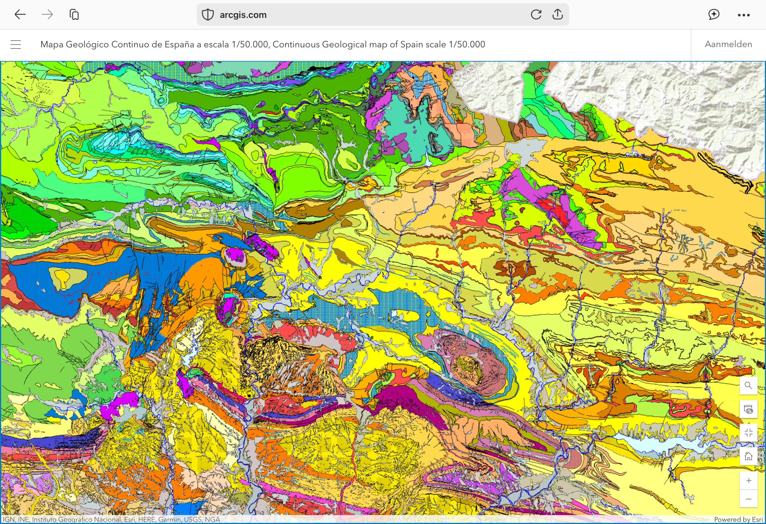
The main featured map is the Geological map, of Pamplona and surroundings, taken from ArcGis.
1. Pyrenean Beginnings: Flysch and Folded Basins
The Camino begins in the Cretaceous flysch of the western Pyrenees.
These deep-marine sediments, laid down in rhythmic turbidite sequences, were folded and thrusted during the collision between the Iberian and Eurasian plates ~50 million years ago.
Roncesvalles, perched at nearly 950 m elevation, sits amid this heavily deformed zone.
These flysch units are composed of alternating sandstones and marls, part of an accretionary prism that grew during subduction.
2. Ebro Basin: Tertiary Tranquility in Pamplona and Logroño
Descending into the Ebro foreland basin, the route enters a world of Tertiary continental sediments.
Pamplona, Logroño, and Estella are built on fluvial and lacustrine sandstones and marls deposited in the basin that formed as the Pyrenees uplifted. This quiet sedimentary regime represents a shift from tectonic violence to post-orogenic sedimentation. Here, redbeds, gypsum layers, and conglomerates gently blanket older structures.
3. The Castilian Meseta: Jurassic to Cretaceous Platform Limestones
From Burgos to Carrión de los Condes, pilgrims traverse the Castilian Plateau, a vast erosional surface developed on Jurassic and Lower Cretaceous limestones.
These carbonate rocks once formed part of a warm, shallow Tethyan shelf. Now, they host karst systems, dolines, and aquifers.
Their relative flatness belies the gentle warping and doming that occurred during the Alpine orogeny.
4. León and the Asturian Massif: Tertiary Intramontane Basins
Approaching León, the walker enters a Tertiary intramontane basin, bounded by the uplifted Cantabrian and Asturian ranges.
The geology here is dominated by Miocene clastics, fluvial gravels, silts, and muds—derived from surrounding Paleozoic highlands.
These deposits mark the late stages of mountain erosion, gradually filling the basins formed during Alpine tectonics.
5. Foncebadón to O Cebreiro: Paleozoic Highlands and Ancient Metamorphism
The climb toward Foncebadón and later O Cebreiro takes the pilgrim over some of Iberia’s oldest rocks: Paleozoic quartzites, slates, and schists.
These rocks, deformed and metamorphosed during the Variscan (Hercynian) orogeny (~300 Ma), form the Cantabrian and Galician massifs.
They are often rich in iron and have been historically mined.
Here, walkers cross regional thrusts and recumbent folds, a record of the continent’s ancient collisions.
6. Into Galicia: The Granitic Basement and Final Descent
As the trail winds westward into Galicia, the landscape becomes greener and wetter.
The rocks shift to granitic basement complexes, intruded during the late stages of the Variscan orogeny.
Around Santiago de Compostela, walkers tread atop peraluminous biotite granites and granodiorites.
These resilient plutonic bodies underlie the lush topography and have given rise to the region’s mineral-rich soils.
Geological Cross-Section: From Cretaceous Flysch to Galician Granite

This cross-section illustrates the elevation profile and underlying geology from east to west. Each province—Pyrenees, Ebro Basin, Meseta, Cantabrian Ranges, and Galician Massif—is represented along this spiritual and geological journey.

Explanation of the main geological map of the area around Pamplona:
Geological History and Tectonics of Pamplona, Spain
The Geological Story of Pamplona, Spain: A Landscape Written in Stone

Introduction
The region surrounding Pamplona, Spain, is a tapestry of color on the geological map, each hue representing a unique chapter in the Earth’s history. This landscape, nestled between the Pyrenees and the Ebro Basin, is a living record of ancient seas, mountain building, and the relentless power of tectonic forces. Let us explore how these geologic and geomorphological wonders came to be.
1. The Foundations: Ancient Rocks and Early Seas
The oldest rocks in the area, seen as deep greens and blues in the north and west of the map, are remnants of the Paleozoic Era. These rocks—slates, schists, and limestones—were forged over 300 million years ago during the Variscan orogeny, when ancient continents collided to build the first great mountains of the region. Over time, these mountains eroded, and the land was submerged beneath warm, shallow seas.
2. Mesozoic Calm: Seas, Sediments, and Subtle Shifts
During the Mesozoic Era (252–66 million years ago), much of the region was covered by marine waters. The map’s lighter blues, purples, and pale greens represent thick layers of limestone, marl, and sandstone—sediments deposited in these ancient seas. Subtle tectonic stretching created basins and gentle folds, setting the stage for future drama.
3. The Pyrenean Revolution: Collision and Uplift
The most dramatic chapter began in the Cenozoic Era, about 65 million years ago, when the Iberian Peninsula collided with the Eurasian Plate. This titanic event, known as the Alpine orogeny, gave birth to the Pyrenees. The collision crumpled and thrust the older rocks skyward, forming mountain ranges and deep folds—seen on the map as tightly packed, curving bands of color.
- Thrust faults and folds (narrow, elongated features) mark the compressional forces at work.
- Strike-slip faults allowed blocks of crust to slide past each other, further complicating the structure.
4. The Ebro Basin: A Land of Sediment
As the Pyrenees rose, they shed vast quantities of sediment southward, filling the Ebro Basin (yellows and browns on the map). Here, rivers and lakes deposited layers of conglomerate, sandstone, and marl, gradually burying older rocks beneath a thick blanket of younger material.
5. Modern Landscape: Erosion and Exposure
Today, rivers cut through these layers, exposing the ancient rocks and creating the dramatic relief seen around Pamplona. The interplay of hard and soft rocks, combined with ongoing uplift and erosion, has sculpted valleys, ridges, and isolated hills—each telling a story of time, pressure, and change.
6. Key Geological Features on the Map
- Pyrenean Mountains (north): Steep, folded, and faulted Paleozoic and Mesozoic rocks.
- Ebro Basin (south and center): Broad valleys filled with Cenozoic sediments.
- Structural highs and lows: Anticlines, synclines, and fault-bounded blocks.
- River valleys: Blue lines tracing the erosive power of water through rock.
Conclusion
The geology of Pamplona is a vivid record of Earth’s restless energy. From ancient mountain roots to young river valleys, each layer and fold is a page in a story spanning hundreds of millions of years. The region’s complex geology is not just a scientific curiosity—it shapes the soils, the scenery, and even the culture of this remarkable corner of Spain.
Reflections
To walk the Camino Francés is to traverse not only a cultural landscape but a geological tapestry spanning hundreds of millions of years.
Each step westward, from deep marine Cretaceous flysch to the crystalline heart of Galicia, is also a step through Earth history.
For geologists, this pilgrimage offers a rare opportunity: to read the rocks beneath the feet, even as the soul seeks something higher.
Appendix: Philosophical Reflection
“The geologist on pilgrimage learns that faith and reason are not separate paths, but parallel ridges on the same mountain—weathered by time, shaped by pressure, and occasionally, illuminated by a sunrise.”
About the Author
Marcel Chin-A-Lien is a petroleum geologist and energy strategist with 48 years of global experience across the Americas, Africa, Southeast Asia, and the Middle East. He specializes in frontier basin exploration, energy policy advisory, and economic modeling for oil and gas developments. Marcel bridges geological insight with executive strategy—helping align subsurface reality with boardroom decisions. He is a lifelong explorer of both geological terrains and philosophical questions, fluent in the language of rock and reason alike.
📧 marcelchinalien@gmail.com