GLIAG · STRATEGIC PETROLEUM INTELLIGENCE
GLIAG · STRATEGIC PETROLEUM INTELLIGENCE ESSAY
PETROLEUM PROSPECTIVITY OF ARUBA
From Exposed Caribbean Plateau Basement to an Unproven Offshore Oligocene–Miocene Petroleum Fairway
A plate-tectonic, stratigraphic and petroleum-systems comparison with Curaçao, the Falcón–La Vela Basin and the Perla giant gas field
By Drs. Marcel P. T. Chin-A-Lien, MBA, M.Sc., Ing., CPG (AAPG), EurGeol (EFG)
Principal Founding Partner & Chief Architect
GLIAG N.V. — Golden Lane Investments Advisory Group
Publication ID: GLIAG-ARUBA-2026-001 · 29 July 2026 · Delft, The Netherlands
| EXECUTIVE VERDICTAruba is not presently a proven petroleum province. Its onshore geology is dominated by exposed Late Cretaceous Caribbean plateau–arc basement and a thin, discontinuous Cenozoic cover, so it cannot be treated as a direct outcrop analogue of the productive Falcón Basin or the Perla reservoir. The defensible exploration case lies offshore: buried fault-bounded depocentres on the Aruba flank may preserve Paleogene–Neogene source, reservoir and seal intervals removed by uplift or never deposited on the island. The strongest play concepts are Oligocene–Lower Miocene carbonate banks on structural highs, coeval syn-rift siliciclastics, and younger Miocene clastic reservoirs. The largest uncertainty is not reservoir presence but effective source-rock presence, maturity, charge access and trap timing. |
1. Scope, Method and Evidentiary Standard
This study is a frontier petroleum-systems screening, not a reserves opinion. It integrates the supplied geological map of the Paraguaná Peninsula, the Geological Survey of the Netherlands map of Aruba, published island geology, Caribbean plate reconstructions, Falcón Basin stratigraphy, field and well analogues, and Perla reservoir studies. Correlations are ranked as: (1) direct age–facies analogue, (2) depositional-system analogue, (3) tectonostratigraphic proxy, or (4) weak/non-transferable analogy.
Source: TNO Geological Map of the Kingdom of the Netherlands — Official overview map; Aruba, Curaçao and Bonaire are shown using harmonised island stratigraphy.
Source: Beets, Metten & Hoogendoorn (1996), Geological Map of Aruba — Foundational detailed mapping referenced by TNO and subsequent tectonic studies.
Source: User-supplied geological map of the Paraguaná Peninsula — Regional surface-geology framework used as a visual comparator; exact original cartographic provenance should be independently verified.
2. Geological Maps: What They Show—and What They Do Not
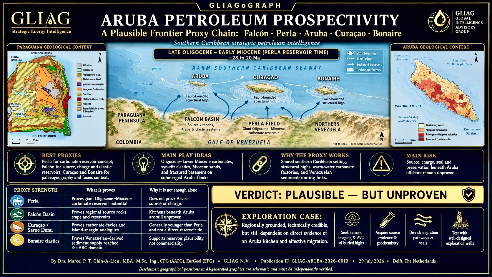
Figure 1. Geological map of the Paraguaná Peninsula supplied for this study. It emphasises Neogene carbonate abrasion surfaces, coastal deposits, faults and isolated older basement windows.
Figure 2. Simplified geological map of Aruba. The island is dominated by exposed Late Cretaceous Caribbean plateau–arc basement, including the Aruba Lava Formation, granitoid batholith and intrusive complexes, with younger Neogene–Quaternary carbonates and coastal deposits concentrated mainly along the margins. This GLIAG redrawing is an interpretive summary, not a substitute for the original RGD 1:50,000 map or TNO-GDN GIS data.
Sources: RGD/Beets, Metten & Hoogendoorn (1996), Geological Map of Aruba · TNO-GDN Geological Map of the Kingdom of the Netherlands
Figures 1 and 2 are regionally related but are not stratigraphically interchangeable. Paraguaná exposes a Cenozoic sedimentary and geomorphic archive on the South American margin, whereas Aruba primarily exposes uplifted Cretaceous plateau–arc basement. Figure 3 therefore does not project the modern surface geology of Paraguaná directly beneath Aruba; it tests whether buried offshore fault blocks could have preserved Cenozoic depocentres and carbonate factories that are absent, eroded or only thinly represented onshore.
3. Common Geological History: Late Cretaceous to Present
| Time | Regional process | ABC-island expression | Petroleum consequence |
| ~95–85 Ma | Caribbean large igneous province / oceanic plateau and arc modification | Aruba Lava Formation and intrusive complex; related but not identical basement histories on Curaçao. | Provides structural basement highs and fractured igneous objectives, but generally poor matrix reservoir and no indigenous source. |
| Late Cretaceous–Paleocene | Arc collision, uplift, erosion and local sedimentation | Subaerial erosion and divergent island stratigraphies; Curaçao preserves a better Cretaceous–Danian sedimentary record. | Creates unconformities, relief and possible weathered/fractured basement reservoirs. |
| Eocene | Oblique collision/accretion along northern South America; ABC islands in close palaeogeographic proximity | Aruba, Curaçao and Bonaire occupied neighbouring fault blocks along the plate boundary, but experienced different subsidence histories. | Potential local depocentres and Eocene clastics; correlation must be block-specific. |
| Late Eocene–Early Miocene | Tectonic collapse, transtension/back-arc or pull-apart subsidence in Falcón–La Vela domain | Major syn-rift accommodation; Oligocene siliciclastics and Early Miocene carbonate platforms developed on fault-block highs. | Principal analogue window for Aruba offshore carbonate and clastic plays. |
| Middle Miocene | Basin inversion and transpression | Falcón structures inverted; carbonate platforms drowned/buried; migration and trap formation intensified. | Critical for charge timing, fault-seal risk and preservation. |
| Late Miocene–Recent | Continued eastward Caribbean motion and strike-slip deformation; uplift and marine terraces | ABC islands uplifted and tilted episodically; coastal carbonate terraces developed. | Shallow Neogene carbonates are useful facies/process analogues, but generally too young and too exposed to be direct deep-reservoir equivalents. |
Source: Wright & Wyld — Late Cretaceous subduction initiation and Leeward Antilles geology — Demonstrates that Aruba and Curaçao share plateau/arc basement affinity but diverged stratigraphically after Late Cretaceous erosion.
Source: Beardsley & Avé Lallemant (2007) — Oblique collision and accretion — Structural and palaeomagnetic framework for Leeward Antilles deformation and rotation.
Source: Hippolyte & Mann (2011) — Neogene–Quaternary tectonic evolution — Fault-kinematic synthesis for Aruba, Bonaire and Curaçao under continued Caribbean–South America plate motion.
Source: Barrera-Lopez et al. (2022) — Regional geophysics of the Caribbean and northern South America — Modern geophysical synthesis supporting eastward Caribbean plate migration and present crustal architecture.
4. Aruba–Curaçao Correlation: Neighbours, Not Twins
During the Eocene and younger Cenozoic, Aruba and Curaçao were palaeogeographic neighbours within the same broad plate-boundary corridor. Yet each island occupied a distinct fault block. Curaçao preserves a more extensive Cretaceous–Paleogene volcano-sedimentary succession and thick Neogene Seroe Domi carbonates; Aruba exposes more intrusive and volcanic basement and discontinuous younger cover. Accordingly, Curaçao is a useful process analogue for carbonate-platform development and island-flank subsidence, but it is not a one-to-one stratigraphic template for Aruba.
Source: Beets (1972) — Lithology and stratigraphy of the Cretaceous and Danian succession of Curaçao — Classic Dutch Ph.D.-level reference for Curaçao’s older sedimentary framework.
Source: De Buisonjé (1974) — Neogene and Quaternary geology of Aruba, Curaçao and Bonaire — Regional comparison of uplifted carbonate terraces and younger island geology.
Source: TNO Geological Map — Aruba, Curaçao and Bonaire — Official harmonised map showing the contrasting distribution of basement and Cenozoic sedimentary cover.
Regional reconstruction and evidentiary boundary
Documented: Perla contains a productive Upper Oligocene–Lower Miocene isolated carbonate platform; Falcón contains coeval carbonate platforms and syn-rift depocentres; Aruba and Curaçao expose Cretaceous basement highs and younger carbonate cover. Interpreted: similar offshore accommodation and carbonate-bank development may have occurred on buried flanks. Unproven: effective source rock, maturity, migration pathways, sealing and hydrocarbon accumulation offshore Aruba.
Figure 3. Conceptual Oligocene–Early Miocene paleogeographic reconstruction of the Falcón–La Vela–Paraguaná–Aruba–Curaçao corridor during Perla carbonate-platform time. Proven carbonate systems (Perla and Falcón platforms) are distinguished from hypothetical carbonate-bank fairways on submerged Aruba and Curaçao basement highs. The reconstruction is a regional petroleum-systems interpretation: island positions, depocentres and facies belts are schematic and should not be read as a measured plate reconstruction or evidence of hydrocarbons offshore Aruba.
Principal sources: Pomar et al. (2015), Oligocene–Miocene Carbonates of the Perla Field · Baquero et al. (2009), Polyphase Development of the Falcón Basin · Hippolyte & Mann (2011), Neogene–Quaternary Tectonic Evolution of the Leeward Antilles
5. Perla Reservoir Time Slice versus Aruba and Curaçao
Perla’s reservoir is an approximately 300 m-thick Upper Oligocene–Lower Miocene isolated carbonate platform dominated by larger benthic foraminifera and red algae, with depositional architecture controlled by antecedent relief, relative sea level, internal waves and subsequent burial diagenesis. In palaeogeographic terms, this carbonate factory developed south of the ABC island chain while Aruba and Curaçao were emergent to shallow-marine fault blocks along the same broader southern Caribbean margin. The correct comparison is therefore not ‘Perla Formation equals Aruba Formation,’ but ‘coeval carbonate-factory potential on structurally elevated, sediment-starved highs within a warm oligophotic tropical seaway.’
| Attribute | Perla | Aruba | Curaçao | Exploration meaning |
| Age | Upper Oligocene–Lower Miocene | Equivalent section mostly absent/eroded onshore; may exist offshore | Neogene carbonates present, but much is younger | Offshore seismic stratigraphy must establish age; surface analogy alone is insufficient. |
| Setting | Isolated carbonate platform on antecedent relief | Basement high with submerged flanks and possible adjacent depocentres | Island platform and terraces around volcanic basement | Basement relief may localise carbonate banks but also create bypass/erosion. |
| Reservoir fabric | Larger-foram–red-algal carbonates; diagenetically enhanced locally | Unknown offshore; onshore young carbonates are not direct equivalents | Seroe Domi carbonates provide facies/process analogues | Reservoir quality requires primary facies plus burial-dissolution/fracture model. |
| Source/charge | Deep adjacent kitchens inferred; gas charge proven | No proven local source or charge pathway | No commercial petroleum system proven | Source presence and maturity are the principal chance factors. |
| Trap/seal | Structural-stratigraphic closure with effective top/side seal | Potential fault-block, drape, pinch-out and reef-margin traps | Comparable structural relief but different burial history | 3D seismic and fault-seal analysis are mandatory. |
Source: Pomar et al. (2015) — Oligocene–Miocene Carbonates of the Perla Field — AAPG depositional model and facies architecture of the giant Perla carbonate reservoir.
Source: Castillo et al. — Perla Field: The Largest Discovery Ever in Latin America — Field-scale summary of the approximately 17 Tcf giant gas discovery and development context.
Source: Valencia et al. (2020) — Deep-burial dissolution in the Perla reservoir — Shows that reservoir quality is strongly modified by burial diagenesis; depositional analogy alone is inadequate.
6. Proven Falcón Basin Petroleum-System Elements
The Falcón Basin is a polyphase Cenozoic basin formed by Late Eocene–Early Miocene extension and later Middle Miocene inversion. Its petroleum system contains both Cretaceous inheritance and Cenozoic source, reservoir and seal intervals. The basin is therefore a valuable proxy for what might occur in offshore depocentres south and southeast of Aruba—but not proof that the same kitchens extend beneath Aruba acreage.
| Unit / play | Age | Lithology / environment | Proven role | Fields / evidence | Value as Aruba proxy | Main limitation |
| La Luna / equivalent Cretaceous marine shale | Late Cretaceous | Organic-rich marine carbonate shale | Regional source; locally overmature in Falcón | Regional oil-source framework; Patao High well reports | Possible deep regional charge end-member | May be absent, tectonically displaced, too deep or overmature beneath Aruba. |
| Agua Clara Formation | Oligocene–Lower Miocene | Marine shale, marl and local sandstone/carbonate | Principal Cenozoic source/seal; local reservoir | Falcón production and basin models | Strong source/seal proxy for coeval offshore depocentres | Requires sufficient thickness, anoxia and maturity; unproven near Aruba. |
| Pedregoso Formation | Early Miocene | Organic-rich marine carbonate/reef-associated facies | Type II gas-prone source where overmature | Urumaco Trough geochemistry | Demonstrates local Miocene source potential | Highly facies- and burial-dependent; onshore studied samples may not represent offshore. |
| San Luis Formation | Early Miocene | Foram–red algal carbonate ramps/banks | Reservoir and analogue | Northern Falcón outcrops | Best exposed carbonate-process analogue to Perla-style banks | Smaller, more siliciclastic and structurally different from Perla. |
| Churuguara Formation | Early Miocene | Mixed carbonate–siliciclastic ramp | Reservoir analogue | Southern Falcón outcrops | Useful for drowning, ramp and shale-interfinger models | Architecture and scale differ from isolated offshore Perla platform. |
| Socorro Formation | Lower Miocene | Calcareous shallow-marine sandstone | Proven reservoir | Cumarebo Field | Strong clastic-carbonate transitional reservoir proxy | Shallow onshore field; provenance and burial may differ offshore Aruba. |
| Caujarao Formation | Middle Miocene | Sandy limestone / shallow marine | Proven reservoir | Cumarebo Field | Potential younger carbonate-siliciclastic reservoir model | Post-dates main Perla reservoir and may be thin or eroded on Aruba high. |
| La Puerta Group | Middle–Upper Miocene | Deltaic to shallow-marine lenticular sandstone | Proven reservoir | Tiguaje and Hombre Pintado fields | Clastic play analogue for basinward Aruba depocentres | Requires continental sediment supply and preserved migration pathways. |
| Fractured igneous / metamorphic basement | Cretaceous and older | Basalt, dolerite, plutonic and metamorphic rocks | Locally productive in La Vela analogues | Basement-hosted shows/reservoir examples | Directly relevant to Aruba basement highs | Porosity is fracture/weathering dependent; seal and charge are high risk. |
Source: Baquero et al. (2009) — Polyphase development of the Falcón Basin — Integrated tectonic, geochemical and thermal model; documents extension, inversion and source-rock maturity.
Source: Montero-Serrano et al. (2010) — Pedregoso source-rock potential — Geochemical evidence for marine Type II organic matter and dry-gas maturity in the Urumaco Trough.
Source: Albert-Villanueva et al. — Geology and Lower Miocene carbonate platforms of the Falcón Basin — Modern field-based synthesis of San Luis and Churuguara carbonate systems and comparison with Perla.
Source: AAPG Memoir 123 — Subsurface Geology of the La Vela Basin — Offshore western Venezuelan examples of carbonate- and basement-hosted petroleum reservoirs.
7. Field and Well Evidence: What Is Actually Proven
| Field / well | Location | Reservoir | Fluid / result | Why relevant | Transferability to Aruba |
| Perla discovery and appraisal wells | Gulf of Venezuela, Cardón IV | Upper Oligocene–Lower Miocene carbonate platform | Giant dry-gas accumulation (~17 Tcf reported) | Proof that giant coeval carbonate reservoirs and effective gas charge exist regionally | High as play concept; low as direct stratigraphic correlation. |
| Cumarebo-1 and Cumarebo Field | Eastern Falcón coast | Socorro calcareous sandstone; Caujarao sandy limestone | Light oil; historic commercial production | Proves shallow-marine Miocene reservoirs and charge | Moderate; requires equivalent depositional fairway and source access. |
| Tiguaje Field | Southwestern Falcón | La Puerta Group lenticular deltaic sandstones | Commercial oil | Proves younger Miocene clastic reservoirs | Moderate-low; depends on sediment routing toward offshore Aruba. |
| Hombre Pintado Field | Southwestern Falcón | La Puerta Group sandstones | Commercial oil | Confirms deltaic sandstone play repeatability | Moderate-low for same reason. |
| Mene de Mauroa / Mamón area fields | Western Falcón | Multiple Cenozoic clastic intervals | Oil production / seeps | Demonstrates active Cenozoic petroleum system on basin flanks | Moderate as charge/trap analogue, not direct formation tie. |
| La Vela Basin wells | Offshore Falcón | Early Miocene carbonates and fractured basement | Oil and gas discoveries/shows reported | Closest offshore structural-depositional analogue | High priority analogue, but proprietary well data remain essential. |
Source: AAPG Explorer (2026) — From Geology to Opportunity in Venezuela — Recent AAPG overview identifying Perla and the underexplored Venezuelan offshore petroleum systems.
Source: LSU Venezuela Reservoir Report — Falcón Basin reservoirs — Summarises proven Socorro, Caujarao and La Puerta reservoir intervals and historic field performance.
Source: AAPG DataPages — Record and constraints of the eastward advance of the Caribbean Plate — Regional tectonostratigraphic context for the Gulf of Venezuela and Caribbean–South America boundary.
8. Aruba Play Portfolio
Play A — Oligocene–Lower Miocene carbonate bank on basement high
Current rank: Moderate geological plausibility; unproven
Geological basis: Perla and San Luis/Churuguara demonstrate warm-water oligophotic carbonate production on structural relief. Aruba’s submerged basement flanks could have supported isolated banks.
Decisive test: 3D seismic mounded geometry, platform-margin progradation, internal seismic facies, drowning surface, effective top seal, nearby mature kitchen.
Play B — Syn-rift Oligocene–Lower Miocene siliciclastic reservoirs
Current rank: Moderate
Geological basis: Falcón extension generated half-grabens containing sandstone, shale and carbonate packages. Similar fault-bounded accommodation may occur offshore Aruba.
Decisive test: Growth strata, fan/delta geometries, fault-dependent thickness changes, source-prone lacustrine/marine shales and migration updip.
Play C — Middle–Upper Miocene deltaic/shallow-marine sandstone
Current rank: Low to moderate
Geological basis: La Puerta, Socorro and Caujarao prove regional Miocene reservoir effectiveness.
Decisive test: A credible sediment-delivery route, adequate burial, lateral seal and traps preserved from later transpression.
Play D — Fractured/weathered Cretaceous basement
Current rank: Low to moderate, high uncertainty
Geological basis: Aruba exposes abundant igneous basement, and La Vela analogues show that basement can host hydrocarbons.
Decisive test: Buried palaeotopography, weathering profile, fracture corridors, direct juxtaposition to source and robust seal.
Play E — Young Neogene platform carbonate
Current rank: Low for conventional deep petroleum; local niche
Geological basis: Aruba and Curaçao preserve young carbonates and terraces with primary porosity.
Decisive test: Sufficient burial and seal are unlikely onshore; offshore fault blocks could preserve thicker equivalents, but source access remains weak.
9. Risk Matrix and Chance-Factor Logic
| Element | Current evidence | Principal risk | Required de-risking |
| Reservoir | Strong regional analogues; onshore Aruba carbonates and basement visible | Offshore age, thickness, facies and diagenesis unknown | Reprocessed seismic, inversion, seismic geomorphology, targeted coring. |
| Source | Falcón Cenozoic and regional Cretaceous sources proven | No demonstrated mature kitchen in Aruba offshore acreage | Long-offset seismic, basin modelling, geochemical sampling, heat-flow calibration. |
| Migration | Faulted basin margins offer pathways | Faults may leak, compartmentalise or post-date charge | Fault-seal analysis, pressure prediction and charge modelling. |
| Trap | Basement highs, drape, reef margins and inversion structures plausible | Late strike-slip reactivation may breach closures | 3D structural restoration and trap timing. |
| Seal | Agua Clara-type shale and drowning shales are regional analogues | Thin or absent seal over exposed highs | Seismic facies, regional well ties, capillary-seal assessment. |
| Timing/preservation | Multiple Cenozoic charge and deformation phases | Uplift/erosion and transpression may have destroyed accumulations | Integrated burial, thermal and palaeostress history. |
10. GLIAG Strategic Interpretation
Aruba should not market itself as a proven extension of Perla or the Falcón fields. That claim would be geologically indefensible. The stronger proposition is that Aruba occupies a strategic basement high at the northern margin of a region where the required petroleum-system components are proven in adjacent basins, but their coincidence beneath Aruba remains untested.
VALIDATES: the need to treat exposed island geology as calibration for basement architecture, uplift and carbonate-factory potential—not as a complete petroleum-system record.
MODIFIES: the simplistic idea that the ABC islands were static modern neighbours. They were neighbouring mobile fault blocks whose relative relief, subsidence and depositional histories diverged through time.
THREATENS: any acreage-marketing narrative based only on geographic proximity to Perla. Without source maturity, migration and seal evidence, reservoir analogy has little commercial value.
CREATES: a credible frontier work programme centred on offshore data reimaging, basin modelling, regional well calibration and targeted geochemical acquisition.
11. Recommended Exploration Programme
1. Compile a single georeferenced Aruba–Curaçao–Bonaire–Paraguaná–Falcón–La Vela database, including all public wells, seismic, gravity, magnetics, bathymetry, outcrop ages and geochemistry.
2. Reprocess legacy 2D seismic using modern broadband, multiple attenuation, depth imaging and basement-focused velocity modelling.
3. Acquire gravity–magnetic data and construct a crustal/depocentre map separating exposed Aruba basement from buried sedimentary lows.
4. Build a sequence-stratigraphic framework from Eocene to Recent, explicitly testing for Upper Oligocene–Lower Miocene carbonate mounds and drowning surfaces.
5. Construct 1D/2D petroleum-system models using end-member heat-flow scenarios derived from Falcón syn-rift history and Caribbean lithosphere.
6. Undertake seabed geochemistry, piston coring and slick/remote-sensing studies, with strict contamination control.
7. Rank prospects using independent chance factors for reservoir, source, charge, trap, seal and timing; do not allow Perla proximity to inflate source or charge probability.
8. Design the first exploration well to test the petroleum system, not merely the largest structural closure: it should penetrate seal, reservoir, source-prone section and basement calibration objectives.
12. Conclusion
Aruba’s prospectivity is real as a frontier hypothesis, not yet as a proven petroleum province. The island records the elevated basement part of a mobile Caribbean plate-boundary system; the potentially prospective sedimentary record is more likely to be preserved offshore in adjacent fault-bounded lows. Perla supplies a world-class analogue for coeval Oligocene–Lower Miocene carbonate reservoirs, while the Falcón and La Vela basins prove Cenozoic source rocks, carbonate and clastic reservoirs, inversion traps and locally basement-hosted accumulations. Yet none of these analogues can substitute for direct evidence of a mature Aruba kitchen and an effective charge system. The exploration proposition is therefore strongest when framed as a disciplined data-driven test of a regional petroleum-system extension—not as a geographical extrapolation from neighbouring discoveries.
Annotated Trusted Source Register
1. TNO-GDN, Geological Map of the Kingdom of the Netherlands — Official current overview map and explanatory basis for Aruba, Curaçao and Bonaire geology.
2. RGD / Beets, Metten & Hoogendoorn (1996), Geological Map of Aruba — Foundational detailed island map cited by TNO and modern tectonic studies.
3. Central Bureau of Statistics Aruba, Review of Geology, Climate and Hydrology — Accessible synthesis of Aruba’s geological units and geomorphology.
4. Wright & Wyld, Late Cretaceous subduction initiation — High-level reconstruction of Leeward Antilles plateau and arc evolution.
5. Beardsley & Avé Lallemant (2007), Oblique collision and accretion — Structural and palaeomagnetic evidence for deformation of Aruba and adjacent islands.
6. Hippolyte & Mann (2011), Neogene–Quaternary tectonic evolution — Fault kinematics, uplift and plate-boundary deformation across the ABC islands.
7. Barrera-Lopez et al. (2022), Regional Geophysics — Modern crustal and geophysical synthesis of Caribbean–northern South America.
8. Zapata et al. (2014), Provenance of the Eocene Soebi Blanco Formation — Post-Eocene provenance and tectonic ties between Bonaire, Guajira and northern South America.
9. Baquero et al. (2009), Polyphase Falcón Basin development — Key tectonic and petroleum-generation model for the Falcón Basin.
10. Montero-Serrano et al. (2010), Pedregoso Formation source rock — Organic-geochemical assessment of Early Miocene marine source potential.
11. Albert-Villanueva et al., Lower Miocene carbonate platforms — Detailed San Luis and Churuguara carbonate-platform framework and Perla comparison.
12. Pomar et al. (2015), Perla carbonates — AAPG facies architecture and depositional model for Perla.
13. Castillo et al., Perla Field — Field discovery, scale and development overview.
14. Valencia et al. (2020), Deep-burial dissolution at Perla — Diagenetic controls on reservoir sweet spots.
15. AAPG Memoir 123, La Vela Basin — Closest published offshore analogue for carbonate and basement reservoirs.
16. AAPG Explorer (2026), Venezuela offshore opportunity — Recent professional overview of Perla and Venezuelan offshore exploration maturity.
17. LSU Reservoir Report, Falcón Basin — Reservoir-level summary for Cumarebo, Tiguaje and Hombre Pintado.
18. AAPG DataPages, Eastward advance of the Caribbean Plate — Regional plate-motion and Gulf of Venezuela tectonostratigraphic context.
Strict Copyright, Intellectual Property & Non-Reliance Notice
© 2026 Drs. Marcel P. T. Chin-A-Lien, MBA, M.Sc., Ing., CPG (AAPG), EurGeol (EFG) / GLIAG N.V. — Golden Lane Investments Advisory Group. All rights reserved worldwide. This document, including its title, structure, analytical framework, correlations, interpretations, tables, play concepts, prospectivity ranking, recommendations and GLIAG terminology, constitutes protected intellectual property. No part may be reproduced, adapted, distributed, commercially used, incorporated into licensing materials, investment promotion or technical submissions, or used to train or prompt an artificial-intelligence system without prior written authorisation.
This publication is strategic geological intelligence based on public-domain information and the cited map supplied by the client. It is not a competent-person reserves report, securities recommendation, legal opinion, environmental approval, drilling prognosis or substitute for proprietary seismic, well, geochemical and engineering data. Geological correlations are hypotheses subject to revision. Geographic and stratigraphic positions shown in third-party and AI-assisted graphics may be approximate or incorrect and must be independently verified.
About the Author
Drs. Marcel P. T. Chin-A-Lien, MBA, M.Sc., Ing., CPG (AAPG), EurGeol (EFG), is Principal Founding Partner & Chief Architect of GLIAG N.V. He brings approximately five decades of petroleum-sector experience across exploration, petroleum systems, contract strategy and sovereign energy development, including extensive work in Venezuela, Suriname and the wider Caribbean.
About GLIAG
GLIAG N.V. is a boutique Strategic Petroleum Intelligence platform integrating geology, petroleum systems, exploration, contracts, law, economics, capital architecture, gas monetisation, industrial policy and sovereign development. GLIAG’s purpose is to convert information into decision-ready intelligence—from geology to sovereignty.
GLIAG-ARUBA-2026-001 · 29 July 2026 · Delft, The Netherlands